
|
|
Route |
|---|---|
|
|
39.10852°N / 106.61356°W |
|
|
Mountaineering |
|
|
Summer |
|
|
Half a day |
|
|
hike |
|
|
Getting There
You will not see any signs for Green Mountain Trailhead on Route 82. The trailhead sits at a nonspecific pull-off area on Route 82 between the well marked Lost Man Trailhead and Independence Lake (Linkins Lakes) Trailhead. The GPS coordinates for the trailhead are:39 Deg 06.511 min, North
106 Deg 36.814 min, West
From the town of Aspen, drive 14 miles east on Route 82 until you see the sign for Lost Man Campground and Trailhead. Continue east a short distance until you see a small pull-off area. The pull-off sits just before (to the west of) an abandoned mining structure by the side of the road (and before the signed area for the ghost town of Independence). Once you get out of your car, you will see an abandoned Jeep Road and a gate that is closed to motorized vehicles.
Route 82 in this area is closed in winter.
Route Description
All distances are per my GPS.At the trailhead, go down a short distance to reach the stream (Roaring Fork River). There is no bridge. You will have to cross the stream. In early July, after some searching, we were able to find a spot to cross the stream. Depending on water level, you might have to take your boots off and walk in the water.

Stream Crossing
Follow the trail (abandoned Jeep Road) up the slopes through a sparse growth of pine trees and past several switchbacks until you reach the remains of Mt. Hope Mine.

Trail
You will see a few crumbling log structures.
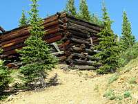
Cabin
Continue the road a short distance higher until you reach a big boggy meadow. A forest of pine trees can be seen on the other side of the meadow.
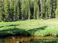
Meadow
The trail seems to end here. You will find a somewhat of a clearing in the forest on the left side. Go up the cleared area.

Clearance in the forest
You will then reach tree-line at the base of Point 12242 ft.

Near Tree-line
Head west and hike just above the tree-line to reach the 11980 ft saddle at the base of the 12690 ft sub-peak.

11980 ft Saddle
Hike up easy grassy slopes. You can go to the top of the 12690 ft sub-peak or bypass it on its southern slopes. At the base of the summit of Green Mountain itself, you will see a small rocky area that can be easily climbed.
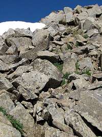 Base of Summit |  Summit |