
|
|
Route |
|---|---|
|
|
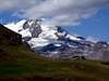
45.83100°N / 7.78670°E |
|
|
Hike |
|
|
Most of a day |
|
|
EE+ |
|
|
Approach
Gressoney Saint Jean. The trailheads are at Ondre Castel (km. 30,9) or Chamonal (km 28,8) of Valle del Lys road.
Route Description
From Ondre Castel (km 30,9 Valle del Lys road), follow footpath n.7. From Chamonal, follow marks AV1 (Alta Via n.1) or footpath n.6, rise to Alpenzù Grande and reach Montil alps, where trail n.7 gets into AV1/n.6. Both ways are steep. Montil, 2.001 m. 1h30min (1h00min from Ondre Castel).
Walkin along AV1, three alps Loage (Inferiore, Mediana, Superiore) will be found. After the third alp a great highland introduce to the steep ascent to Colle Pinter (2.777 m., 3h15min). Passed Colle Pinter, the trail goes on in Val d'Ayas side. A steep rise on stoneyground with a final narrow gully, allow to reach a plan (about 3.100 m. 4h00min), close to bivouac Lateltin (Monte Pinter). In NW direction there is Testa Grigia summit, to get to the little shelter it's better to reach in a couple of minutes the no-name pass. From no-name pass to Testa Grigia summit follow instruction as for previous route (5h00min/5h15min).
Suggestion: could be very interesting rise from former route and descend from this side. If you have your car parked in Gressoney La Trinitè, after Montil alp, turn left on Walser trail. This arrive in Gressoney La Trinitè avoiding paved road down the valley.
 |  |  |  |  |
Essential Gear
High mountain wear.