
-
 3011 Hits
-
 75.81% Score
-
 6 Votes
|
|
Route |
|---|---|
|
|
46.43971°N / 13.65497°E |
|
|
Download GPX » View Route on Map |
|
|
Hiking |
|
|
Summer, Fall |
|
|
A long day |
|
|
T3 (Swiss Hiking Scale) |
|
|
Introduction
The normal hiking ascent from the north is nice, but long and rarely done in one day. That's why it is less attractive as others, because if you choose to ascend Mangart from the north by the easiest route, you'll very likely also go down by the same route. On the other side, the descent from Mangart saddle to the bivouac is nice in combination with the difficult Via Italiana (ferrata).
Note: I haven't done the entire tour yet, only its lower and upper part. The good one hour of easy terrain by the bivouac I'm still missing.
General Information
Difficulty (grading is on the Swiss Hiking Scale): T3. It's a usual mountain hike by marked paths, in some sections they are less beaten. A few short stretches are secured by steel cables and pegs. There are also steep sections, requiring careful step, especially in poor conditions.
Orientation: Easy, the route is well marked.
Altitude to overcome: 1800 m of ascent overall (from 930 m to 2678 m).
Time for the ascent only: 5-6 hours.
Best season: Summer and autumn months, normally from July till October (or first snow). Check how the mountain hut on Mangart saddle is opened!
Best hour: Start early, depending on logistic.
Slopes orientation: north and east.
Gear: Hiking only - good shoes and poles.
Maps: Online maps (like OponTopo map or OpenStreet map) are sufficient.
Huts: Koča na Mangartskem sedlu, 1906 m, reachable by car. Bivouac Nogara, 1850 m, always opened.
Getting There
The starting point is at Laghi di Fusine, the big parking place at the upper lake, 930 m.
Parking place coordinates: 46.473349, 13.670938.
Route Description
Show a bigger map
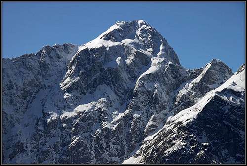
From the parking place we go southwards, following the marks and inscriptions (to "Bivacco Nogara") on plates. From the road first the trail towards Rif. Zacchi deters left. We continue right and then further right on Alpe Tamer (meadow). There we take the right branch (No. 517a) of trail again. It starts ascending quite steeply through the woods, on the right we hear water source in a ravine. Then the nice beech forrest flattens considerably and the path continues by its left, still light section. So we reach out of the forrest, on the broad, grassy slopes below the northern wall of Mangart. Some 100 m higher, there's another crossroads in the middle of the slope (by a boulder), on some 1475 m.
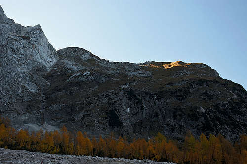
From the left the trail No. 517 comes up from Rif. Zacchi, and we continue right up, towards the distinct rocky barrier. In the corner just below the north wall, there's almost always a small waterfal. The trail at first still crosses the slopes, then it turns sharp right and starts winding up, using the best passages over the rocks and ledges. This part is steep and requires a careful step, but otherwise without difficulties. Higher on, some more rocks need to be overcome, the passage through a rocky groove and some orthers are secured by cables. So we reach the broad eastern meadows of Monte Traunig / Travnik. In a long turn the trail reaches the Nogara bivouac, 1850 m, below a big boulder, in the middle of the slope.
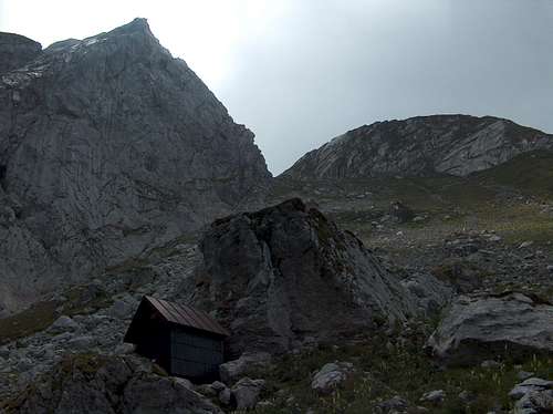
From the bivouac two routes continue. One is to the entry into the famous, very steep and difficult Ferrata (Via) Italiana. That cable route requires ferrata equipment, quite some skills and strenght in arms. The second is our normal route, which goes quite around. So, we go right, over the grassy slopes, where the trail is not so well beaten, carefully following the marks. So we reach the distict, rocky ravine, which soon brings us southwards on the main ridge, on Mangartsko sedlo / Forcella Mangart, 2166 m.
Just on the other side of that saddle we hit the broad, well marked normal ascent route on Mangart, coming up from the mountain hut. So, we turn left, go along the main ridge and later decide which of the two options we choose for summit ascent (see their SP pages):
- Normal Italian route (that's not the difficult Ferrata Italiana which we mentioned to start near the bivouac, but the normal summit ascent, going by the Italian side of the border, by the Big Ledge). 1 h 30 min, T3.
- Slovenian route. A medium difficult route (easy ferrata), 1 h 20 min, T4.
Descent
- To get down to the lakes, almost the only option is the same route.
- Of course, it's also possible to go down by the road on Slovenian side and somehow arrange the transfer around the massif - to the lakes. It must be a great tour if bikes are waiting us on mangart saddle. Then we are quickly down in Tarvisio and must then do only the last ascent to the lakes.
- The third option is used in winter conditions and in times of tour skiing. From Mangartsko sedlo / Forcella Mangart, 2166 m, we can continue along the main ridge past Monte Traunig / Travnik further towards the west. In a few minutes we reach another notch in the ridge - Klanška škrbina / Forcella della Lavina, 2055. A broad and not too steep couloir descends from it towards the N-NE, very nice in times of tour skiing. If filled with snow we are also in early summer quickly down on Alpe del Lago and by the lakes. The trail by this valley is marked No. 516.