Toggle navigation
Mountains
Routes
Images
Trip Reports
Forum
What's New
People
Areas & Ranges
Articles
Trailheads
Canyons
Huts & Campgrounds
Albums
Logistical Centers
Fact Sheets
Lists
Custom Objects
Gear
Plans & Partners
WELCOME TO SUMMITPOST
SIGN IN
REGISTER
Mount Raymond
Additional Parents
Image
Mt Raymond & Gobblers Knob...
View High-Resolution Image
Mt Raymond & Gobblers Knob...
Mt Raymond & Gobblers Knob Overview Map
Trail
,
Class 1
,
Class 2
A
-
Mill B North Fork Trail
A1
-
Southwest Slopes route (on snow)
B
-
Left Branch of Butler Fork
C
-
Desolation Trail
D
-
Right Branch of Butler Fork
E
-
SW Ridge via Baker Pass
F
-
Alexander Basin Trail (and X-country variations)
G
- Alexander Basin to Bowman Fork Trail
H
-
Bowman Fork Trail
I
- Porter Fork Trail
J
-
Thayne Canyon Trail
K
-
Wildcat Ridge
L
-
East Face Chutes
M
-
Northeast Ridge
N
-
South Ridge Left (Soleus Ridge)
O
-
Circle-All Pek - N & SE Ridges
Information is a combination of personal experience, USGS topos, and route descriptions on SP. Please let me know if any additions or corrections are needed in the map or labeling.
« PREV
NEXT »
PellucidWombat
on
Jul 18, 2005 1:39 pm
Comments & voting
Other parents
Lat/Lon:
40.65800°N / 111.701°W
Image ID:
115313
7300 Hits
71.06
% Score
1
Votes
Log in to vote
Comments
No comments posted yet.
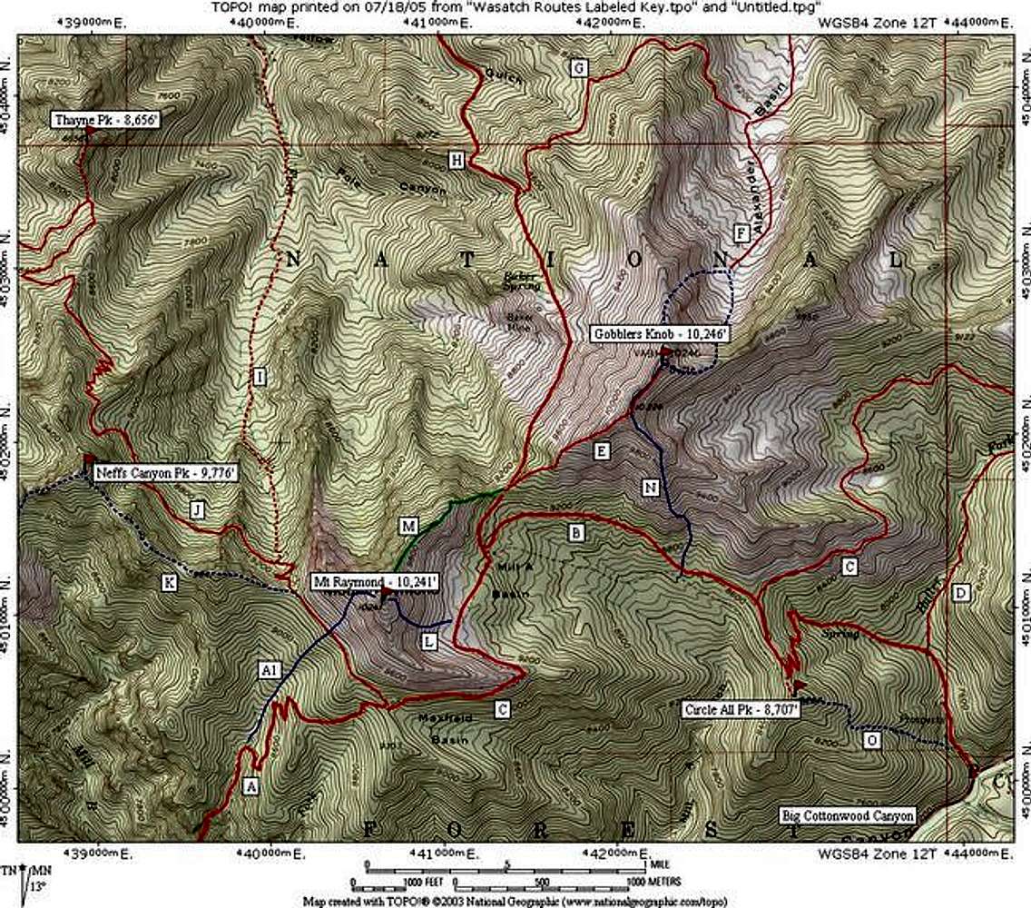
to post!
Don't have an account?
Mount Raymond
(Mountain/Rock)
« PREV
Viewing
#66 of 73
GALLERY
NEXT »
PellucidWombat's Image Gallery
« PREV
Viewing
#2039 of 2324
GALLERY
NEXT »
×
You need to login in order to vote!
User Name
Password
Remember me
Forgot your password?
Log me out when I close my browser.
Keep me logged in all the time.
sign in as a user
Don't have an account?
Register now for FREE
Rating available
Suggested routes for you
People who climb the same things as you
Comments Available
Create Albums
Register Here