
|
|
Mountain/Rock |
|---|---|
|
|
43.95000°N / 16.60000°E |
|
|
6276 ft / 1913 m |
|
|
Overview
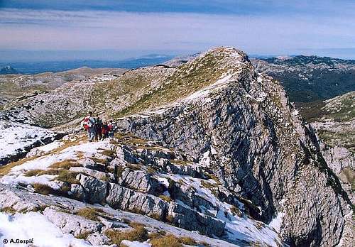 Nearing Troglav summit
Troglav (1913m) is highest peak of Dinara mountain, which became the symbol for the longest mountain chain on Balkans and gave it its name, The Dinaric Alps. Chain is stretching from Slovenia, over Croatia, Bosnia & Herzegovina, Monte Negro and ends in Albania.
Dinara mountain is huge massif on the border between Croatia (Dalmatia) and Bosnia & Herzegovina, around 100 kilometers long, stretching from NW towards SE. Mountain is divided into 4 groups: Ilica (1654m), Dinara (1830m), Troglav (1913m) and Kamesnica (1855m). Except Dinara group whole mountain is mostly grassy and contains enormous pasture areas, which were extensively used till some 20-30 years ago by thousands of cattle. Most powerful expression on the mountain is SW face of Dinara peak. Cliffs can also be found on the northern sides of Troglav and Konj peaks (highest peak of Kamesnica). Dinara mountain is also divide between Mediterranean and Continental climate. In the antic times the name for Dinara was Adrion Oros.
Troglav group is around 30km long and around 15km wide, largest on the mountain. On the NW is divided from Dinara group by Privija (1230m) pass and on the SE from Kamesnica group by Vaganj (1173m) road pass, which connects Sinj in Croatia with Livno in Bosnia. On the NE (Bosnian side) is huge Livanjsko Polje karst field (700m), which is 65km long. On the SW (Croatian side) is Cetina river valley with 15km long Perucko Jezero lake.
SW slopes (Croatian side) ascent in few steps. First step rises up to around 1500-1600m. Up to 1100-1200m slope is forested, mostly with oak and hornbeam, while above is grassy. Behind is large depression, which is true labyrinth of peaks (up to 1700m), ridges and plateaus, which are strewn with funnel shaped basins. On the part of plateau called Vjesticja Gora (around 1400m), south of Troglav, is large complex of beech forest, which looks like alien body in this world of grass and stone. Behind this area main ridge rises. From border with Dinara group front streak of peaks and main ridge gradually rise till Troglav peak. After it both gradually descent toward Vaganj pass, while pasture area between them widens.
NE slopes (Bosnian side) are much steeper and mostly forested with beech and spruce. Mostly they descent steeply, without steps, towards Livanjsko Polje field and end like cut of. Few kilometers north of Troglav peak the only step appears and it contains beautiful meadows complex Velike Poljanice.
On NE part of the group, between Bat (1851m) and Bunjevacko Brdo (1849m) groups of peaks there is huge undulating grassy plateau, few kilometers long and wide. Average altitude of the area is over 1600m. This area was glaciated.
Highest peaks of Troglav group (above 1700m) are:
Troglav (1913m)
Veliki Bat (1851m)
Bunjevacko Brdo (1849m)
Presedla (1833m)
Veliki Cilj (1807m)
Lisanjski Vrh (1794m)
Srednji Troglav (1790m)
Janciji Vrh (1790m)
Marino brdo (1789m)
Zeleno Brdo (1783m)
Jankovo Brdo (1780m)
Grkovacki Bat (1766m)
Vrhovi (1765m)
Slime (1762m)
Pistanski Vrh (1760m)
Pecinski Vrh (1735m)
Zrvinic (1731m)
Velika Duvjakusa (1708m)
and there are numerous other above 1600m.
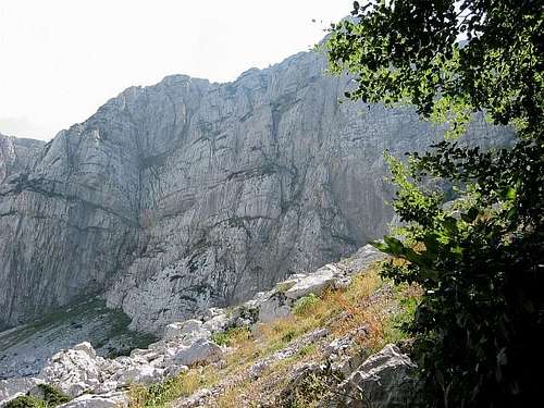 Troglav north face
Troglav (1913m) peak is located at mid part of the group. Northern side of Troglav dominates over Livanjsko Polje field as its, 300m high, cliffs rise above beech and spruce forest. Today there are around 10 climbing routes. First attempt to climb came in 1957. Bellow the cliffs is large glacial cirque, buried with scree and huge boulders. From the bottom of the cirque Troglav rises over 450m. SW slopes are grassy with lot of rock. From its foothills peak rises more than 300m and it dominates the area. But from Croatian side (roads bellow the mountain) Troglav is not so eminent because it is hidden by peaks and plateaus which are in front. It can only be seen from further away.
The origin of Troglav name is still unclear. Is it because Troglav has three head (tri glave = three heads, similar to Triglav (2864m) in Slovenia) or is it because in old Slavic mythology (before Christianity) Triglav was God of the underworld.
There are only 3 marked paths in Troglav group. Two of them reach Troglav (1913m) and third climbs on Bat (1851m), second highest peak on the mountain. This is complete wilderness where it is highly unlikely to meet anyone! In a way it is good that there are still few place slike that. It is pity that there isn't a single shelter to stay on the mountain, although there is enough grass to erect a tent. But this is also not so easy because these grassy slopes and pastures are rocky. Ridge of the mountain is suitable for beautiful panoranic path, which could connect Dinara (1830m) with Troglav and continue towards Kamesnica (1855m). Certainly there is lot of work on Dinara mountain in the future for local mountaineers.
 |  |  |  |  |
Border Story
 Troglav from Velike Poljanice
Dinara mountain and its ridge is natural border between Croatia (Dalmatia) and Bosnia. Troglav should have been border peak and highest in Croatia but its not. Before WWII mountain was extensively used as pasture. Dalmatians (croats) were more orientated on mountain cattle breeding than Bosnians. In summer they would live like nomads on the mountain and descent to valley with first snows. Dalmatians had 500 summer houses and 135 000 sheep and were using most part of the mountain while Boasnians had 20 houses and 15 000 sheep. Pastures where reason for constant dispute. In those times Bosnia was ruled by Turks (Otoman empire) while Dalmatia by Italians (Venezia). In 1730 their joint commission went on the field to determine pasture border. Line of separation was called ‘Linea Mocenigo’. Lower and larger part was given to Dalmatians while higher and smaller to Bosnians. Line was drawn some kilometer bellow main ridge of the mountain so all the main peaks belonged to Bosnia.
 |  |  |  |  |
Views
 Mali Troglav and Livanjsko Polje
View from the summit is very wide towards all sides. On the NW is Dinara mountain with huge Dinara (1830m) peak, highest in Croatia and little bit left of Troglav group. Just left of Dinara peak is Velebit mountain with easily recognizable pyramid of Sveto Brdo (1751m) (100km away). Towards W, SW and SE is huge North Dalmatian plateau with Dalmatian mountains Promina 1147m), Kozjak (1205m), Svilaja (1508m) and Mosor (1339m). Behind the plateau is Adriatic Sea and its islands (around 80km away). On the SE is Biokovo (1762m) mountain (80km away). Just left of it is rest of Dinara mountain with Kamesnica (1855m) group. Left of Kamesnica is Tusnica (1697m), which is closing Livanjsko Polje field on the SE. Behind Tusnica is Vran (2074m) and further behind, peaking over it, Cvrsnica (2228m) (90km away). On the E is huge, 65km long, Livanjsko Polje field. Behind it are 3 mountains which close the field from the E. First is high peak of Cincar (2006m). Left of it is Golija (1890m) and further left Staretina (1675m). Behind Golija and Staretina is Vitorog (1906m) (40km away). On the N, closing Livanjsko Polje field, is Sator (1872m) mountain. Left of it is Klekovaca (1961m).
 |  |  |  |  |
Winter Scenery
 North face of Troglav in winter
 |  |  |  |  |  |
Getting There
There are two starting points to climb Troglav. One is Sajkovici village, on Bosnian side and Bracev Dolac mountain village, on Croatian side of the mountain. They are just at the opposite sides of the mountain, 10km of straight line, but by car they are quite far. Over Knin and Bosansko Grahovo distance is 121km. Over Sinj, via Vaganj pass it is 90km but much of it is macadam. Over Livno, is 145km. So, these two starting points have nothing in common. Troglav from Bosnian side
~Sajkovici, Bosnia & Herzegovina~ trailhead
If you are coming to Bosnia by plane your gate to country is Sarajevo airport. How to get there check on Air Bosna, a national airline pages. From Sarajevo you can reach Sajkovici via Livno by bus.
By car Sajkovici can be accessed from many directions. If you are coming from western or central Europe you have to go through Croatia.
Via Knin: How to reach Knin check bellow. From here you head towards Bosnian town of Bosansko Grahovo, over Derala pass (965km) (36km). It is further 36km to Sajkovici (to Livno is further 39km).
Via Split: From Split you head towards Sinj. It is 26km till the junction in Brnaze village. Here you turn right towards Livno, over Trilj. It is 11km to Trilj and further 26km to Kamensko border pass with Bosnia. From here further 35km till Livno. From Livno it is 39km more to Sajkovici.
Via Bihac: This is actually shorter variation of Knin direction, if you are coming from Zagreb. It is 130km from Zagreb to Grabovac village, where you turn towards Bosnian border and Bihac, which is further 29km away. From Bihac you head towards Bosanski Petrovac, 54km away. There turn right towards Drvar and Bosansko Grahovo, 62km away. From Bosansko Grahovo is further 36km to Sajkovici (to Livno is further 39km).
Distances between Bosnian Cities and Places is useful link for car travelers.
More info on Bosnia Herzegovina find on virtualtourist, lonelyplanet and B&H tourism web pages.
 Troglav autumn
~Bracev Dolac, Croatia~ trailhead
If you are coming to Croatia by plane your first destination is certainly Zagreb. From Zagreb there are everyday flights to Split. More info about flights on official site of Croatia Airlines .
Bracev Dolac (800m) is small mountain village on SW slopes of Dinara mountain. It is accessed by 8km long macadam road, which begins in Koljane village at the foothills of the mountain, just above Perucko Jezero lake. Koljane are on the local road which is going along NE side of the lake. It is accessible from Knin or Sinj, only by car.
Via Knin, which can be accessed from many direction.
From Rijeka, along the coast.
This route is suitable if you are coming from western Europe, via Trieste (Italy).
Trieste - Rijeka 70 km
Rijeka - Knin (via Starigrad-Paklenica, Obrovac and Gracac) 293 km
From Zagreb.
This road is suitable if you are coming from eastern or central Europe via Ljubljana (Slovenia), Maribor (Slovenia) or Budapest (Hungary).
Ljubljana - Zagreb 138 km, Maribor - Zagreb 113 km, Budapest - Zagreb 347 km
Zagreb - Knin (via Plitvice and Gracac) 283 km
From Zadar: 100km
From Sibenik: 66km
From Knin you head towards Split. After 25km, at the entrance to Vrlika, turn left towards Kosore village. Road goes along edge of Vrlicko Polje field, crosses over Cetina and continues along NE side of Perucko Jezero lake (13km from Vrlika).
Via Sinj
From Split it is 32km to Sinj. From center of Sinj turn right following Han or Obrovac Sinjski signs. After 6km you cross over Cetina river at Han. On the other side of the bridge turn left towards Bitelic and straight towards Koljane (26km).
Look for current road conditions in Croatia on the page of Croatian Automobile Club.
There are so many sites on the net about Croatia. You can check site of Croatian National Tourist Board.
 |  |  |
Maps
 |  |
When To Climb
[img:20843:aligncenter:medium:Troglav autumn]Troglav can be climbed year round. It only depends what you prefer. If you don't like either hot or cold May or October are months for you.
Winter. Climate of Dinara mountain is harsh with lot of snow in winter. But the most dangerous factor is Bura wind. With mighty force it brings bitter coldness and unbearable wind-chill effect. Temperatures can drop to -30C. If the forecast is good you need crampons and ice ax. Since there are no shelters in the mountain climb must be done in a day and that is problem in mid winter because of the short day.
Summer. At this time of year it better to choose Sajkovici ascent, which mostly goes through the forest and is not hot. Bracev Dolac climb is completely without forest so it is better to start very early.
Mountain Conditions
There is no altitude meteo station on Dinara but accurate forecast is not a problem because Knin, Sinj and Livno towns are bellow mountain. To have some picture how things higher in the mountain are you can use Zavizan station on Velebit mountain in Croatia or Bjelasnica mountain in Bosnia (on FMZBiH site).WeatherOnline:
WeatherOnline home page
Croatia at WeatherOnline,
Zavizan, Velebit at WeatherOnline
Croatian Meteorological and Hydrological Association (DHMZ):
DHMZ home page
DHMZ Forecast page
DHMZ 7 Day Forecast for Croatian and World wide cities and places, including Knin
Current Weather Conditions in Croatia, including Knin, Sinj and Zavizan
Snow Depth's in Croatia
Bosnia and Herzegovina Meteo Institute (FMZBiH):
FMZBiH home page
B&H current weather and forecast page at FMZBiH
Wunderground:
Knin forecast page
Livno forecast page
Where to Sleep
There are no objects on around Troglav. It is one day mountain so it not a necessity. If you would like to spend a night or more on the mountain use a tent. Most suitable spots would be flat meadows on the Croatian side of the mountain, former pastures, with ruins of houses, which were used by people who guarded cattle during the summer.Around the mountain, you can find accommodation in Livno (Bosnia) or Sinj (Croatia). More about Livno you can find out on Cincar mountain page. Here are few useful links:
Livno
Livno hotels
Hotel Park, Livno
Sinj
Sinj @ Dalmatia.net, accommodation info
Sinj @ Travelwizard.com
Look at Sinj info page on the site of Croatian National Tourist Board
Red Tape
No limitationsDinara massif pages on SP
~ Dinara (1830m), highest Croatian peak~ Bat (1854m), third highest peak on Dinara
~ Troglav (1913m), highest peak of Dinara massif (you are here)
~ Kamesnica (1855m), SE most group of Dinara, Konj (1855m) peak is second highest on Dinara massif