Approach
The trailhead is at Crystal Lake. Crystal Lake is reached from the the Trial Lake spur road off Highway 150 25.7 miles east and north of Kamas. Follow the signs along the spur road to Crystal Lake. This gravel road is good for all vehicles.
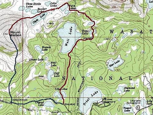
![Blue = Watson Pass and the...]() Blue = Watson Pass and the South Ridge.
Blue = Watson Pass and the South Ridge.Route Description
From the trailhead take the trail posted for Long and Island Lakes. The first part of the road is actually an old road that heads west and stays above Crystal Lake. There is a signed junction at the end of the old road. Follow the trail left for another mile while it switchbacks up to Watson Pass. To climb Mount Watson, head north cross-country from the pass. After .75 miles of fairly easy travel the route becomes a steep boulder-hop/scramble. Scramble up to the ridge, and head northwest to the summit. The climb is well worth the effort. From the summit, enjoy the outstanding view of the Wasatch Range, dozens of lakes, basins, and peaks, and views of the high peaks in the High Uintas Wilderness Area. The total round trip distance is about 4.5 miles round trip with about 1700 feet elevation gain.
![Mount Watson from the south...]() Mount Watson from the south and Shadow Lake.
Mount Watson from the south and Shadow Lake.Essential Gear
A good pair of hiking boots will suffice in the summer season. Fishing enthusiast will want to bring a pole and fish some of the many lakes surrounding the peak.

 Blue = Watson Pass and the South Ridge.
 Mount Watson from the south and Shadow Lake.