
-
 2933 Hits
-
 0% Score
-
 0 Votes
|
|
Route |
|---|---|
|
|
47.97710°N / 6.99000°E |
|
|
Hike |
|
|
Most of a day |
|
|
Walk-up |
|
|
Approach
Start point is Mittlach. From Colmar D 417 to Munster, D 10 to Metzeral. Mittlach is 3 km in the valley on the right. At the entrance of the village, turn left and park 300 meters after the church at the begin of the forest.
 |
Route Description
Way up
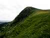
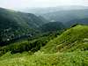
Follow the red triangle marks along the botanic path. Always in the forest, you have to climb a 600 meters level difference. You reach then the crest meadows of the Herrenberg. Nice view over the pastures. At Herrenberg collar, take right and follow the crest. You reach first the summit of the Batteriekopf (1311 m) and then the summit of the Rothenbachkopf.
Way down
Walk down the north ridge of the Rothenbachkopf to the collar and climb on the Rainkopf (1305 m) on the other side. Follow the same path in northern direction. Before Firstmiss, turn right (yellow cross marks) and follow steep down the direction Altenweier (lake). Continue along the same marks to Kolbenwasen. and your startpoint Mittlach
 |  |  |  |  |
Essential Gear
No gear necessary
Camping
Camping Municipal du Langenwasen
chemin Camping
68380 MITTLACH
Tel : 03 89 77 63 77
Opening 01-05/30-09 - 150 sites