|
|
Area/Range |
|---|---|
|
|
45.89765°N / 68.91724°W |
|
|
Hiking |
|
|
Spring, Summer, Fall, Winter |
|
|
Maine Appalachian Trail Peaks
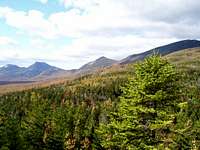
The Trail is a little different today than it was in 1937. In 1968 the MATC reviewed the trail and relocated 180 miles of it, to enhance the its appeal. The Maine section is now 281.4 miles in length, stretching across beautiful and rugged country. From the tedious Mahoosuc Notch, to the massive Bigelow range, through the speckled lake country, to Baxter Peak on Katahdin, the Maine Appalachian Trail is sure to amaze all who walk its path.
The Mahoosuc Range to Maine Highway 17

The first string of peaks are part of the White Mountains. These mountains include Mt. Carlo (3,565'), East Goose Eye Mountain(3,794'), North Goose Eye Mountain(3,675'), Mahoosuc Arm(3,765'), and Maine's third higest peak, Old Speck(4,180'). These mountains are all a challenge in themselves, but the most infamous part of this section is the Mahoosuc Notch.
Nestled between the sheer faces of Fulling Mill Mountain(3,395') and the Mahoosuc Arm, lies a mile and a half long track of giant boulders that have fallen from the tops of the oppsing peaks. In order to pass through this trechery, one must scramble, duck and crawl, in a hike that can last a lot longer than you would think for being only one mile long. To make things even better, once you have completed the notch you must hike what seems to be the never ending asent to the top of the Mahoosuc arm. Its a challenging climb, but worth the effort, Speck Pond Shelter offers a nice refuge not far from the summit of the Machoosuc Arm.
Old Speck offers great views from a fire tower at the top of the wooded summit looking South west to the Presidential Range north to Baldpate mountain. The East peak of Baldpate Mountain(3,812') offers outstanding views as well, of the Mahoosucs and the Tumbledown Jackson Range. After you pass through the sub 3,000 foot peaks of Surplus, Wyman, and Moody Mountains, you will summit Old Blue mountain(3,600')with great views in all directions.
Then comes the Bemis Range. If you do not enjoy continuously going up and down, you will not appreciate what Bemis Mountain(3,592')has to offer. There is only one small view on the top of wooded summit of Bemis towards Tumbledown Mountain in Weld. After you leave the summit you will trek across the sub peaks of Bemis, here you get some of your first good glimpes of the Mountains rising over Carabasset Valley, particularly Mount. Abramham which resembles a canoe in the distance.
After you finally desend Bemis, you asend to up Spruce Mountain to the Height of Land on Rt. 17. Here there are outstanding views of Mooselookmeguntic Lake. My Advice for hikers: don't attempt a 22 mile one day trek from Wyman mountain past the Height of Land, it only leaves you describing things you don't like, using the word Bemis, for example: "Man today was Totally Bemis!"
Maine Highway 17 to Caratunk

You then will cross the Caribou Valley road and begin the steep climb up South Crocker Mountain(4,010'). Views are limited to the rock slide encountered early on. The summits of both South and North Crocker(4,168') are entirly wooded which is strange, considering their elevation. Reddington Mountain, which has just been declared a 4,000 foot peak can be accessed through a bush wack from the summit.
After you complete the Crockers, you cross highway 27, and begin your approach up the valley's most majestic mountain range, the Bigelows. The range is nestled in the State's Bigelow perserve, which is a 36,000 acre area protcting the wilderness from developement. In 1976, a ski resort was proposed for the mountain that would rival Sugarloaf as the "Aspen of the East" luckly the citizens of Maine wouldn't have it and the Mountain was saved. The trail passes over three of the range's peaks, South Horn(3,831'), West Peak(4,150'), and Avery Peak (4,088'). The Horns Pond Lean-tos offer a great nights stay. The Bigelows are truley a stunning string of peaks. Little Bigelow(3,040) has great views, and great blueberry picking in mid August. From here you will follow the trail past numerous ponds and streams. Be sure to get breakfast at Pierce Pond camps, Tim makes the meanest 12 apple blueberry and raspberry Pancakes you will ever have for 7 bucks!
Caratunk to Katahdin

The next big stop is the famous AT town of Monson. This town offers hikers a refuge from the refuge they seek on the trail. Shaw's presents hikers a nice bed and great breakfast, but I also suggest the Laundry mat which is also a Bed and Breakfast, as well as a pub. After the vacation in Monson, the 100 mile wilderness is next. This stretch of the trail is the most remote section of the entire Appalachian Trail; once you leave Monson, there is nothing but trees and trail until Baxter State Park. As my trailmate once said, the 100 mile Wilderness is just an example of Maine showing off. The trail twists and turns to present the hiker with some of the most unbelieveable beauty they will encounter in Maine. The Barren-Chairback range (2,670') traverses over five sub 3'000' peaks for 15 miles. This section is quite difficult and should not be underestimated, especially after refilling a pack.
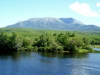
Gulf Hagas is the next natural wonder the trail presents to the AT wanderer. Screw Auger falls is a fine place to stop off and take a dip in the crisp mountain stream. As one exits the gorge, the trial begins to become steep. The next string of mountains lend beauty and difficulty to the hiker. Gulf Hagas mountain is first in a string of four peaks culminating at the summit of White Cap (3,644'). The asent up West Peak is by far the most difficult, being very steep. The views at the top of White Cap are spectacular offering scenic vistas of the surrounding Moosehead Lake region, and the big mountains to the North, including Katahdin.
After exiting the White Cap range, the land begins to become rather flat and the trail winds around a number of Lakes, accordingly this section is called the Northern Lake country. Perhaps the most fasinating point of intrest is Nahmakanta Lake with Nesuntabunt Mountain at the end of the lake. At the summit of this small mountain, the whole Katahdinauguoh range can be seen in all its glory. This is a truly impressive string of mountains, with no equal in the east in my opinion.
There is really no more challenge to the hiker after the summit of Nesuntabunt mountain is breached. Although, the trail does not lack in spectacular Maine beauty. Rainbow Lake, as well as the Rainbow Ledges offer great views of Ktaadn. Only about 3 miles from the Ledges is the end of the 100 mile wilderness, and the beginning of the last section of the trail. As the hiker exits the wilderness, they find themselves on the Goldn Road, only a short distance from Abol bridge. Here one can replenish themselves at the Abol bridge store, which unfortuanatly is rather pricey.
From here the hiker will probably meet Dave, Baxter's official greeter. He'll help in directing one to the Birches sign-up sheet further down the trail. The end of the big hike is almost over from this point, only about 16 miles of Mountain streams and forest are between the hiker and the summit of Maine's highest mountain.
Katahdin