
-
 517953 Hits
-
 99.72% Score
-
 131 Votes
|
|
Mountain/Rock |
|---|---|
|
|
45.90440°N / 68.9228°W |
|
|
5267 ft / 1605 m |
|
|
Overview
Katahdin is the highest mountain in Maine and the northern terminus of the Appalachian Trail. It is located within Baxter State Park, a wilderness-managed area in which humans come second that some refer to as the 51st state. The mountain, being a mile above sea level, towers above the comparatively low Maine lakes and forests. Due to the northerly latitude, timberline is at about 3,500 feet.
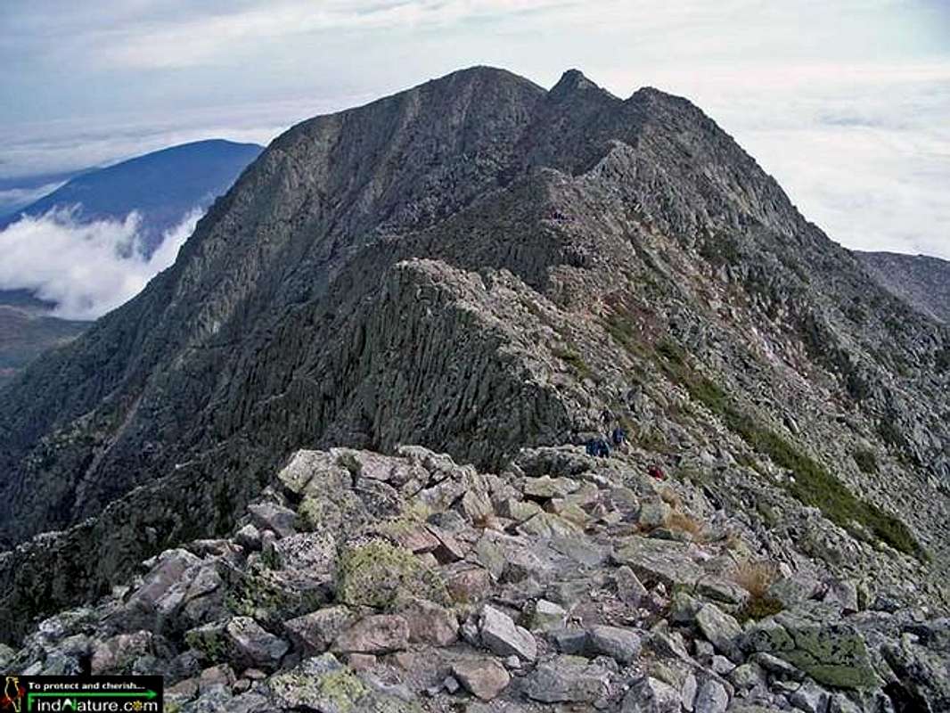
Katahdin is most impressive from the south, a sheer-like granite fortress towering to the heights. It's shape is somewhat horseshoe-like with the open end heading northeasterly. Click this link to see an excellent overview photo.There are 5 main peaks on the horseshoe, counterclockwise from the north they go: Howe Peak, Hamlin Peak, Baxter Peak (summit), South Peak and Pamola Peak. The most dominant and intimidating feature on Katahdin is the Knife Edge, an appropriately-named jagged arete only a few feet wide in places and a memorable traverse from South Peak to Pamola Peak. Katahdin is climbed frequently, being a popular destination because of its prestige.
Katahdin would appear to be volcanic in origin with it's cirques resembling craters (view from the northeast reminiscent of St. Helens somewhat) but it is actually granite that has been eroded away and carved by glaciers (source).
The many routes to the summit all involve at least some scrambling from second to fourth class and come from three general directions, north, east and southwest. However there are several technical routes both rock and ice (refer to the Routes section for details). A campsite, Chimney Pond, sits within the cirque called the Great Basin. From this point, you can ascend the Cathedral Ridge Route (1.7 mi.) that runs up the salient ridge just west of Baxter Peak or the Saddle Trail (2.2 mi.) which is a bit more pedestrian. Or if you want to head up the Knife Edge (1.1 mi.) you would ascend the Dudley Trail to Pamola Peak (1.3 mi.). You can also head west from Chimney Pond to Hamlin Peak via the Hamlin Ridge Trail (2.2 mi.) if you want to hike the entire western side of the mountain to the summit.
You can also climb directly from the east via the Roaring Brook Campground on the Helon Taylor Trail (4.3 mi to summit). This takes you directly to Pamola Peak and the Knife Edge route to the summit and bypasses Chimney Pond.
From the southwest you can approach via Abol Campground or Katahdin Stream Campground which intersect and head up the Hunt Trail (the northernmost 5.5 miles of the AT). (5.2 mi total)
There is also the possibility of approaching from the far north via Trout Brook but this is more than a dayhike/climb.
The first recorded climb occurred August 2-3, 1804 by Surveyor Charles Turner Jr. via the Hunt Spur. American author, Henry David Thoreau wrote of his 1846 climb of Ktaadn in "The Maine Woods."
For a great website about Katahdin that GuitarWizard found, click here.
Panorama Link and a lot of information on this page provided by desainme.
NOTE: The Dudley Trail was closed from 2016 - 2020 due to unstable conditions from a slide. See article here
 |  |  |  |
Getting There

Take Interstate 95 to the Millinocket-Mattawamkeag exit about 50 miles north of Bangor, ME. Proceed to Millinocket, following the signs, then turn right where the road "T's" by a high school onto Katahdin Ave. Go a couple blocks and take a left at the sign for Baxter State Park. Follow that about 16 miles to the park. From there, either take the Perimeter Road (to the left) or the Roaring Brook Road (to the right) to the trailhead you desire for your ascent. In accordance with Governor Percival P. Baxter's wishes that the park be kept as wild as possible, the roads are gravel and used to be pretty rough but aren't as bad as they are reputed to be currently (at least the Roaring Brook Road is nicely graded with fresh gravel as of Fall 2002 and still in great shape in Fall 2006).
Red Tape
Baxter State Park is tightly controlled and the amount of people allowed to enter each day is regulated. Come early if you desire to climb the mountain (even 6AM is at some times too late!) or camp in one of the campgrounds at Katahdin's base.A fee is required to enter the park ($14). When inside Baxter, make sure you respect the rules specially designed for the well-being of the wild animals. The season runs roughly from May 15 to October 15; it used to be that outside these dates a complete set of required gear was required, however, the only required gear now is a working flashlight.
You are required to sign in at the campgrounds listing your names, route and time of departure/return before hiking in. You are also required to sign in at the hut at Chimney Pond when you arrive and depart there. This may seem like a hassle but the rangers I encountered there were not looking to cause problems, they were looking out for you, The night before we climbed, they were looking for someone who was late getting out and were genuinely concerned about that party.
Baxter State Park
Reservation Clerk
64 Balsam Drive
Millinocket, ME 04462
(207) 723-5140
For more info see the Baxter State Park website as there are still many rules/requirements in certain situations. (For instance, no children under 6 allowed above treeline, registrations required for technical rock and ice climbs.)
Please note that the Park has stated they may seek reimbursement for any rescue costs involving anyone they deem being reckless.
 |  |
When To Climb
Can be climbed year-round but see the park website for any winter ice or technical rock requirements/registrations. Most climb from mid-June/July until Autumn. Conditions in winter can be brutal (remember, it's not that far from New Hampshire's Mt. Washington).Camping

Camping is permitted only by reservation in authorized campgrounds and campsites. It used to be that you had to start trying to get a campsite as early in the year as possible but it has changed so that now the earliest you can try to reserve a spot is 4 months ahead of time. If you are wishing to camp within the park , the best advice I can give is to request it then as they fill up quickly. Maine residents get preference too. During the summer the park is usually filled to capacity. (I requested reservations in January a few years ago to climb at the end of September and listed about 16 sites in order of preference. I was lucky to receive my 12th pick.) You can also try to make a reservation by phone if your desired date is within 10 days but don't count on getting a site.
Click here to see the camping rules and regulations.
There are 10 campgrounds within the park, however, only 4 are usually used for climbs. Closest is Chimney Pond. To the east is Roaring Brook. Katahdin Stream and Abol Campgrounds are southwest of the peak. Russell Pond is a bit north but could also be used.
Depending on what accomodations you want, fees can be from $9 to $75. Click here for more information about camping and for detailed information on the various campgrounds.
 |  |
Mountain Conditions
Baxter State Park(207) 723-5140
Weather Service the Park goes by
Katahdin Cam
Another webcam from 5 Lakes Lodge viewing Katahdin across South Twin Lake
Timetemperature.com's local forecast:
Governor Percival P. Baxter's decree
"Man is born to Die, His Works are Short-livedBuildings Crumble, Monuments Decay, Wealth Vanishes
But Katahdin in All Its Glory
Forever Shall Remain the Mountain of the
People of Maine"
External Links
- KnifesEdge
The Knifes Edge
- Mt. Katahdin Web Page
Here's a very informative website regarding climbing Mt. Katahdin; probably the most informative on the web by far that I've come across. Highly recommeded before planning a trip....
- Chomp goes to Baxter Park
Great pix of Ktaadn
- Pics: Helon Taylor, Knife Edge, etc.
Pictures taken on 10/11/2002. Roaring Brook, Helon Taylor, Pamola, Knife Edge, Baxter Peak, Saddle Trail, Chimney Pond
- Katahdin
Pictures of Katahdin
Brian Jenkins - Jun 2, 2005 2:09 pm - Hasn't voted
Untitled CommentGreat idea nartreb! Thanks for the suggestion and info. I will try to do this sometime soon as I think it would help out. Thanks,
Brian
desainme - Jul 22, 2003 9:09 pm - Voted 10/10
Untitled CommentJohn Gyles, who at about 9 in 1689, was captured at Falmouth Maine by native Americans. In his Odd Adventures he writes: I have heard an Indian say that he lived by the river(Penobscot), at the foot of the Teddon (Katahdin), the top of which he could see through the hole of his wigwam left for the smoke to pass out. He was tempted to travel to it and accordingly set out on a summer morning and labored hard in ascending the hill all day, and the top seemed as distant from the place where he lodged at night as from his wigwam, where he began his journey. He now concluded the spirits were there, and never dared to make a second attempt. He also notes that the White Hills above the Penobscot (Teddon) are considered higher than the White Hills above the Saco (Agiockochook)(Mt. Washington) by the Indians.
Katahdin(Catardin) had its first recorded climb on August 2-3, 1804 by the Surveyor Charles Turner Junior who reached the summit late in the afternoon after climbing the Hunt Spur.
A climb in 1819 records the Abol Slide, the Avalanche having happened in the 18th Century.
In 1845, Keep crossed the Knife Edge
Thoreau made his well known climb in about 1846 in which he refers to Ktaadn as a cloud factory and compares the lakes to a broken mirror on the green sward of the then unbroken forest. Thoreau probably ascended directly toward the South Peak from the southwest.
By 1931, James Percival Baxter started buying the mountain and surrounding territory to form Baxter State Park currently at about 204,000 acres.
nartreb - Jun 1, 2005 4:27 pm - Voted 10/10
Untitled Comment(EDIT: suggestions largely rendered moot by new features in SPv2)
Brian Jenkins - Jun 2, 2005 2:09 pm - Hasn't voted
Untitled CommentGreat idea nartreb! Thanks for the suggestion and info. I will try to do this sometime soon as I think it would help out. Thanks,
Brian
osatrik - Jul 11, 2009 5:24 pm - Hasn't voted
Official Name is Mount KatahdinLots of mountains in the country have Native American names, such as Katahdin. The official name for this peak, as recognized by the US Board of Geographic Names in 1893, is Mount Katahdin. A plethora of names were used to identify the mountain, and the summit of the mountain is officially recognized as Baxter Peak.
nartreb - Jul 11, 2009 7:34 pm - Voted 10/10
Re: Official Name is Mount Katahdin"Mount Katahdin" is redundant - like "Sierra Nevada Range". The USGS can put what it likes on its maps, but everybody who knows this mountain (starting with the landowners, i.e. the state of Maine and its state park authority, and including DeLorme, widely regarded as maker of the best maps of the Maine woods) calls it "Katahdin". The works of man are short-lived. Monuments decay, buildings crumble and wealth vanishes, but Katahdin in its massive grandeur will forever remain the mountain of the people of Maine. Throughout the ages it will stand as an inspiration to the men and women of the state. --Percival P. Baxter (for whom the highest peak was named)
Zerofence - Oct 18, 2014 8:41 pm - Hasn't voted
Update to priceNow charging $14 at the gate.
Brian Jenkins - Oct 23, 2014 8:26 pm - Hasn't voted
Re: Update to priceThanks, I actually had that on the page unless you are talking about something else? Brian
aapontyn - Jun 26, 2023 7:45 am - Hasn't voted
Alpine Starts!Alpine starts are only possible if you A) have a campsite reserved anywhere in the park the night prior to your climb and B) are physically past the gate at the entrance of the park by 8:30 Pm the night before. Otherwise, reservation or not, you are stuck waiting until 6-7AM with everyone else. If you do achieve A&B, you can start hiking whenever you want after midnight, as long as you register at the trailhead and leave your permit on your dash!