
|
|
Route |
|---|---|
|
|
43.89580°N / 114.4017°W |
|
|
Mountaineering |
|
|
Summer |
|
|
One to two days |
|
|
Class 4 |
|
|
Easy Class 4 |
|
|
Overview
This is a very brief route description for the North ridge of Kent Peak. It’s obvious Ryan peak, being the tallest summit in the Boulders, is climbed far more, but Kent peak is only .8 miles to the south. This makes a link up one of the shortest two-fer’s this side of Mt. Church and Donaldson peak in the Lost River Range.Although the rating is “easy” class 4, expect to encounter an abundant supply of rotten rock. Climbers should stick close together to avoid rock fall.
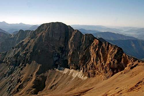
The north face of Kent Peak in the Boulder Mountains of Idaho. One of the few remaining permanant snow fields in Idaho is on the decline as evidenced by this
2004 Comparison Photo submitted by IdahoSummits]
Getting There
This route mirrors much of the “South Ridge Route”. Drive 7.5 miles North of Ketchum on U.S. 75, turn right at the SNRA Headquarters in the mouth of North Fork of Big Wood River. Drive 5.3 miles to the end of the road and a turnaround. The North Fork Trailhead is on the lower side of the turnaround. Follow the trail on the right side of the creek for 1.5 miles. The trail forks at a small pile of rocks, leave the creek and take the right fork. The trail starts to climb to the North East, follow it 2.25 miles to West Pass, (a sign marks the obvious pass). Leave the trail and climb to 11,200’ where you reach the crest between Ryan and Kent Peak. Tag Ryan Peak and then return to the crest. Although the ridge ahead looks steep and rotten, once you’re on it, it’s a pretty straight forward climb.Route Description
There are about a ½ dozen towers to cross and the class 4 climbing starts on the first one. There are two tricks to the ridge, #1, test every hand and foot hold!! There are plenty of solid holds on the entirety of the ridge. #2, all the detours are on the right side! Although both sides are steep, the right side is continuously less exposed.
Once you reach the top of the first Tower, the head trip is over, continue over more and more of the same until you reach the end and easy class 3 terrain. By the time you reach the summit ridge, you’ll miss all that air under your feet.
Descend the south ridge. A direct descent off the South West face looks tempting but you’ll encounter loose scree and talus over large slabs for much of the descent.
 The first tower on the route has more bark than bite!