
|
|
Mountain/Rock |
|---|---|
|
|
43.89580°N / 114.4017°W |
|
|
11664 ft / 3555 m |
|
|
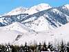
Kent Peak Overview
Geographical Breakdown: Rocky Mountains>Sawtooth Range>Boulder Mountains>

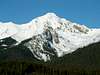
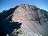
Kent peak is a beautiful rock peak located in the Boulders just to the north of Sun Valley/Ketchum. Kent is often mistaken by many when approaching as being the Boulder Mountain's high point, Ryan Peak, for its distinction as a rugged mountain with impressive south bowl exceeds Ryan Peak's somewhat dull appearance in beauty.
It would be seldom to encounter another hiker on Kent, as it is usually bypassed by those looking to bag the highest peak in the Boulders, Ryan.
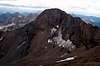
Kent Peak is an extremely rugged mountain by all accounts, the primary route that leads to the summit, involves a lengthy approach as well as sustained class 3 climbing up its notorious South Ridge. Kent's thin, noodly summit, is distinct from any other mountain in the area. Standing on the summit will rattle the nerves as the impressive north face drops over 1500 feet immediately to the valley below which possesses a permanent snow field and bergschrund. Kent's massive south bowl 1,300' in less than four tenths of a mile, surely making a fall of the summit deadly in either direction.
Kent Peak is named for Kent Easton Lake, a 1950s mountaineering enthusiast who died in the 50s from diabetes. Although not as prominent as another of the Boulder giants, Glassford Peak, this mountain won't be overlooked by those with wondering eyes in the Sun Valley area, as Kent looms highly visible on the horizon around the area.
 |  |  |  |  |
Getting There
From there, follow the relatively good dirt road 5.5 miles to it's end at a small camping area. and two major trailheads.
For access to the Northwest Ridge, please see directions to the summit of Ryan Peak.
Air Access
Access to Ketchum and Sun Valleyby air is from the Friendman Memorial Airport in Hailey, Idaho in the southern end of the Big Wood River Valley.
From the airport,
Seasonal Non-Stop Flights To
- Oakland
- Los Angeles
Year Round Non-Stop Flights To
- Seattle
- Salt Lake City
Airlines
- Horizon Air
 |  |  |
Routes
- Northwest Ridge: It is possible to ascend Kent Peak from Ryan Peak via its northwest ridge.
From Ryan Peak, descend down to the saddle and aim southeast for the summit of Kent. This ridge is very rugged and involves difficult class 4 moves and excellent route finding skills. Pleas leave this route up to professionals only.
- East Side Approaches
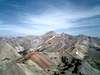
Although no attempts are on record of an approach to from the east to Kent Peak, a climb up the southeast or eastNorth Fork Big Lost River Road and have a terrible time bushwhacking and route finding up the maze of cliffs on the eastern side.
Red Tape
No permits required or red tape for climbing Kent Peak.
The North Fork Big Wood River Road is closed seasonly due to snow or heavy rainfall. During these closures a summit of Kent would be very difficult due to an approach requiring more than 15 miles.
When To Climb
If it were a normal snow year, Kent Peak's South Ridge would be snow-free and climbable by late july through mid september.
 |  |  |  |
Camping
Camping is possible at the trailhead or along first 1.5 miles of the North Fork Trail.
For a look at campgrounds across the state of Idaho go here.
Mountain Conditions
The number for the Sawtooth National Recreation headquarters is (208) 727-5000 or 800 260-5970, the folks there will be happy too update you on all local information.
Kent Peak is very remote and is isolated from any weather observations including the extensive SNOTELsites. Therefore, predicting conditions on or at the base of the mountain is very difficult. The nearest weather observation is taken from the Chocolate Gulch SNOTEL Site about 8 miles to the southwest.
These are the averages from the SNOTEL site, which site more than 5,000' lower than the summit of Kent.
| Average Yearly Precipitation | 25.7" |
| Average MAX SWE | 14.7" |
| Average Janurary Temperature | 16.8 |
| Average July Temperature | 61.7 |
Here are more links for conditions around Kent Peak.

External Links
- Sawtooth National Forest HQ
For info on closures, permits, camping etc.
pmcgrane - Aug 27, 2005 3:58 pm - Hasn't voted
Untitled CommentIf you are sick of walking up the trail to Ryan Peak and the NW ridge of Kent, it is also possible to climb directly up the SW face on 3rd class rock with a little scree on it. Begin on the lowest gray rock in the center of the face and climb straight up this faint arete. It is possible to avoid much of the scree and end up high on the NW Ridge. Follow the ridge east for a couple hundred yards to the summit.