About
Below you can read my personal account on a pleasant four-day trek along a portion of the
main ridge of
Rodnei Mountains, a lesser-known "back corner" of Central Europe. The trip took place during 7-10 August, 2009.
A technical note for better understanding of the non-English toponyms: each time the name of a peak appears in the text for the first time, the Hungarian (and in one case the German) names are given in parentheses (
in italic) after the Romanian names, which are given foremost and throughout the rest of the text.
Day 1 - Rainy reward for comfort climbing
After the previous day's full-day travel (for me: drive) from
Budapest to
Borşa Complex, we are somewhat lazy with the start. One of the three decides to spend one more day down at the
Pensiunea Ursu ("bear pension", which served as our base camp), the remaining two of us decide to ease the long and tiring ascend towards the main ridge of Rodnei Mountains by taking advantage of the ski chairlift, which operates also in summertime if there are enough "hikers" to make the operation financially benefitial.
![For the lazy ones]() riding the "telescaun"
riding the "telescaun"
As the "telescaun" (as it is called in Romanian) is about to start in a couple of minutes (and who knows whether there will be a next round and if yes, when), we finish our packing with the speed of light (well, almost) and gallop over the street, where the station is located. We buy our one-way tickets and immediately after that we jump onto the moving chairs, one per person. With big and small backbacks on ourselves, this is not an easy maneuver, but we manage. It takes some 15 minutes to make 500 m elevation and about 2 km of distance. Flying over the now green hillside I recall how tiring was to descend this terrain in the melting snow last spring... Now on the chairlift it feels like being on a luxury trip.
![Ştiol Lake]() Ştiol Lake
Ştiol Lake
Hopping off the chair at the upper station (~1350 m), our real hike begins. There's a few hundred meters more of elevation ahead of us, and despite the weather is not bad, some grey clouds are gathering. We'd better go. Reaching the
Ştiol plateau (~1600 m) still in sunshine, where we have a little rest in the vicinity of Ştiol Lake. Originally it had a very nice teardrop shape. In the 1990-ies, the local government wanted to "develop" a recreational area here, and excavated the adjacent area so that the lake became larger. Unfortunately the development was halted only after they trasformed the lake, so now you have this semi-artificial form....
The highest point of this day,
Şaua Gărgalău (Gărgalău pass, 1907 m) is already visible from here. Unfortunately, the grey clouds are more and more visible as well. We move on optimistically but not much later our ponchos have to be recovered from the packs. It's not raining badly, but it's definitely raining. That's how we reach the pass, west from which is
Muntele Cailor (
Ló-havas), whose Southern slope is a nice meadow and at the same time, a designated campsite.
![Coronghiş / Korongyos]() Coronghiş (Korongyos)
Coronghiş (Korongyos)
Setting up a tent in rain is "fun". We finish surprisingly fast. At last we're listening the drops from the inside, resting and talking about the plans for the next day. Half an hour and the rain stops, so we can come out from our shell and take a walk around. This part of the main ridge has a very gentle topography. What makes it interesting, is a group of small nivation ponds scattered around. Towards the south, we see the long, mostly forest-covered side ridges of Rodnei Mountains. The characteristic peak of
Coronghiş (
Korongyos) is attracts most of my attention. It is not among the highest summits of this range, but has a nice pyramidal shape and some precious inhabitants... Meanwhile it starts to rain again, but then it stops again, so I could set up our second tent. It was not needed at that moment, but I wanted to get acquainted with it, as I was planning to buy one later for myself (
I did it this summer, and it's already been to Durmitor). The night is spent in tranquility.
Day 2 - Failing a summit, finding a treasure
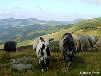
![Encounters]() baaah...
baaah...
"Good morning!" the goats and sheep must be saying, but we only hear "baaaah". Soon the herd walks right over our campsite, without showing any particular interest in our presence. The scene is funny. Two surprised campers blinking out from theirs tent, in the very middle of a sheep&goat herd. What's more, not even a bark can be heard from the sheperd dogs, which approach us very friendly. This is the opposite of the general case, when you're likely to be attacked. The key to the situation must lie in relativity. It's not us approaching the herd, it's the herd walking over us. We wave to greet the sheperds, then slowly the grazing white carpet moves on and we can get out from our tents. It looks like to be a fine sunny day, but we have to sleep one more night here, so that our third partner can catch up with us. We decide to have a go at
Coronghiş. It's close, anyway, so it should be a nice relaxation programme for today...
We have a saying "Man plans, God decides", and that was true for this plan of ours. To get over to Coronghiş from the campsite, first you have the scale
Gărgalău (
Gargaló), descend on the other side, then scale
Omului, and then depart the main ridge, descending 400 meters to the Coronghiş saddle, and finally about 200 m up the the destination. Far from being impossible, yet we felt so tired on Omului that we didn't feel like to do the 600 m elevation there and back. So we chose the easier way again, and had some rest on Omului, carefully enjoying the sun and hoping to get in better shape for the next two days, as the plan was to crawl along the main ridge with large backpacks and come back down to civilization via
Pietrosul (
Nagy-Pietrosz). Meanwhile we saw other backpackers heading for
Ineu (
Ünőkő, Kuhhorn). The second highest peak of Rodnei Mountains is well visible from here, but I know from experience that it's still a lot to go from here. On our way back, I notice some pink flowers. They're not particularly eye-catching, but I know already that this might be
Lychnis nivalis, the rare endemic species of Rodnei Mountains, so I carefully take some photos, while paying attention not to disturb them in any way. From the summit of Gărgalău, I try to contact the third person of our group, but there's no mobile signal.
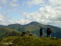
![Ineu / Ünőkő / Kuhhorn]() Ineu from Omului Ineu from Omului |
![Backpackers on the main ridge]() others are in better shape... others are in better shape... |
![Lychnis nivalis]() a botanical rarity a botanical rarity |
Clouds come and go... the weather is not bad but it's not the best for taking photographs. From the Western slope of Gărgalău I still try to catch some nice shots of the central part of the main ridge - with
Puzdrele (
Puzdra),
Laptelui Mare (
Ányes), and in the distance
Buhăescu (
Bukuly) and
Pietrosul. Getting back to our tents, we see no sign of our third companion. After some meal I set out to climb up the highest point of Muntele Cailor, a little rocky but easy summit. It's not far from us, but while getting there, I discover some more small ponds sitting in little depressions not visible from our place. From the summit, there is a nice view over to Gărgalău peak and saddle, plus one of the bigger ponds is also well visible. I see no movement at the saddle, so I decide to walk there and look down the Gărgalău cirque. A quarter of an hour later I'm there, but can't see anyone coming up. I begin to worry, as the Sun has started to decline. My cell phone doesn't receive any signal here, either. So I am left with nothing but good hope and return to our tents. We chat about the situation for some time, when I notice a familiar figure in the distance. All right, the team is finally together... We tell each other what has to be told and enjoy the promise of a fine sunset, which eventually becomes reality. I even manage to take a nice picture of it from the nearby pond. Time to sleep then.
![The central part of the main ridge]() Central Rodnei Central Rodnei |
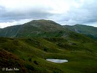
![Gărgalău / Gargaló]() Gărgalău and a pond Gărgalău and a pond |
![Golden sunset]() evening lights evening lights |
Day 3 - The dogs, the shepherd and the chocolate
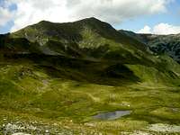
![Central Rodnei]() morning view of the
morning view of the
Puzdrele group
This time the herd is heading the other way, so we don’t get woolly company for the breakfast. The sun shines brightly and we are getting ready for the "ridge ride". The plan is to walk over to the next designated campsite, located Westwards at
Şaua intre Izvoare ("saddle in between springs", ~1840 m). The first mountain to climb is
Galaţului (
Galac). As it’s not a too fascinating hump, I come up with the idea to skip its summit and try leveling to the col on the other side, following sheep tracks. Not much is won by that, as the bumpy terrain slows us down, however we can enjoy the view on the S face of Laptelui from a slightly different angle than from the top of Galaţului. In fact it is quite a rough S face (especially in the Rodnei context).
![Sister and Brother]() not much before the dogs
not much before the dogs
We end up somewhat above the col, called
Şaua Laptelui (~1920 m), have a little rest (those backpacks are heavy, you know) and then continue on the marked trail towards
Laptelui peak. Suddenly something makes us worry. The dogs attending the herd deep down below us start to run uphill, barking aloud.
Houston, we’ve got a problem... Those warriors are so fast, they reach us within a minute, and they’re not behaving friendly. We stop and close up to form a solid group, taking a defensive position. This status quo remains until the young shepherd boy arrives, somewhat exhausted from having to scale the steep slope the dogs ran up so easily. He calms down the furious four-legged and ask for some cigarette. Being non-smokers, we don’t have any, but we do have chocolate. Deal. Afterall, we got him into some extra climbing, so it’s a fair reward.
![Walls of the Evil]() the Evil Rock from Puzdrele
the Evil Rock from PuzdreleAfter this unpleasant experience, we continue on the leveling trail in the N side of Laptelui, arriving to
Şaua Puzdrelor (Puzdrelor saddle, ~2020 m). From here both
Puzdrele and
Laptelui peaks can easily be climbed. Three years ago we chose the latter, now it was time for Puzdrele. We leave our big packs behind by some larger boulder (not that if there would be great traffic, we hardly meet a soul during the whole day) and start to scale the mountain. I have waited long for this visit (last fall we tried from the distant
Prislop pass, but started too late had to turn back from
Galaţului in order not to run out of daylight), now it becomes reality.
![Beasts of Rodnei]() the beasts of the West
the beasts of the West
Meanwhile extensive cloud cover gathers above the main ridge. Nothing to worry about, but it prevents the possibility of taking nice pictures. I do try shooting some, at least for documentation purposes. Eastwards we can see the bare limestone walls of
Piatra Rea (
Gonosz-kő). Its name means ”Evil Rock” - for sure it does not fit well for pastoral lifestyle (there’s even a deep sinkhole on its top somewhere). In the other direction a nice view opens on the two Western ”beasts” of Rodnei Mountains: the neighbouring peaks of
Buhăescu and
Pietrosul. Have I mentioned the strong and cold wind that welcomed us on the summit?
![The last rays of the Sun]() evening at the campsite
evening at the campsite
Well, it’s time to move on, especially that one of us suffers from some stomach problems and feels weak. Back in the saddle we decide on cooking some instant soup, afterall it’s lunchtime, and it sounds nice to have something to warm up our interior. The rest of the hike for today is a long stroll with minor ups and downs. Slowly we get around
Negoiescu peak, and finally arrive to our planned campsite, the ”saddle in between springs”. Luckily no one is there yet, so we can pick the best place. There ain’t much good spots here for pitching a tent, so the late-comers usually end up in the rocky trench (at least it’s protected from the wind). The spring flows weak, but it’s working, so after setting up our camp, we do the evening routine – cooking, eating, washing, visiting the dwarf pines, going to bed.
Day 4 - Down the evil path
![Dianthus superbus]() Dianthus superbus
Dianthus superbus
The last day our goal is the
Buhăescu cirque with its lakes, then
Pietrosul and the descent to
Borşa town. Before departing, I set out to take photos of some nice mountain flowers I noticed yesterday and haven't seen before. Then we continue our trek in the side of
Repede (
Repedő) peak. The other variant of the trail leads up to the summit following the ridge, but it's not so rewarding to make it worth for us this time. We rejoin the main ridge at
Obârşia-Rebri saddle. Unfortunately our third companion does not feel well and complains about weakness. So, we sit down and eat some before moving on.
![Rodnei main ridge - today]() the main ridge, 2009
the main ridge, 2009
Meanwhile I take a photo looking back to the part of the ridge we tackled yesterday: the chain of
Puzdrele,
Laptelui and
Negoiescu. Only at home, while searching for vintage photos from the area on the Internet, do I realize that someone took the same shot in 1941. Quite interesting to compare the two, and see how some of the dwarf pine has been converted to mountain pasture by man (click the photo and the link from its description to see it yourself).
Shortly after departing from the saddle, another incident takes place with shepherd dogs. This one is actually worse than the one the day before. Just getting over a smaller hump, we bump into a herd. The distance between us, the "intruders", and the flock, is very little, and our appearance is sudden. The dogs react in an instant, we only have time to shout aloud and hold out our walking sticks towards them as they ran at us. Both parties must have had a quick adrenaline kick. We do not know how the attack would have continued, as the shepherd (who was asleep) woke up and chased his dogs away by beating them merciless with his jacket. I guess he was not that delighted with our appearance, but he did not grumble at all. Anyway, we thanked him and bid farewell, let's get away from here.
![Buhăescu peaks]() Rebra lake and Buhăescu
Rebra lake and Buhăescu
Soon we arrived to
Tarniţa "La Cruce" (~1985 m) pass. Underneath lies the
Rebra Lake, which became a designated campsite lately (three years ago it wasn't). However, the place seems to have gained fast popularity. Only here do we meet more than one group of people on the mountain. Of course, popularity is not without a reason: the vicinity of the highest and the third highest peaks, and four nice mountain lakes is without competitor near and far. Another sign of "development" is a new dirt road that must have been bulldozed not long ago. It seems to be coming up from the Buhăescu valley, connecting over to the Southern side via Tarniţa "La Cruce" pass. We sit down again to rest and discuss the further possibilities. One option is to follow the markings on the ridge, but this would mean we have to descend to the Buhăescu lakes (which I want to visit so much), and then climb back.
![The third Buhăescu Lake]() the third Buhăescu Lake
the third Buhăescu Lake
To save energy, we take the other option: to take an unmarked path leveling in the side of
Buhăescu over to its lakes. The terrain and the orientation is not difficult at all, so even when the beaten track dilutes into the greenery, we can keep the direction and the level easily. At one spot we even discover an old trail marking, proving that once this must have been an official trail. Shortly after that, a small uncertainty emerges whether which way shall we continue. The direction is clear, only that we don't see whether the other side of the hump is a cliff with dead end and we should get around it, or there's nothing to worry about. I volunteer for the reconnaissance, while the others have a rest. Soon I confirm that there's no obstacle in our intended way. In fact I arrive to one of the four lakes. This one is the smallest, actully rather just a pond. Going a little further, the third (counting from above) lake appears underneath us. It has a larger surface, but it's not so deep. In fact, the two upper lakes are nicer, as I know them from photos and a distance view from three years ago.
It's only that our sick friend is really exhausted, and does not feel comfortable enough to climb up yet another 300 m to reach the saddle on
Pietrosul. What to do? Hmm... well, we're in the Buhăescu valley, in which, according to map, there is an unmarked path leading down to Borşa. Plus, we have seen the new road... it can't be much hassle, we just have to descend, which we would have to do anyway. So, giving up on the upper lakes, we begin to look for the way down. But there's a waterfall, indicating that the terrain might be too steep for backpackers. So we walk back a little and cross a gentle ridge to get over to the other small valley that hosts the new dirt road. Finally we reach it, but soon after getting to the ruins of a former sheperd hut, the road ends. What a surprise... so it does
not come up from Borşa. Well, we can do it on the footpath, at least the valley is not ruined by construction.
![Old hut in Repede valley]() the second abandoned hut, shot by Tomek, who took part in a similar adventure as us, only a few days later
the second abandoned hut, shot by Tomek, who took part in a similar adventure as us, only a few days later
All right, but where is the footpath? There seems to be nothing going along the creek, as denoted by the map. Instead, some path seems to be heading in the right direction, although through the high grass. We decide to follow the latter. For a while we can keep an eye on the creek, as we're heading in the same direction. After a while the creek deepens out of sight, but our path seems to be right. Until the point where it vanishes. Orientation is still fine, we're not yet in the forest. We also find another abandoned shepherd hut, which is also showed by the map. I begin to feel we ought to find the shortest way down to the valley. At this time two people appear from the high grass, very unexpectedly. We both are surprised to see the other. They are locals: an elderly man and woman, collecting blueberries. They ask where are we coming from, but don't seem to be fascinated about the answer. I try to inquire them the right way to Borşa, they point down the valley. Fortunately they are also going this way, so we just follow them strolling randomly down the steep slope in the forest until arriving to a beaten rocky path. Apparently we should have obeyed the map and stick to the creek...
My Romanian is limited, but I can understand the woman's words "potecă rea", that is, "evil path". As we are faster with our stiff boots (they wear wellingtons) on the rocky path, we thank the couple for the guidance and soon leave them behind. From place to place we have to climb over or crawl under fallen trees. A-ha, so that's why the man was carrying an axe with himself for bluberry collection... The surroundings are fascinatingly wild. We're deep inside the dense pinewood forest, close beside us there's the Buhăescu creek roaring. From a certain place we see a great waterfall among the woods. Fascinating. The path does not seem evil at all. In fact, it gradually gets more comfortable. Then... we arrive to a small glade and there's no clear way out. We continue "down-ish" and look for any sign of a clear track. The old couple catches up and they show the right exit from the glade. Thanks again, goodbye again.
![Deep in the wild forest]() deep in the forest, looking up to Puzdrele
deep in the forest, looking up to Puzdrele
I try to locate our position on the map, but it's scale is too large to show such details. Apparently it's not sufficient for this purpose. Knowing this, I get a little bit of worry, but at least we have the two locals behind in case we get stuck somewhere. And yes, we do... At one place the trail leads into the creek, but this is a somewhat complicated confluence of more than one creek, and there seems to be no track on the other side. All the clue we have is a plastic flask placed on a larger rock within the creek, as a route marker. The couple catches up again. We watch where they are heading... into the creek and further down in the creek. A-ha, that's where the wellingtons come handy instead of boots. We try to follow them but this time they are faster, and indeed the creek is the most comfortable way. It isn't deep, but one has to take care stepping on the wet rocks. I try to hurry up but our sick partner is getting behind. A while and our guides vanish out of my sight, so I decide to wait for the others and keep together. From here, we are on our own...
Luckily we do not run into real orientation difficulties ahead. We do have to cross the meanwhile widened and deepened stream a few times, and there are either no bridges or there are some woods of dubious stability across the waterway. I manage to save the others from two consecutive crossing, and we finally arrive to a wider road, whose bridges are still standing (it is apparent that the road went higher in the old times, as the collapsed concrete bridges witness). Just in time, as the afternoon is about to give its place over to the evening. Soon we meet a young hiker couple, coming up the valley. They know a little bit of English and ask about the way to the meteo station. Well, that's the neighbour valley, I tell, and try to discourage them from continuing further in this one, as the path is anything but clear to follow (even more so going upwards). They insist to go on, so I wish them "
Noroc!", a miners' phrase I accidentally happen to know (the equivalent of the German "
Glück auf", meaning "good luck"). We all laugh at this unexpected linguistic performance and bid farewell.
In half an hour we arrive to the first houses of Borşa, where a local minibus is about to depart. We don't want to spend much money, so we just go by it, but the driver starts and slows down by us. He offers a cheap price, so we agree to hop on. It was a good decision, saving us from an long and tiring walk on the rocky street. Arriving to the main road, we hop off the minibus, as we're heading towards Borşa Complex and not the city center. Time to hitchhike. This way of transportation is widely practiced in Romania, so one does not have to wait long for a car to slow down. We happen to get picked up by a man who drives like crazy. He also pays special attention not to miss throwing a cross on himself each time there is a cross or other religious object by the road. Well, he must need protection from above, indeed. That 5 km to Borşa Complex is not less adventurous than our hike on the main ridge of Rodnei Mountains. At the end he refuses to accept money (it is customary to pay for the hitchhike) and says us goodbye in Hungarian, a nice surprise. A little walk and we arrive to
Pensiunea Ursu at dusk. The adventure is finished, tomorrow the long (and sometimes winding) road will lead us back West to the Hungarian Plain.
Epilogue
Although we did not accomplish what was planned in advance, I wouldn't say the trek was boring. In fact, it was a great adventure, with a few sudden surprises. Some, like the dog attacks, or getting lost in the wilderness, were not too comfortable, but they came with the place and our decision to take an unmarked route. And in the end we were extremely lucky to be met by the blueberry harvesting couple who helped us to escape the tricky valley. For sure we could have descended the valley, but very likely not in a half day.
Any morals? Yes:
1) One should always mind about sheperd dogs in the Romanian Carpathians.
2) Concerning the unmarked trails, do not rely too heavily on the currently available maps for this area. And in case you have to go off-trail, reserve a good deal of time for route finding purposes.


Comments
Post a Comment