I'm comfy in here ...
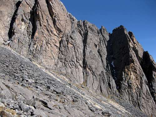
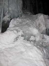
![Rock face - Illampu High Camp]() Somewhere in this boulder field we managed to find a flat spot for our tent
Somewhere in this boulder field we managed to find a flat spot for our tent ![Nightfall in high camp]() Nightfall at high camp
Nightfall at high camp
"Here”, to be precise, is Illampu high camp, a fancy name for a small tent on a boulder field, somewhere above 5200m. Just a few minutes away, the route continues on the glacier. A maze of an icefall in fact. That's why our porters couldn't go any further.
From here to the summit it's up to Eloy, my guide, and me. And depending on how you look at it, getting here took anywhere from a few days up to a year, so, no, I definitely didn't come here to sleep!
One year before
![On the road to Similaun]() Off on a trip in the Alps with friends
Off on a trip in the Alps with friendsHaving climbed in the Alps for a while now, I was looking to expand my horizon. I felt that the big mountain ranges in Asia would be too big a step up from the Alps, but how about going to the Andes? Compared to Asia it was lower, had easier access, better infrastructure and a smaller language barrier, to name just a few advantages. So, I bought John Biggar's book and started reading.
It was the fall of 2008, and I found out that, although the South American summer was approaching, the best climbing season for a substantial part of the Andes was actually in the winter! I don't quite remember why, but I wasn't really considering the peaks of the High Andes, like Ojos del Salado or Aconcagua. Maybe I was put off by the popularity, maybe it was the big step up in altitude compared to what I had climbed before, maybe something else ...
Anyway, I don't remember, but somehow I got much more interested in the high alpine peaks further north. Based on the book, I choose Bolivia. What clinched it, was the climate in the Bolivian winter:
"... often only 3 to 4 bad days in a month." Well, clearly no other Andean country could compete with that! And much better than the Alps too!
When I studied the mountains in the Cordillera Real in more detail, I was irresistably drawn to Illampu. First of all, it looked beautiful on the pictures. Add to that a real varied route, and, last but certainly not least, it seemed a bit harder than anything I had ever done before. Not much, mind you, or I wouldn't have considered it, just enough to be really tempting. I wasn't sure if I could do it, but there's only one way to find out.
In the years before, I had gone to the Alps with a group of friends. 2009 would be no exception. I thought, I'll plan for Bolivia right after the Alps, that way I'm already pre-acclimatized. Then I saw that the Dutch Alpine Club had a trip to Mont Blanc right after the week with my friends. Perfect! More preparation, more acclimatization, and with a bit of luck with the weather, I'll get to climb Mont Blanc!
So, I cleared it at work, made the necessary arrangements with my friends, booked the trip to Mont Blanc and got a plane ticket to Bolivia. All set, what could go wrong now?
Help, my ankle!
![Glen Tilt]() Glen Tilt - it happened a few hours upstream from here
Glen Tilt - it happened a few hours upstream from hereThe accident
It happened on May 1, on the second day of an easy hiking trip in the Scottish Highlands.
I was on a track, when my front foot slid away from under me on a slippery section. Everything seemed to happen as if in slow motion. As my front foot slipped, I tried to correct by instinctively tightening my leg muscles, and it
almost worked. Unfortunately, my center of gravity was already too far forward and I couldn't hold all my weight on only my back foot anymore. The momentum of the big pack on my back probably didn't help either. I keeled over, while my leg muscles kept pressing down my back foot, as if willing it to stay on the track.
Something gave.
I fell.
Slowly I stood up again, but my ankle felt awkard. It didn't really hurt bad, but it certainly didn't feel too good either. I tried to stand on it. It held, and didn't hurt too much. I took a step. That worked too, but somehow I could feel that I should definitely not try any sideways motion. I figured there was some damage to the ligaments stabilizing my ankle. But as long as I could put down my foot straight and flat, I could move.
I weighed my options.
I didn't want to take off my boots and examine my ankle, because I was afraid I might not get them back on again, and boots do a good job of keeping down any swelling. My phone had no reception. I was next to a river, and had everything with me I would need for a while, including food for almost a week, so I could put up my tent and wait for someone to pass by.
![Rainbow over the Cairngorms]() While hobbling for hours, I enjoyed typical Scottish weather. Around here I encountered the mountain biker.
While hobbling for hours, I enjoyed typical Scottish weather. Around here I encountered the mountain biker.![Glen Tilt]() A year later I was back in Glen Tilt - this is where I had hobbled through
A year later I was back in Glen Tilt - this is where I had hobbled through
I didn't know how often the track would be frequented, but since it
was a track, there would be people eventually. Alternatively, I could go try to walk, either back to where I had started yesterday afternoon, or further along my intended route. Since the pain wasn't too bad, I hoped, rather optimistically, that it might be just a sprain, and perhaps I could walk it off? And with that, I decided to go on. Had I consulted my map, I would have seen that going back was shorter, but somehow I thought it wasn't, and I didn't bother to check.
Hours later, I finally ran - well, perhaps not quite, I hobbled - into another soul. It was a mountain biker. He rode back to the nearby trailhead, where there finally was reception, and called for help.
![Fractured fibula]() The fracture after two days
The fracture after two daysRecovery
Long story short, a few days later I was back home in Amsterdam with my lower leg and ankle in a cast. The good news was that it was a clean break of the fibula, right above the ankle joint. It may seem strange, but I felt lucky. As breaks go, it couldn't have been better. The prognosis was good. Ideally, I would be looking at six weeks in a cast, and then at least that time again for the recovery, including physical therapy. I wasn't worried about my ankle getting better, but, needless to say, I couldn't help to think all the time about how this would affect my big plans. I only had three months to get back on my feet, and not just to walk, no, to climb! I was in a hurry to get well, yet there was nothing I could do. Frustrating.
After three weeks, the cast came off. The doc looked at the X-rays and was satisfied with the healing progress. I got a new cast, but this time it was called a walking cast. It looked exactly the same to me, but hey, I'm not complaining: if this means I can walk now, I'll take it! And so I walked. A lot. The cast actually started to split around the edges, but I figured, when I walk, I'll stop my leg muscle whithering away, and I might make it back into shape again on time.
After six weeks, the cast came off again, and this time the bone had healed sufficiently that I didn't need a new one. Still on track! I was really surprised how stiff my ankle had become, but I was free! That same day I walked 10 km. Ok, I was slow, but at least I walked - to one of the local outdoor shops and back. I'm pretty sure I overdid it, because my whole foot got rather big. It didn't hurt, but swelling certainly isn't a good sign either.
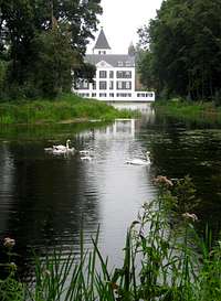
![Kasteel Renswoude]() Hiking in The Netherlands,
Hiking in The Netherlands,
in good and bad weather
I visited a physical therapist twice a week, and went to the gym almost daily. And I kept walking. Of course, my muscles were weaker than before, but I was pleasantly surprised how well my cardio shape had held up. I exercised as hard as my therapist allowed me - to be honest about it, I must admit that I probably pushed a little bit harder still. I had a purpose, and for that I needed strong legs and be in excellent shape again. After exercising, I cooled my ankle with an ice pack to keep it under control.
Testing my ankle
By August, my ankle, while still less flexible, was hardly swollen anymore after excercising. I figured it was strong enough to at least try it out, and so I went to the Alps. I was careful, especially going down scree slopes, but my ankle gloriously took everything I threw at it without complaining.
I declared my ankle healed on August 18. And although I realized that my cardio shape wasn't quite back to what it was before, it wasn't too far off either. So, off to South America!
Bolivia
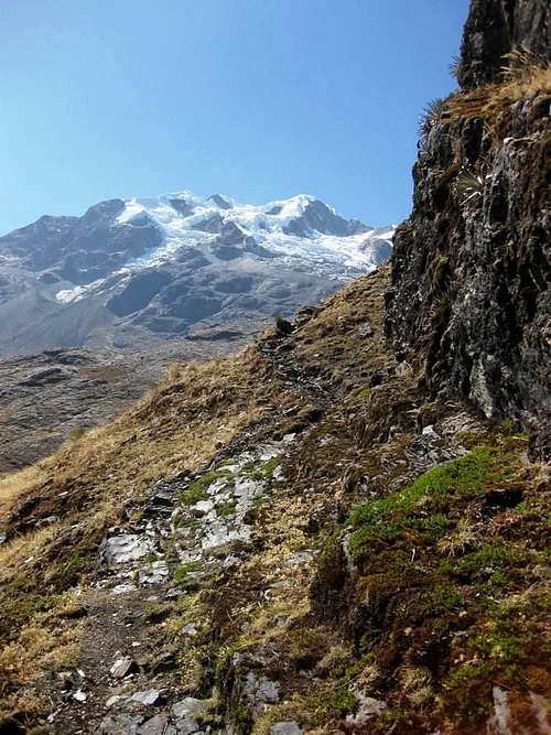
![Illimani from La Paz]() Illimani from La Paz
Illimani from La PazLa Paz and the southern Cordillera Real
Sight seeing
The first week I spent sight seeing, in and around La Paz, including a short trip to Chacaltaya to soak in some more altitude. After that, the serious business started, for which I had hired a local guide.
Fun ... and some doubts
We had a fun week and a half of climbing around La Paz. At times I thought I was slow, and was having serious doubts about whether I would be able to climb Illampu, which was to be the highlight of my Bolivian trip. I was already having a very good time without it, enjoying fantastic scenery and great climbing. Without realizing it at the time, I tried not to get my hopes up too much, in case Illampu wouldn't work out, but if it did, that would make it truly special!
Especially when we were ascending Illimani in what felt like a crawl, I realized I might simply be too slow. Was it lack of acclimatization? Or was I not in a good enough shape to begin with? Ah well, so far we succeeded on every mountain we tried, so let's keep taking it one mountain at a time.
![Laguna Chilata and Ancohuma]() Ancohuma from Laguna Chillata
Ancohuma from Laguna ChillataThe northern Cordillera Real
![Laguna Chillata]() Camp site at Laguna Chillata
Camp site at Laguna ChillataLaguna Chillata
Starting early in La Paz, we took the local bus to Sorata, followed by a short taxi ride up the road to where we would meet our
arriero. He wasn't there, and Eloy, my guide, started asking around while we were eating. I wasn't worried.
Eventually, the mules and then our arriero showed up. There was a discussion about fees, which I couldn't quite follow. Although there had been an agreement before, the arriero and porters, who we would need higher up, wanted more. I don't know how Eloy dealt with it, but he did. It was only a few hours easy walking to Laguna Chillata, our base camp, while mules carried most of our gear.
Ancohuma High Camp
Above Laguna Chillata, the terrain gets too hard for mules. While we were having breakfast, two porters came up from the valley to carry our gear instead.
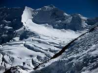
Normally, Laguna Glaciar (just over 5000m) is
the spot for the second camp. You'll need to be reasonably acclimatized to even make it there on the second day. It's a big and beautiful glacial lake, and would certainly be a nice, albeit cold, camp site.
However, after a short break we continued on the rocks and moraine alongside the weird glacier, and only stopped when we couldn't avoid going on the glacier anymore. The porters had no glacier experience, or gear, so that was the end of the line. We set up our high camp on the glacier, and the porters hiked back all the way down to the valley! I don't think they were overpaid ...
Then again, a porter earns a lot more than an average wage, and living in Bolivia is very cheap, so everybody is happy :)
![Let s have some tea]() Let's have some tea
Let's have some tea![Upper slopes of Ancohuma]() Upper slopes of Ancohuma
Upper slopes of Ancohuma![Steep section on Ancohuma]() The direct route on the west face
The direct route on the west faceSummit Day
The third day, in the middle of the night, we started our summit bid. The climb wasn't really difficult, but very, very long indeed! In particular there was this seemingly endless, almost flat glacier section. It took forever to cross. The snow was hard, so why was I going so slow? I guess I was feeling the lack of oxygen ...
As we got closer to the summit, things got more challenging. Eloy decided to take the direct route to the summit, via the west face. Not
real steep, but enough to make it interesting. He lead out, then belayed me up a couple of steep icy pitches. I wondered, was this the easiest route, or was he perhaps testing me for Illampu?
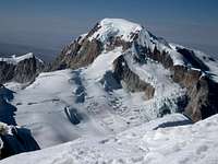
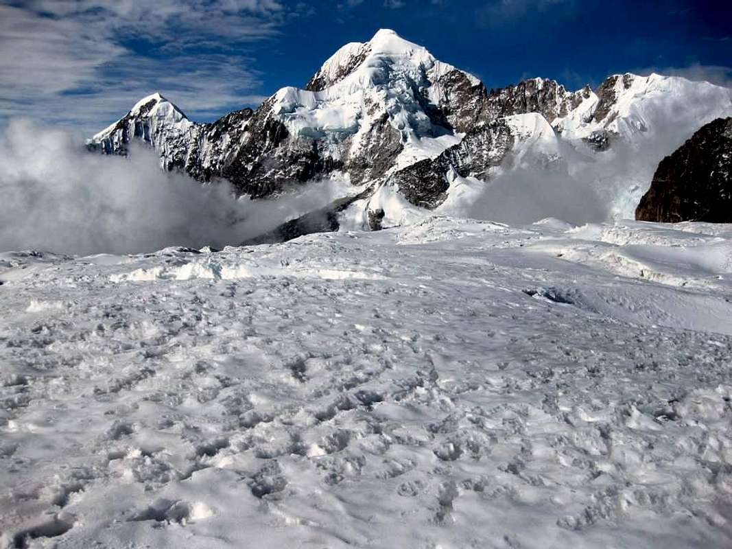
![Illampu from Ancohuma]() Illampu from Ancohuma. See that saddle just left of center? The normal route comes up a steep snow/ice face from the other side, then follows the ridge all the way to the summit.
Illampu from Ancohuma. See that saddle just left of center? The normal route comes up a steep snow/ice face from the other side, then follows the ridge all the way to the summit.![Descending Ancohuma]() Looking back at the summit from the south-west ridge
Looking back at the summit from the south-west ridge![Cornices on Ancohuma]() Cornices on the south-west ridge
Cornices on the south-west ridge
After enjoying the summit, we descended a slightly different route. First down the south-west ridge, then rappelling. That might also have been easier on the way up, I thought ...
The long slog across the glacier seemed easier than before. It was a gentle slope, not flat, as it had appeared in the dark.
As we got lower, and closer to our camp, I started wondering if our porters would be waiting for us. We were late, slowed down not by me this time, but because we kept sinking away in the old snow as it was softened by the strong sun. But, sure enough, they were waiting patiently by our tent. I was quite happy about that, because that meant we would be able descend to Laguna Chillata that same day, a much warmer place than high on the glacier. But man, these porters sure cover a lot of ground!
![Clouds coming up]() Clouds rising from the valley as we go down
Clouds rising from the valley as we go down![Love birds]() Love birds having a rest day too
Love birds having a rest day too![Laguna Chilata]() The end of a tranquil day
The end of a tranquil dayA rest day and sun bathing
To recharge for our next challenge, we had a lazy day around Laguna Chillata. I hiked around it – probably not even a kilometer – that's all. I have to admit that while it's a nice little lake, there is no beach. Plenty of sunshine though, and at 4200m high and only 16 degrees south of the equator, it burns strong!
![Farewell to Ancohuma]() A last look back, before leaving Laguna Chillata
A last look back, before leaving Laguna Chillata![End of the line]() The normal route between Laguna Chillata and Huila Khota drops down a bit into a valley. I tried to avoid that a bit by staying higher on the slopes, but that didn't work out as I was hoping for. This was a dead end.
The normal route between Laguna Chillata and Huila Khota drops down a bit into a valley. I tried to avoid that a bit by staying higher on the slopes, but that didn't work out as I was hoping for. This was a dead end.Surprise at Illampu Base Camp
Day five. Our arriero brought mules to do the hard work again, dragging our gear to Aguas Calientes, base camp for Illampu. First to the north, skirting the slopes, then over the high pass of Huila Khota.
I hadn't expected anybody, but as we arrived, there were tents all over the place! As it happened, there was a big group of aspiring mountain guides on a training course. They had been practicing on the glaciers coming off Illampu, and climbing Pico Schulze and Illampu themselves. That was most useful for us, and of course we asked them all about the conditions up there.
![View from Huila Khota]() View from Huila Khota
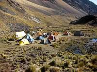
View from Huila Khota![Aguas Calientes]() Lots of tents at Aguas Calientes
Lots of tents at Aguas Calientes![Approaching Illampu]() Approaching Illampu HC
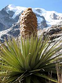
Approaching Illampu HC![Local flora]() Local flora
Local floraHigh Camp
Day six. Porters did the real work again today, for the short haul to our Illampu high camp. We hiked with our day packs. The porters went back to sleep at base camp.
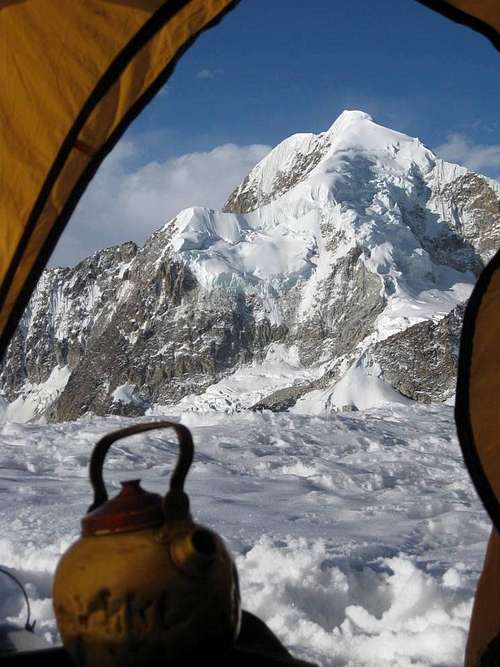
There wasn't really a good flat spot in the boulder field next to the glacier, so I spent an hour doing some construction work. I could feel that I was getting used to the altitude, lifting and moving around these big boulders to enlarge our tiny flat spot was easy! Finally it was almost big enough for our tent. No room for the vestibules though: the back door was blocked by higher rocks and at the front there was a serious step down, but we were happy with it! We ate, drank, and went to bed at dusk.
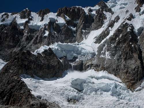
![A small avalanche coming down from Illampu]() The north side of Illampu from HC - see that small avalanche?
The north side of Illampu from HC - see that small avalanche?![Bed time]() The sun is about to set, it's bed time
The sun is about to set, it's bed timeTbe big day!
It's eleven o'clock. The alarm goes off. I'm warm and comfy in my sleeping bag and I don't feel like getting up at all. But hey, I didn't exactly come here to simply lie in my sleeping bag, now did I?
Although I'm not at all hungry, I force myself to eat a double size breakfast and drink some tea. We leave at midnight.
Even simply walking isn't easy. That big breakfast feels like a brick in my belly. I knew that that was going to happen when I crammed it down, but I'll really need the energy later. Eloy had predicted we would need ten hours to the summit, based on how long we were climbing on Ancohuma, which took almost eight. This one is more difficult as well as longer.
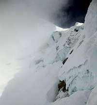
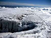
After a few minutes, we reach the end of the rocks and put on our crampons. From there we zig zag though the icefall, trying to find a way through the maze of crevasses. I suppose with a lot of snow it might be easier - until you fall into a hidden crevasse of course. We're quite late in season, so there is only old, hard frozen snow and we can
see the crevasses. I'm happy with that. Occasionally, instead of wasting time to find an easy route around, Eloy climbs a short section straight up. Fine by me. As long as we don't go down, we get closer to the summit, right?
After the icefall we reach a more or less flat glacier, kind of a plateau between Illampu and Pico Schulze. Without porters, this is the usual place to set up a high camp, but that would have meant that we would have had to carry all our stuff up through the icefall ourselves. I prefer two more hours of climbing on summit day, with a much lighter pack.
![At the bottom of the ice face]() At the bottom of the wall - the flash of my camera isn't strong enough to illuminate all of it
At the bottom of the wall - the flash of my camera isn't strong enough to illuminate all of it
I hadn't thought about it for a while, but now that my breakfast has been digested, I suddenly realize that I'm feeling pretty good. Energetic even! Nevertheless, I pace myself, knowing that we still have a long way to go.
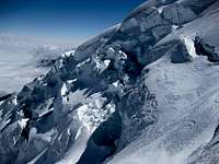
After the saddle follows the crux of the ascent: the 300m ice wall. In base camp, Eloy had enquired about the current conditions and based on that, we start all the way to the left. The wall is higher and slightly steeper there, but on the right hand side would be a big bergschrund, making access to the wall problematic.
Eloy leads the first pitch, sets up a belay and signals for me to follow. He doesn't place any protection in between, so we're making good time. I estimate that it's 40 to 50 degrees and understand his decision. However, gradually, the wall gets steeper and steeper. I place my axes purposefully instead of wasting energy hacking into the ice. I'm very focused. All my senses are heightened, I feel truly alive! At one point, one foot slips away, but I'm still firmly on the wall on my other foot and one axe. No problem, that's why you climb with two feet and two axes. And I'm on belay of course, but I don't really want to put that to the test. After seven pitches, and much quicker than I had expected, we reach the ridge at the top of the wall. Even though it's still a few more hours climbing on the summit ridge from here, with at least one very steep section, I'm convinced now that we're going to make it!
![The sun is coming out]() Early morning sun high on Illampu
Early morning sun high on Illampu
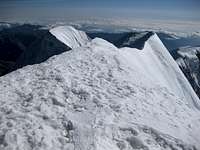
At some places, the ridge is narrow and we're very focused. Dawn is approaching and we can see just a hint of the steep drop-off to either side. Hundreds of meters into the void and certain death waits down there. If either of us would fall off, the other would have to jump down the other side to have a chance. Best not to fall then.
Where the ridge gets wider, we have a short break to eat and drink a little. Normally, I just keep going at a steady pace, but I need more of these short breaks now.
Finally, the last challenge appears. Right before the summit, the ridge steepens once more, perhaps to 60 degrees or so. However, it's snow this time instead of ice, not very hard frozen, and that's a lot easier. Fuelled by a dose of chocolate milk we go up this last obstacle. After that, it's just a stroll to the summit. Eloy and I congratulate each other: we've done it!
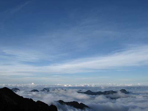
We enjoy the views around us. Big brother Ancohuma is a few kilometers away, but looks tantalizingly close. I even start wondering about the connecting ridge ... but no, that would be crazy. Further south, the length of the Cordillera Real unfolds in the morning sun, which is already very strong despite the early hour. To the east we see clouds and not much else. Below these must be the jungle of the Amazon rain forest (technically, it's the Yungas, I think). Far away to the north we see the peaks of the Apolabamba. And to the west, far below us, shines famous Lake Titicaca.
![Crowds on Illampu]() As we're going down, we'll pass many climbers from the big group of guides - they started at Aguas Calientes!
As we're going down, we'll pass many climbers from the big group of guides - they started at Aguas Calientes!![Cornice on Illampu]() Going down, I noticed there was a cornice!
Going down, I noticed there was a cornice!The descent
The snow on the ridge is still firm and so we can descend very fast, until we reach the top of the ice wall again. This time Eloy chooses the other, lower, side. By now the sun has come around the mountain and is shining on the ice wall, exposing the real danger of Illampu. The glaciated saddle below the wall is strewn with small and large boulders ...
Repeatedly, Eloy makes a belay and lowers me down the full length of the rope, then climbs down himself. Gradually, we also move away from the right hand side of the wall.
By the time I'm half way, a couple of rocks come whizzing by. As if we need more encouragement to descend as fast as we can! Almost at the bottom of the wall, I reach the top of the bergschrund. There is still some more rope, but were I to descend any further, I would disappear in it! It's too wide to get across and gain the glacier below the wall. Eloy can't see the problem and wants me to go down further, but shouting and gesturing I manage to make him understand that he has to come down too.
After a short traverse on the wall, right above the crevasse, we find a place to climb down and cross it. We don't stop, but go a long way away from the wall before finally dropping down on the glacier for a much earned rest.
Tired but happy we negotiate the icefall again. Only now can we see what a labyrinth it really was. And we had to negotiate that in the dark ...!
When we leave the glacier to reach our tent, our faithful porters are already waiting for us. We rest, eat and drink for an hour or so, before we break camp and head down to base camp, where we celebrate by hitting the sack right after diner ;-)
Real food again
The last day we hike out over Huila Khota to a village. It must be Lakathiya, but no sign to make sure. Never mind, a new road had recently been constructed and we take advantage of it by calling a taxi from Sorata. By lunch time we can celebrate again, properly this time, at one of the many pizza joints in Sorata. Climbing mountains is a hungry business!
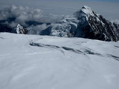
![Illampu]()
Illampu from Ancohuma HC
THE END
A few words ...
First of all, thanks to the lone mountain biker, the Cairngorm Mountain Rescue Team and the GP at Braemar. Thanks also to my friends and colleagues at work who helped me in all sorts of ways when I wasn't mobile. And finally a special word for my physical therapist, who worked hard to help me getting my ankle back in shape so quickly.
Practical information
The book
The Andes – A Guide For Climbers, John Biggar, 3rd edition, July 2005. ISBN 0-9536087-2-7.
A rough route map
NOTE: Early 2012, something changed on Wandermap, and since then, most of their embedded maps don't look too good. I hope that Wandermap fixes the problem soon, or I'll have to move my route maps elsewhere. For the time being, if you select Google Terrain View manually (from the menu in the upper right of the embedded map), the map I intended should appear again.
The start and finish can be reached from Sorata by taxi.
I didn't record the route by GPS, but recreated it from memory, notes, and using Google maps. As the satellite image resolution isn't very high, I couldn't see the hiking trails, and some areas are covered by clouds, so don't expect to be able to follow it too closely. According to Wandermap it's 42 km, but with all the zig zagging and other details, I guess that the real route is somewhere between 50 and 60 km, maybe even more. However, it's not really the distance that matters here of course. And as for route finding, if you hire muleteers and porters, they'll know the way up to all the camps.
The locations of the two high camps are by approximation, as is the start of the hike. I think I've got all other points of interest pretty accurate, including the end. For example, using the satellite images, you can clearly see the lakes, and some houses of the little village near the end.
You want to ignore some of Google's labels, they're way off the mark.
Day by day schedule
| 1 | From La Paz by small bus to Sorata, then a taxi to where we met our muleteer (>3000m). We hiked a few hours to Laguna Chillata (~4200m). |
| 2 | Bypassing the usual camp at Laguna Glaciar (~5040m), we set up high camp on the glacier (~5450m). |
| 3 | Ancohuma summit (6427m) and back down, all the way to Laguna Chillata. A very long day. |
| 4 | Rest. |
| 5 | An easy day, over Huila Khota to Illampu base camp, Aguas Calientes (~4620m). |
| 6 | Another easy day, to Illampu high camp, right before going on the glacier (~5250m). |
| 7 | Illampu summit (6368m) and back down to Aguas Calientes. Another very long day. |
| 8 | Back over Huila Khota halfway down (~3950m) to Sorata. From there by taxi to Sorata and by bus to La Paz. |
Accommodation and eating
In between climbs, I stayed at Hotel Osira in La Paz. A nice place with very friendly staff.
My favorite restaurant, if only for lunch, was Paceña la Salteña. Check it out!
Additional notes ...
There were no entrance fees anywhere in the Cordillera Real. From my hotel in La Paz and back, the all-in cost for being privately guided on Ancohuma and Illampu was USD 2100 plus tips - afterwards I bought Eloy, my guide, a celebratory dinner and gave him one of my Petzl Aztar ice tools. He was moved to tears by that, but he thoroughly deserved it. I was very happy with him, and would climb anywhere with him without hesitation.
However, I was less impressed with the intermediary through which I had booked. Nothing serious, just a lot of minor issues that were not quite as they should have been. Just one small example being the hassle that Eloy had to deal with when the arriero/porter asked for more money than he had expected. I have the strong impression that, with this agency, if you happen to get a less professional guide, you´ll notice a lot more details than I did, or suffer a bad trip. If I go to Bolivia again, I won´t be using them, but call Eloy directly. Feel free to pm me if you want to know more.
In Bolivia, when not on a climbing trip, I stayed at Hotel Osira in La Paz, where I paid something like 30-35 USD per night (for the exact number, I would have to look through my old credit card statements), including breakfast. They had recently gotten new management, so it may have been bad before, but when I stayed there, the staff was very friendly and helpful, the room was nice and always had hot water. Without hesitation, I would stay there again if I would find myself in La Paz again.


Comments
Post a Comment