
|
|
Mountain/Rock |
|---|---|
|
|
15.85343°S / 68.54084°W |
|
|
Mountaineering, Ice Climbing, Mixed |
|
|
Summer |
|
|
21085 ft / 6427 m |
|
|
Overview
Both Ancohuma and Illampu are located in the northern Cordillera Real, they dominate the east coast of Lake Titicaca (especially from Isla del Sol)
Ancohuma was first climbed by two Germans mountaineers - Adolph Schulze and Rudolf Dienst on June 11th 1919 from Cocoyo via Laguna Negra. The two climbers needed 6 days to reach the summit.
Titicaca]
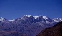 Ancohuma from the road to Sorata Ancohuma from the road to Sorata |
 Illampu (left) and Ancohuma Illampu (left) and Ancohuma |
|---|---|
 Illampu and Ancohuma Illampu and Ancohuma |
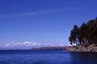 Illampu and Ancohuma from Lake Titicaca Illampu and Ancohuma from Lake Titicaca |
Getting There
Starting point to climb Ancohuma is Sorata. The cheapest way from La Paz to Sorata is by bus (In 2005 the buses depart from La Paz at the cemetery district several times daily).
There are several hostels and hotels in Sorata. Organize further transport (4x4 and mules) at the trekking agencies located near "Plaza General Enrique Penaranda" - Soratas main square.
 Sorata Sorata |
|---|
There are two Normal Routes for Ancohuma:
- Travel by 4x4 to Cocoyo and continue via Laguna Negra (Laguna Jacha Leche Khota)
- via Laguna Glaciar (Laguna Glaciar is also a nice trekking trip 2/3 days)
Red Tape
no restrictions (Jul 2005)
When To Climb
June to August are usually the best months to climb (this period is the Bolivian winter, which has quite stable weather with no rain/snowfall). The later you climb (August ...) expect cold wind and penitents.
 Laguna Chillata Laguna Chillata |
 Walking up to Laguna Glaciar Walking up to Laguna Glaciar |
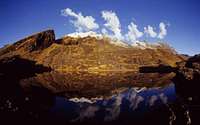
 Laguna Glaciar (and Pico Schulze) Laguna Glaciar (and Pico Schulze) |
|---|---|---|
 en route to the high camp en route to the high camp |
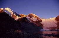
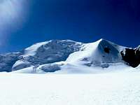 Ancohuma from the high camp Ancohuma from the high camp |
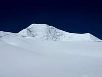 Ancohuma from the high camp Ancohuma from the high camp |
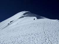 Ancohuma Northwest Ridge Ancohuma Northwest Ridge |
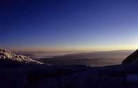 sunset (descending to Laguna Glaciar) sunset (descending to Laguna Glaciar) |
Guide Books, Maps etc
Maps: DAV Cordillera Real Nord (Illampu) 1:50.000
(there is also an IGM map available)
Guidebooks:
- Bolivia - A Climbing Guide by Yossi Brain (ISBN: 0-89886-495-X)
- The Andes of Bolivia by Alain Mesili (ISBN: 99905-79-08-3) - www.andes-mesili.com
- Boliva - lonely planet by Andrew Dean Nystrom et al. (ISBN: 1-74104-018-3)
Miscellaneous Info
- It is nearly impossible to buy white gas for the stoves in La Paz. Butane/Propane canisters are available at trekking agencies in La Paz.
- Basic food is available at the market in Sorata. Bring the food for the high camps from La Paz.
- Several cartographers (also the Times World Atlas) have claimed that Ancohuma is the highest mountain in Bolivia; and have stated the height up to more than 7000m, which would be the highest and only mountain over 7000m outside the Himalayas. The actual edition of the DAV Map (Cordillera Real - Nord, Illampu) states Ancohuma's altitude 6427m.
DoJo - Oct 17, 2005 6:30 pm - Hasn't voted
Untitled CommentWe did not find any white gas in La Paz. We heard that one trekking agency in La Paz sells white gas (but too late for us)
Corax - Aug 28, 2005 1:54 pm - Voted 10/10
Untitled CommentAncohuma's official ranking is number 21 in South America.
JXM - Oct 12, 2005 10:18 am - Voted 10/10
Untitled CommentBring a multifuel stove. Kerosene and white gas (bencina blanca) can normally be found in the auto workshops and painting shops.
DoJo - Oct 17, 2005 6:30 pm - Hasn't voted
Untitled CommentWe did not find any white gas in La Paz. We heard that one trekking agency in La Paz sells white gas (but too late for us)
OWA - Nov 30, 2005 3:22 pm - Hasn't voted
Untitled CommentThe elevation controversy has been put to rest. In 2002, OWA of Colorado guided a group of teenagers, to the summit and confirmed the actual height of Ancohuma to be 6425 m +/- 2m. The project was sponsored by Trimble and OmniStar and overseen by Jerry Brown of Bear Creek Surveying in Durango who has now mapped the Colorado Trail 3 times and rediscovered the lost Silver Trail in Copper Canyon, Mexico. Here's the link to the full story --http://www.bearcreeksurvey.com/anchouma.htm
rgg - Apr 23, 2014 4:40 pm - Hasn't voted
Coordinates are a bit offTry these: 15.854°S / 68.542°W