Overview
The first backpacking trip of the year into an area that I’d never been to, with three guys that I hadn’t backpacked with previously, one of whom I hadn’t met before. Pretty exciting stuff!
June isn’t usually the start of my season in the Colorado high country, especially not before the middle of the month. But the snowpack was a little on the light side this year and in spite of elevations over 12,000 ft, the Lost Creek Wilderness, I was told, tends be snow free earlier than most in Colorado.
The Plan
Although I’d heard of the Lost Creek Wilderness, I knew next to nothing about it. The idea to go there was Jeff’s, he being familiar with it from his days working for the Forest Service and from having backpacked there before. Jeff, Nelson, and Jeff’s friend, Jonathan, were heading there in June and when my hiking buddy, Nelson asked me if I wanted to go, I jumped at the chance.
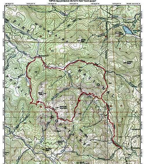
After discussing our options for the trip, Jeff suggested doing the big loop and traveling counterclockwise. It laid out like this: Goose Creek TH>Wigwam Trail>Lost Park>Bison Pass>McCurdy Park>Lake Park>Hankins Pass>Goose Creek TH. About thirty-five miles all tolled, with a substantial amount of elevation gain and loss. Starting and ending TH at 8,200 feet, max elevation enroute at about 11,900 feet. A pretty fair hike for sure!
We decided to spend 4 nights, mapped out our route and worked out most of the details in May. In checking on trail conditions with the Forest Service on June 7th, two days before we were to leave, Nelson found out that there’d been a big blowdown in the Lake Park area and that the trail in that area was impassable. So, we changed our route accordingly. Instead we’d take the McCurdy Park Tr back to the Goose Creek Tr then retracing our route back to our starting point at the Goose Creek TH. Seemed like a good alternative, maybe even better than the original plan, though it was not a complete loop and it looked to be a wee bit longer-closer to forty miles with + & - 8,400 to 9,000 ft.
By the time it was all said and done, close to forty miles and flirting with 9,000 ft elevation gain and loss
Day by Day
Sunday, June 9th
Picked up Nelson and Jeff a little after noon and drove to the Bucksnort Saloon, where we were to meetup with the 4th member of our group, Jonathan, whom I’d not met before. The saloon’s about a 1/2 mile up a narrow, one-lane dirt track from the metropolis of Pine. Interesting place that Bucksnort. The name gives you a fair idea of what kind of establishment it is. The place was packed as one might expect on a sunny, Sunday afternoon in June. Once Jonathan found us, we grabbed a table and after a couple beers and some grub, we were off to the next stop-the Goose Creek campground.
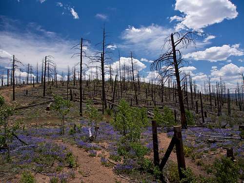
![Hayman Fire]() Hayman Fire ~ Photo by Nelson
Hayman Fire ~ Photo by Nelson
A long, dusty, washboard of a road brought us to the campground but only after passing through the devastation left by the 2002 Hayman Fire. Some of the worst I’ve ever seen! The only living vegetation being patches of wildflowers scattered among the blackened stumps and stick-ups. Fortunately for us, the campground survived the fire and even more fortunately, we found some campsites available. After getting set-up, we turned in just before dark:30.
Monday
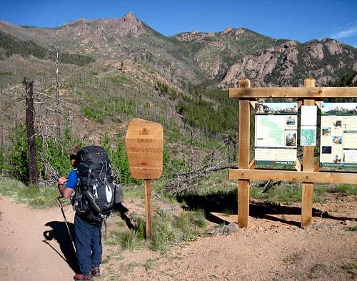
Up in the morning shortly after sunup. Weather-clear and sunny. Packed up and drove a short distance to the TH. On the trail @ 8:15. Jeff and Jonathan (J2) were off in a flash with Nelson and I bringing up the rear. Nelson had told me that these guys were fast hikers and he wasn't kidding! Once we got away from the TH, we thankfully left behind all evidence of the burned-out forest.
![Trailhead]() Goose Creek Trailhead
Goose Creek Trailhead
Tough, rollercoaster kind of trail. Probably because the trail followed an old jeep road which went straight up one side and straight down the other of every hill it encountered.
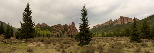
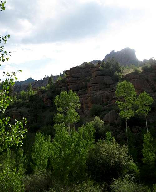
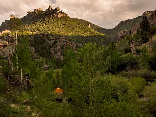
The trail passed through some beautiful country with dramatic rock formations all along the route. It also passed by a spur trail at 3.5 miles, that led down to the remains of an ill-fated late 19th/early 20th century attempt to dam the creek to create a reservoir. Nelson went down to check out the site while I chilled at the junction, trying to ration what energy I had for the rest of the day's hike. By the time we caught up with J2, at Wigwam Park at the end of the day, I was completely trashed. On paper the day was 9.4 miles long, + just over 2,000 ft and -640 ft. It felt like every bit of that.
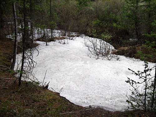
Due to the close proximity to the Wigwam TH, there were a number of people camped in the area. Probably the greatest concentration of humanity we’d see on the trip. Spent a very cold night sleeping by the somewhat glaciated Wigwam Creek. Portions of the creekbed were covered by long stretches of thick, hard ice. Not the last time we run into that on this trip.
![Wigwam Creek]() Wigwam Creek "Glacier" Thick, hard layer of ice lined the creek bed by our camp
Wigwam Creek "Glacier" Thick, hard layer of ice lined the creek bed by our camp
Awoke just after sunrise and as would be the custom on this trip, J2 hit the trail 1st. Nelson and I started about 5 minutes later at 7:45. Another clear, sunny day with some wind. Plan for the day was to hike to Lost Park, 7.5 miles to the west following the Wigwam Trail. It promised to be a much easier day with only 760 feet of elevation gain and 260 feet of loss. If the day’s hike went well, we had the option of pushing on a little further to put ourselves closer to the base of Bison Pass and the highest parts of our route that lay above and beyond the pass.
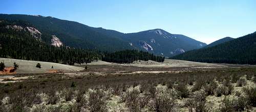
Scenery was bland by comparison to what we had seen the previous day. Mostly forest with some large granite domes that made it a little easier on the eyes and long meadows, still brown from winter. Don’t remember seeing any other hikers this day. Figured it was probably because of the closure of the Lost Park road which had been closed to protect an elk calving area.
![East Lost Park]() East Lost Park-Scenery not as spectacular as the day before but not too hard to take with the clear, blue skies overhead.
East Lost Park-Scenery not as spectacular as the day before but not too hard to take with the clear, blue skies overhead.
The day’s hike went well enough that we did decide to push on past Lost Park. With Jeff and Jonathan out in front we headed up Indian Creek toward Bison Pass. Ended up hiking another 3.5 miles and climbing 700 feet before we got to the camp that J2 had picked. I think Nelson’s “knackeredness”, to use Jonathan’s term, slightly exceeded mine by the time we rolled into camp. Our “easy day” had morphed into another tough one and we were glad to get the boots off!
Set up camp and got cleaned up a little. Weather still holding though gusty. One gust picked up my as yet unstaked tent and would have slammed it into the branches of a nearby dead tree if not for the quick actions of Jonathan.
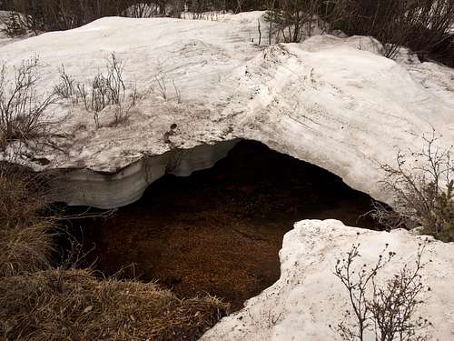
Lounged around camp enjoying the late afternoon sun. Much ice on the creek as there was at our last camp. Perhaps forewarning of another cold morning? Hit the sack early after dinner, not long after the sun set. Big day on Wednesday starting with a 700 foot climb to Bison Pass.
![Ice Bridge]() Indian Creek Ice Bridge ~ Photo by Nelson
Indian Creek Ice Bridge ~ Photo by Nelson
Frigid early morning next to glaciated Indian Creek! Everyone scrambled to put on all the warm clothes they had and it still wasn’t enough!
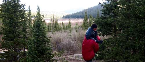
![Chillin']() Got down??
Got down??
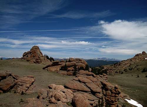
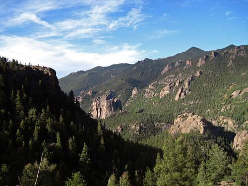
Fortunately, the sun peeked over the ridge before too long, and memories of the morning chill quickly vanished. Nelson and I were on the trail by 8, reaching the Pass in good time and taking a short break there. Proceeded east on the Brookside-McCurdy Trail from the Pass, to the high point of our trek at 11,900 feet, just south of 12,431ft Bison Peak, the highest point in the Lost Creek Wilderness.
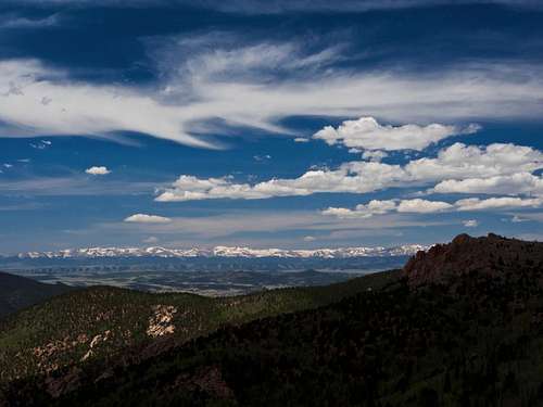
![South Park]() South Park ~ Photo by Nelson
South Park ~ Photo by Nelson
Clear, blue skies with a few “designer clouds”, as Nelson calls them, thrown in and stunning views in all directions greeted us on top. Reuniting with Jeff and Jonathan, we relaxed, rehydrated, replenished, and took a bunch of photos. The time we spent up there was amazing. Even got cell service when I climbed atop one of the rock formations and was able to call home.
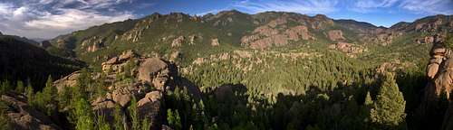
![Lost Creek Wilderness]() Lost Creek Wilderness
Lost Creek Wilderness
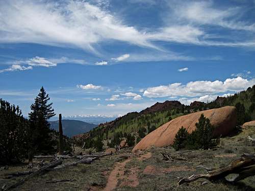
Got back on the trail and found it hard not to gaze continually at the beauty that surrounded us. Caught up to J2 at a small stream where they were getting water. While Nelson hung back as Jeff repacked his filter, Jonathan and I moved on. After a few minutes, I was on my own as the fast hiking Jonathan motored around the next bend and out of sight. Upon reaching the “pass” south of McCurdy Mountain, I stopped and waited for Jeff and Nelson. No sign of Jonathan. Before they arrived, I must admit I was a little confused. For some reason, I was thinking that I was at the McCurdy Park trail junction and was wondering why there was no junction, duh? Map reading skills must be one of the first things to go with age!! Jeff set me straight when he and Nelson showed up and then we were off, down the trail to the Park, which was still a short distance ahead.
![Southside McCurdy Mountain]() Southside of McCurdy Mountain-Brookside/McCurdy Trail, with the Sawatch Range in the background
Southside of McCurdy Mountain-Brookside/McCurdy Trail, with the Sawatch Range in the background
At the junction we went left, heading north on the McCurdy Park Trail where we soon came upon Jonathan, waiting for us. We continued down the trail, keeping an eye out for a good campsite as we went. Found one a little less than a mile farther down in a clearing by a creek, surrounded by aspens. The scenery on this part of the hike was spectacular in it’s own way. More crazy rock formations nestled amongst electric green groves of aspen.
![McCurdy Park]() McCurdy Park ~ Photo by Nelson
McCurdy Park ~ Photo by Nelson
In spite of the big climbs at the beginning, this had been the easiest day of the trip. Weather was still good so we kicked back and relaxed in camp while watching a couple groups of backpackers moving slowly up the trail.
Thursday
Much warmer night, temp probably in the 40s when we got up. Interestingly, our camp was at the exact same elevation as it had been the night before, 10,600 ft, but there was zero ice on the creek by our camp. After the last two mornings chill, we were glad for the warmth. Another beautiful day though it was somewhat hazy due in part to smoke from the Black Forest fire near Colorado Springs.
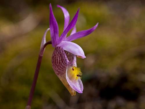
![Lady Slipper Orchid]() Lady Slipper Orchid ~ Photo by Nelson
Lady Slipper Orchid ~ Photo by Nelson
We were on the trail again by 8 and to start with it was all downhill, to the tune of 1,400 feet. So glad we were going down the trail instead of up! The scenery got more amazing with every step as we dropped into the depths of the Upper Lost Creek Canyon. Aspens everywhere, mixed in with rosey-hued rock formations of all shapes and sizes. Gotta think that this would be an awesome place to check out in late September!
![Tarryall Mountains Panorama]() Tarryall Mountains Panorama ~ Photo by Nelson
Tarryall Mountains Panorama ~ Photo by Nelson
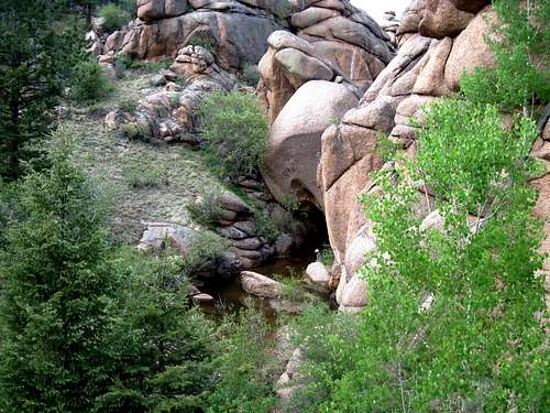
Along the trail we encountered a group of guys who shared some info about good places to camp in the Refrigerator Gulch area, which is where we were heading. J2 reached the Gulch ahead of us and by the time we got there, Jonathan had located a nice campsite. He led us down a very sketchy path, at the bottom of which we found our spot. Not far from our camp there was a place where the creek emerged from an underground grotto.
![The Grotto]()
![Lost Creek Underground]() L
LLost Creek Underground ~
Photo by Nelson
The guys went down to check out the grotto while I was still getting my tent and gear situated. I was thinking more about taking a dip in the creek but was waiting for the sun to pop back out from behind a cloud.
While the boys were settling down in a grassy aspen grove to catch up on their reading the sun popped back out and I made my move downstream, looking for a good place to take that dip. Found a good, deep spot a little ways down. It was glorious!! Water temp was bearable but cold enough to warrant a quick exit and thankfully, the sun shone just long enough for me to dry off before it disappeared again.
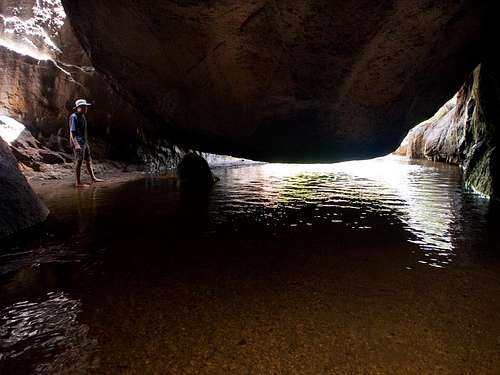
Got back to camp and decided it was time to check out that grotto. It was amazing! Walked in as far as I dared, the light being not quite good enough to see how deep the water was in places. After taking some photos I exited, thinking it might be good to return later, with my headlamp, for a better look.
![Atop a Formation]() Nelson & Jonathan atop a Formation
Nelson & Jonathan atop a Formation
Jonathan and Nelson went across the creek to climb a rock outcrop while Jeff and I started our dinners. My last dinner was a little on the light side. Wished I had had some trout to add to it. Saw some in the creek but I carried no fishing gear on this trip.
Nelson and Jonathan made it back and got their dinner made just as a brief thunderstorm rolled in. After the storm, skies cleared and we enjoyed another beautiful evening, our last of the trip.
![Refrigerator Gulch Camp]() Refrigerator Gulch Camp ~ Photo by Nelson
Refrigerator Gulch Camp ~ Photo by Nelson
Shortly after we turned in some tremendous gusts of wind blasted down the canyon, ripping some of my tent stakes out of the ground and nearly flattening Jeff’s tent. Down below, where Nelson and Jonathan were camped, they barely felt it. Our site was pearched on a flat spot about 20 feet above the creek which gave us a great view but was apparently not the best place to be when the wind gets funneled through the gulch. Got the tents resecured and crawled back in at twilite. A light rain started and way off in the distance, I could hear what sounded like another blast of wind coming. Drifted off to sleep wondering if I’d wake up in the middle of the night with a faceful of tent. Thankfully, I did not.
Friday
The air was warm and the skies were clear once again when I crawled out to greet the day. We got up a little earlier than usual to get a headstart on the day since we faced a three hour drive after our hike. Nelson and I on the trail at 7, J2 of course, being on it a bit ahead of us. A fairly short but steady climb brought us to the Goose Creek Trail junction above. Now we were back on familiar ground, having passed this way on Monday, heading north. Took a short break at the junction before pushing on.
![Looking back]() Looking back towards Refrigerator Gulch from the trail junction above
Looking back towards Refrigerator Gulch from the trail junction above
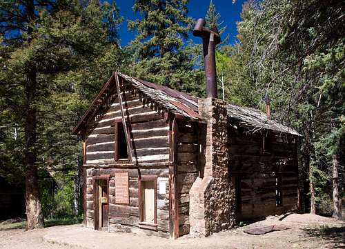
Descended for about 3/4 of a mile before getting back on the roller coaster that is the Goose Creek Trail. Took our next break at the bottom of the steep grade where the Shafthouse turnoff is located and went down to check out the site and the buildings. Pretty cool spot with a couple of cabins still standing, one of which is two-story.
![Shafthouse]() Shafthouse ~ Photo by Nelson
Shafthouse ~ Photo by Nelson
Back on the trail heading to the finish line which was still about 3.5 miles away. We were moving along at a good clip with me moving a little faster due to my longer legs and Nelson’s penchant for taking photos along the way. The last few miles of the trail ran next to Goose Creek whose clear, cool waters beckoned as the day grew warmer. Started seeing a lot more people, day hikers and campers, in the lower stretches of the creek.
As I climbed the last hill to the TH, I spied Nelson chugging up the trail below. He was moving quickly and had just about caught up to me.
Jeff and Jonanthan hi-fived us as we walked up to the cars. Lifting a few ice cold ones, we toasted our completion of a great trip and return to modern world. That first taste cascaded down my parched throat like a waterfall in the desert, just like it always does!! Ah, the fruits of civilization!
Looking back, it was a hell of a trip, into an amazing wilderness with a great group of guys. Pretty exciting stuff indeed!


Comments
Post a Comment