
-
 21075 Hits
-
 77.48% Score
-
 8 Votes
|
|
Route |
|---|---|
|
|
46.37894°N / 13.84888°E |
|
|
Download GPX » View Route on Map |
|
|
Hiking, Via Ferrata |
|
|
Summer, Fall |
|
|
A long day |
|
|
Medium hard hike (T4) |
|
|
Introduction
 Prag - the Bear's Rock |
 At Begunjski studenec |
We already have a good SP page of the northern normal ascents on Triglav by Velebit. But as these routes are very popular, I think they deserve their own pages (to be searchable) and also some more information. |
Overview

Prag Route ( in Slovenian: "Čez Prag" = "Over the Rock Step") is one of the two normal, marked routes from Vrata valley to Kredarica hut (and from there further on Triglav). It is considered a bit easier of the two (the other one is Tominšek Route), but the difference is not big. However the ascent Čez Prag is some 30 minutes longer than by Tominšek Route and a bit less attractive. Typically it's recommended as a descent route.
History. The path was built already in the 19th century by the German Alpine club. It follows old hunters passages. With the Prag rock, called also Medvedova skala (Bear's Rock) the story goes that it was named by a big bear who felt to its death over it, fleeing from Trenta (of course!) hunters.
After a majestic approach we enter the huge Triglav wall, but the path soon does a long crossing and only then climbs over a few steep rocky steps. In the rest of the main ascent it uses ledges, steep, rugged slopes and some screes. After exiting the wall on good 1900 m, first unpleasant scree slopes are awaiting us, then in the last section the ascent goes over a slanted, high karst plateau, where once the Triglav Glacier was lying. Overall a long and very scenic ascent, on which you closely touch the Triglav North Wall.
General Information
|
Difficulty: It's a hiking tour, with many places protected by steel cables and pegs. On the Swiss Hiking Scale its difficulty would be graded T4. The crux is Medvedova skala, some good 15 m high, almost vertical rock wall. There some strength is needed in arms and you should not be vertigous. However also this short ferrata section is graded only B. Don't be intimidated by the Slovenian grading (zelo zahtevna pot = very demanding path). Orientation: The route is well marked (red "Knafeljc" marks). Over the wall you should have no orientation issues, however higher, on the plateau below the glacier, be careful to follow the marks. There the path is weak and there is no distinct landscape feature to help with orientation in poor visibility. Map to recommend: Julijske Alpe - Triglav. Planinska zveze Slovenije. 1:25.000. Exposition: Some places are exposed and so not appropriate for people suffering from vertigo. Objective dangers: In Julian Alps walls the danger of rockfall is always present. On the Prag Route even more so, because the route is very frequented and not every hiker is taking care not to trigger loose rocks. Even if the route ascends over the north oriented face, in normal seasons snow rests mostly disappear till mid summer. As said, on the upper plateaus fog can be dangerous. Best season: Summer months, normally from July till October (or first snow). Gear: Good shoes and poles are sufficient. A helmet is always welcome and for less experienced hikers and children consider taking for them ferrata sets (also for the ascent on Triglav). Tour start: End of the road in Vrata valley, 1010 m. Big, parking place there (3.5 EUR in 2015). Highest point: 2515 m (Kredarica hut) or 2864 m (Triglav summit). Altitude to overcome: cca 1550 m (1900 m). Time for ascent: 5 h (6 h on Triglav). |

Route Description
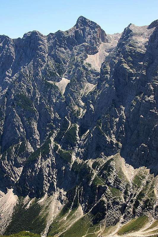
Prag route from across the valley of Vrata
Up By Vrata Valley
From the parking place you go a few minutes to Aljažev dom (hut) and then further up by the nice valley. Before entering the rocks of the Prag Route, three branchings are important. The first one is at the monument to fallen partisans-mountaineers (a huge peg), where the Tominšek route is forking left. We continue straight and so also a few minutes later, when in the woods the path on Kriški podi (through Sovatna valley) is forking right. In the SW direction you continue by the valley, the creek of Bistrica is close on your left. So you come out of the high woods, where close to the sources of Bistrica there's another crossroads. There you go left, by a more frequented path (while the right one goes on Luknja pass). You cross the creek, ascend by a short slope on the other side and you are at the entry, some 1200 m.
Over the Face
The first rocks are crumbly, not very steep and a bit unpleasant. There you meet the first protection devices and experience loose rocks. Across a small ravine and by the other side you are soon over this first rock step. There the long, flat crossing towards the left starts. The path simply follows a broad ledge, overgrown with grass and pine bushes. Not much altitude is gained there, but the views across Vrata valley are more and more beautiful. On the beginning of this crossing you will also notice week paths deterring right of the marked path. Those are being used by climbers who enter the rocks of various variants of The Slovenian Route (easy climbing over the North Wall of Triglav).
Finally, when we already came from Triglav's wall into the wall of Begunjski vrh, also our marked path turns up again. The path winds up in several turns, we are all the time climbing over some more or less steep rock steps, the rest are steep slopes, overgrown by pine bushes and grass. We first keep right and over a ravine, then steeply up again. There soon the steepest parts come. The smoothest, almost vertical rock is Bear's Rock, over which good protection devices (many pegs, cables) help us. A few other rock steps are easier. Above, the path does some crossing again and finally ascends up, reaching a small scree field in the middle of the walls. The path crosses it up and towards right, reaching below the last, again a bit higher rock step. This one is very crumbly and the narrow path, even if it's secured, again requires some additional attention. Above the step we are on some 1950 m, on the bottom of long scree slopes. The wall is below us.
Below Begunjski Vrh
To avoid unpleasant scree slopes (they are however wonderful in the descent!), the path now turns left, follwing the edge of the walls towards the east. When reaching again the steep slopes of Begunjski vrh, it turns up, joins the Tominšek path and finally attacks the soft scree field. The path keeps closely to the vertical walls and soon reaches Begunjski studenec. This is a small water source which usually has some water during the whole summer, except after long, dry periods. A true blessing in these barren rock slopes! After the water source we must continue ascending the scree slopes some 50 more meters, after which we reach another branching. Our route to Kredarica hut forks right (the left path goes to Stanič hut). Be careful not to miss it.
Over the High Plateau
Next good one hour we shall be ascending over a rugged, slanted rock desert, where we still see the remains of the Triglav Glacier. The path first crosses the lower part of the plateau, called Kotel (=cauldron). Then it continues more steeply up. It mostly avoids the remaining snow fields, winds left and right by broad gravely banks, left over by the glacier, aiming slightly towards the south west. On the right is the summit of Triglav and we must reach the saddle between it and the Kredarica ridge. From the saddle, the majority of hikers goes first left to the nerby hut, but we can also save those few minutes if we continue the same day on the summit of Triglav.