
-
 2738 Hits
-
 79.04% Score
-
 10 Votes
|
|
Mountain/Rock |
|---|---|
|
|
40.31811°N / 5.72184°W |
|
|
Download GPX » View Route on Map |
|
|
Hiking, Skiing |
|
|
Spring, Summer, Fall, Winter |
|
|
7864 ft / 2397 m |
|
|
Overview
 Cuerda del Calvitero seen from Canchal de la Ceja Cuerda del Calvitero seen from Canchal de la Ceja |
Macizo Occidental, also called Sierra de Bejar is the second highest subrange of Sierra de Gredos in central Spain. Its main summits, Canchal de la Ceja and Torreon del Calvitero rise above 2400m and thus belong to the top 20 of the whole range. To the north of these two mountains rises a flat-topped whaleback, Cuerda del Calvitero, which misses out on 2400m by only three meters. Even tough the summit of the Cuerda belongs to the highest spots of Sierra de Gredos it is often considered to be little more than a big and long north ride of Canchal de la Ceja. However, the two summits are separated by Portilla de la Ceja, a saddle where the profound (and beautiful) Garganta del Trampal ends, also one of the most popular routes to climb either of the two mountains.
 |  |  |
As said above, Cuerda del Calvitero is a whaleback of a mountain. There are steep, rocky slopes towards Ggarganta del Trampal in its south but from all other sides it can be climbed rather easily. In fact, for most climbers it is only the first stage on the climb to Canchal or Torreon, as the route towards these summits passes close to the Cuerda's highpoint. Thanks to its comparable elevation, however, views rival the ones from its higher neighbours.
 |  |  |
A much more beautiful and impressive route leads through Garganta del Trampal, the valley, which separates Canchal de la Ceja and Cuerda del Calvitero. The route starts at some 1600m entering the narrow valley. Carved by glaciers, the faces to the sides are made up from granite. While the Canchal side is near vertical, the Cuerda side is a steep slope made up of numerous blocks. In the centre of the garganta there are three lakes, hiking destinations themselves. In its topmost part the valley leads up to Portilla de la Ceja, from where a short traverse leads to the summit of Cuerda del Calvitero.
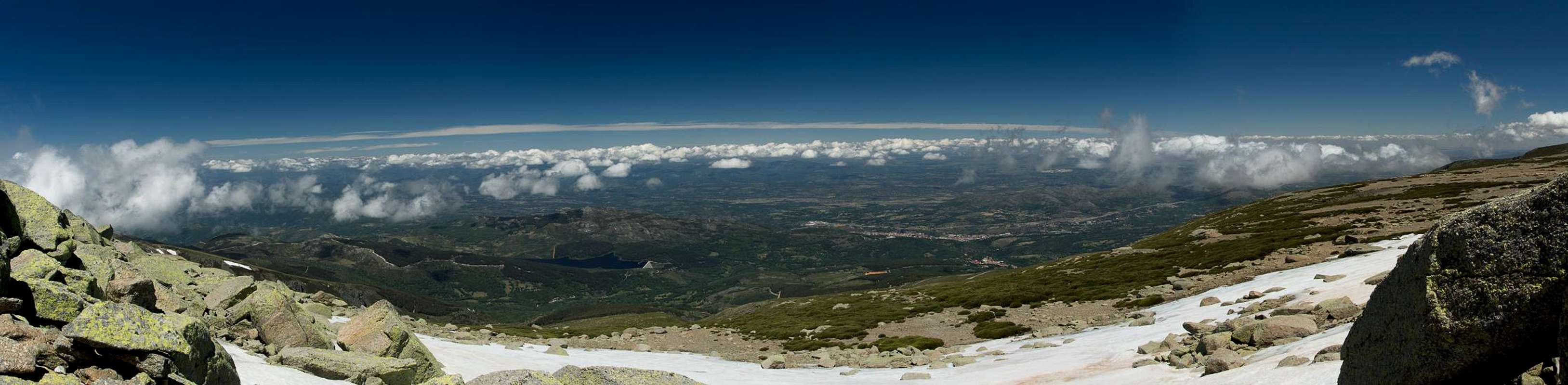  |
Located in the north of Sierra del Bejar, Cuerda del Calvitero offers far reaching views across the huge plain (La Meseta) in its north and west. In addition the whole of Macizo Central of Sierra de Gredos is aligned to the east and south of the mountain and on a fine day you can see it from Puerto del Pico in its east to the plains around Plasencia in the west.
Getting There
 Laguna del Trampal
There are two trailheads, which you can use to reach Cuerda del Calvitero: La Plataforma del Travieso in its north and Central del Chorro near Laguna del Duque in its east.
- From Madrid take motorway A-6 / AP-6 to
- For Plataforma del Travieso switch to AV-100/SA-100, direction Bejar
- At Navacarros switch to DSA-181 to Candelario
- Here switch to the mountain road to the plataforma (follow the signs)
- For Central del Chorro stay on AV-110 until you reach the exit to Solana de Ávila
Dirve through Solana, ignore the right turn to La Zarza, instead go straight to Central del Chorro
- There is a gate which you can open and close. There is a parking lot near the power station below the lake
Routes
 Cuerda del Calvitero south face
Cuerda del Calvitero is rarely the sole destination of a hike as it is very close to Canchal de la Ceja. Usually it is passed along the route from Plataforma del Travieso to Canchal. This route is straightforward as you hike up the north slopes of Cuerda del Calvitero until you reach the plateau. Orientation is easy (just go up) though the actual path (there is one) is indistinct in its central part.
 |  |  |
A much more interesting route starts at the electrical power station Central del Chorro beneath the reservoir Laguna del Duque. This route follows Garganta del Trampal all the way up to Portilla de la Ceja, the saddle, which separates Cuerda del Calvitero from Canchal de la Ceja. Along the route you pass the beautiful lakes Lagunas del Trampal beneath the big and tall north face of Canchal. From the saddle most hikers turn south for Canchal de la Ceja, joining the masses which come down from Cuerda del Calvitero to head for the same destination.
Red Tape
 Euphydryas aurinia Euphydryas aurinia |  Dactylorhiza maculata Dactylorhiza maculata |  Argynnis (Speyeria) niobe Argynnis (Speyeria) niobe |
The area around Central del Chorro is private property, even though the road gate usuallly can be opened all year round. Nevertheless, it is one of the most popular trailheads for hiking in Sierra de Bejar, since four rutes of different difficulties lead to the highest summits of the subrange, Canchal de la Ceja and Torreon del Calvitero. Garganta del Trampal has no particular preservation status but shows a wonderful flora which deserves to be respected.
Accommodation
Rather than direct you at specific websites I would encourage you to do a Google search. Most of the websites are commercial and some of them require additional fees.Google search for accommodation near Sierra de Gredos
Weather Conditions
 Crossing a creek in Garganta del Trampal
Maps & Books
Maps
I have only been able to find an overview map, scaled 1:135000
- Parque Regional de la Sierra de Gredos
Adrados Ediciones
1 :135000 / 1 :25000
ISBN : 978-8492236367
Books
- Sierra de Gredos: Circo de Gredos – Valle del Tiétar – Valle del Jerte
B. Plikat
Rother Verlag
ISBN: 978-3-7633-4716-2 (Spanish)
ISBN: 978-3763343812 (German)