
|
|
Route |
|---|---|
|
|
34.35860°N / 117.7636°W |
|
|
Hike |
|
|
Half a day |
|
|
Walk-up |
|
|
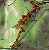
Approach
Park in the Vincent Gap parking area, which is about 50 miles from I-210 in La Cañada and five miles west of Big Pines.
Route Description
Start at the wooden sign that says "Baden-Powell Trail - 4 Miles". The route is easy to follow, thanks to the signs along the way. You are going to navigate 41 switchbacks on your way to the summit. These are the most switchbacks of any trail in the San Gabriels. You will have gained 2,800 feet by the time you reach the top.
 |
Essential Gear
Be sure to bring enough water.
Miscellaneous Info
If you have information about this route that doesn't pertain to any of the other sections, please add it here.