Overview
Volujak is BiH's second highest mountain. It is made up of a long ride lying parallel to the Maglic range. At its south eastern end, and on the tip of a corner of BiH territory reaching into Montenegro is the highest peak, also called Volujak. Indeed three-quarters of the summit can be said to be in Montenegro!
The walk to the summit from BiH is exceptional; starting from Prijevor, passing the beautiful Trnovacko Jezero/ lake and then through a winding valley to the imposing highest point of the Volujak ridge - which is carefully hidden from the views from the lake.
Getting There
The approach is from BiH, to hike to Volujak from Trnovacko Jezero. Ascents from Montenegro are possible, but I am not quire sure how.
The M-20 highway from Foča/Srbinje (Фочa/Србинје) to Gacko (Гацко), which crosses through Tjentište (Тјентишсте), is the starting point for the approach to these peaks. It can be reached by following the M-5 highway easy out of Sarajevo.
1) Approaching from Foča/Srbnije, as you enter Tjentište on the M-20, take a left turn opposite the lonely ‘Energo Petrol’ petrol station.
2) Follow this road ignoring minor turnings to the left and right. At first the road is tarmaced but it then turns into a dirt track. After around 7 km the road is again tarmaced and a small car park emerges to your right. This is Dragoš Sedlo (Драгош Седло), with its monuments to fallen Partisan heroes. Here if you wish you can park the car and follow the marked path to your right for 5 mins to taste the magic of Peručica forest and catch a glimpse of the impressive Skakovac waterfall from a well placed view point.
1) Carry on along the road for the main attractions. Continue on the same road but only for around 4km after Dragoš Sedlo (43º 18.287N, 018º 44.390E). When the road makes a pronounced U-turn to its left, there is a smaller right turn - take this right turn.
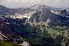
2) Follow the road for another 3 km as it dips down into the valley of the River Perucica and then up again towards Prijevor. There the road peters out a little short of some farmhouses and you will have to leave your car (you are now in the area covered by Map 5.2). Enjoy the views of Mt Maglić towering above you and part of the Volujak ridge on the opposite side of the valley.
The approach can be undertaken in a normal car with care, although the road is deteriorating in a number of sections.
Getting to the top
The start of the hike (43º17.051N, 018º43.168E) is a wide path that continues straight on from the road that you used to get to Prijevor.
1) Follow the continuation of the road in a southerly direction. After 2 km, red paint marks clearly point to a detour to the right of the main track, which takes you on to a short cut down to the meadow next to Suva Jezerina lake (often dry). Here you meet a path that comes up the valley.
2) At the southeast corner of the meadow is the continuation of the path, which takes you into the forest and up to the Trnovačko Jezero.
3) You arrive at the lake on its northwestern tip.nAround 50 meters up the hill on the western tip of the lake is a hut (43º15.072, 018º 43.283E) that is often used by the Montenegrin authorities to register visitors who have crossed from BiH into Montenegro and to police the fishing on the lake.
4) As you enter Trnovačko Jezero follow an immediate right turn in the path.
5) Follow this path up from the lake into a valley and towards some farmhouses. After only 20 mins, ignore a right turn to one of the subsidiary summits of the Volujak ridge (signed “Badnjine”) and continue to reach the farmhouse (30 mins).
6) Continue along the same path, up the valley past the farmhouses. Move on in a south-westerly direction looking for a faint path that makes its way up the valley behind the farmhouse. Continue up and along this valley over steep ground. At one point the direction of the valley changes to follow a more southeasterly trajectory.
7) Eventually you will leave this valley and reach a saddle in between the peaks of Volujak and Trnovački Durmitor (1h 45 mins), with Trnovački Durmitor now hiding your views of Trnovačko Jezero. At this saddle turn right and move south to get up to the Volujak ridge. Once on the ridge turn right again (west) to get to the summit of Volujak (45 mins).
Guide to Volujak
Follow this link if you want to buy a hiking guide to Bosnia & Herzegovina, which includes walks on Volujak.
https://www.buybook.ba/shop/index.php?custid=&gid=21&sgid=51&cpid=&linkToPids=&cbr=&pid=39242&kategorija=3


gimpilator - Nov 29, 2015 1:06 pm - Hasn't voted
Coordinates GlitchI just stumbled onto a strange glitch which corrupted the location of numerous pages and listed them all at the same point in southern AZ, USA. Please fix the lat/lon coordinates of this page to the following (43.232007, 18.716400) and I'll be happy to remove my "needs updates" vote. Thanks!