
|
|
Area/Range |
|---|---|
|
|
43.16000°N / 18.44000°E |
|
|
7864 ft / 2397 m |
|
|
Overview
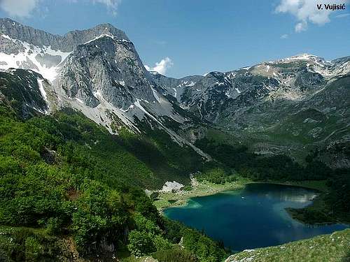 Trnovacki Durmitor & Trnovacko lake from Maglic
Maglič (2388 m) / Bioč (2397 m) / Volujak (2294 m) / Trnovački Durmitor / Vlasulja (2337 m) is one of most beautiful and most impressive mountain ranges of Montenegro. That mountain range include four large mountains - Maglić (2388 m), Bioč (2397 m), Volujak (2294 m) and Vlasulja (2337 m), and it stretches in the NW part of Montenegro, creating a natural border between Montenegro and Bosnia&Herzegovina. All these mountains are placed above beautiful Trnovacko Jezero lake and makes an extraordinary mountain scenery.
The highest peak of Maglić / Bioč / Volujak / Trnovački Durmitor/ Vlasulja range is Veliki Vitao (2397 m) - the highest peak of Mt Bioč. On the Mt Maglić the highest peak is officially Veliki Maglić (2386 m), while the highest peak of the Mt Volujak is Studenac (2296 m). Finally, the highest peak of Mt Vlasulja is Volujak (2336 m). So, exist the Mt Volujak and Volujak peak. The first one is a large mountain, while the second one is just the highest peak of Mt Vlasulja.
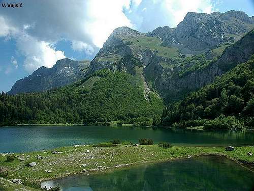 Maglić from Trnovacko Jezero lake
Maglić (2386) is the highest although not the largest mountain in Bosnia and Herzegovina and one of the most beautiful mountains of Montenegro (Serbia&Montenegro). One part of Maglić massif is placed on Bosnia&Herzegovina side, while it's second part is on Montenegrin territory. Maglić peak has two summits, Bosanski Maglić (2386 m) peak on Bosnia&Herzegovina side and Crnogorski Maglić (2388 m) on Montenegrin side, which is 2 m higher then Bosanski Maglić summit on Bosnia&Herzegovina side. But, officially, the pride of the highest summit of Mt Maglić belong to Bosanski Maglić (2386 m), even that the Crnogorski Maglić (2388 m) is 2 m higher. Montenegrin part of Maglić massif is decorated by amazing beauty of Trnovačko Jezero (Trnovačko Lake), one of the most beautiful of Montenegro.
 Maglic (2388 m)
Maglić massif is located about 20 km on the southwest from the city Foca near the border with Montenegro. On Montenegrin side, the nearest place to Maglic; is Mratinje town. The mountain is on the north and west bordered by river Sutjeska, on the southwest by mountain Volujak, on the east by rivers Drina and Piva and on the south by valley Mratinjska Uvala.
All hillsides, except northwestern, are very steep and overgrown with coniferous and beech trees. Forest line is approx. at altitude of 1600 m. Above is plateau with excellent pastures. Many summits and ridges raise from the plateau – the most important are Vučevo (Crni Vrh 1591m), Rujevac (1835m), Sniježnica (1804m), Prijevor (Makaze 1668m), Mratinjska Gora (1576m) and the Maglic; ridge itself (2388m).
 Maglic & Trnovacki Durmitor & Bioc from Volujak
The foothill and the hillsides are rich with water but the plateau isn’t. There is a spring at Dragos Sedlo (just below the road) - near the monument to Nurija Pozderac (war hero from World War II). There are springs on both Rujevac and Ulobic but it’s dry in late summer. The most plentiful is a spring in Carev Do that never dries out.
There are no permanent settlements on the mountain. Before the war, during summer, many shepherds came with flocks of sheep on the plateau but now (after the war) I don’t remember I’ve seen a single one.
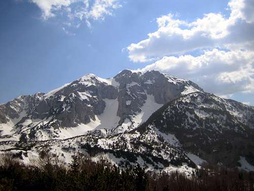
 BIOC range with Veliki Vitao (2397 m) peak
 Trnovacko Jezero
The most attractive point of Maglic is definitelly its main ridge with the highest summit. The summit is accessible only from southern side overgrown with grass and mountain pine. All other hillsides are steep, barren and rocky. The view from the summit is just marvellous – first of all to neigbouring Volujak and Bioc and Trnovacko Lake, but also to Durmitor (in Montenegro) and other bosnian mountains on north and northwest.
Trnovacko lake is particularly beautiful – at height of 1700 m, long 700m and wide 400m, squeezed among Maglic, Volujak and Bioc whose ridges slope to the lake valley. It’s open only to the north toward wooded Vratnice. Colour of the lake is amazing green-blue.
 |  |  |  |  |
Getting There
 Beautiful outlook of Maglic
 Maglic (2386 m) summit view
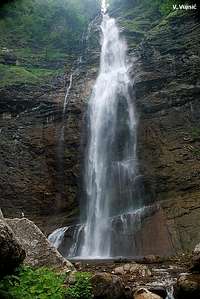 Skakavac waterfall
From Sarajevo go to Foca. Then turn to Tjentiste. Just before entering Tjentiste valley, there is a small gas station on the right. You turn on the left - tiny asphalt road leads to Maglic (unfortunately there is no any sign on the road). Only first 1-2 km of the road is aspahlted but that's not the problem - the other part is quite good too (no need for 4x4). The road is quite curved and goes through the forest. When you leave the forest you'll reach a saddle (I call it "saddle" beacuse it's a place when the road ends rising but it's more like plateau). Then slow down and concentrate on the right side of the road. You should notice a small forest road and some hut without walls - only benches and table with roof (sorry but I don't know the english term :)). Leave the car there. Follow that road (by foot of course :)) about 20-30m (meters). After these 20-30 meters, the road turns left but you keep going straight. You should notice first mountain mark on the tree - that's start of the trail. The trail is quite good marked. After 2h and 40min you'll reach the ridge of Maglic. Then turn right and you'll see the summit. The rest is history :)
Note 1: There is no water on the trail.
Note 2: There are no minefields in this area.
 Skakavac waterfall in Perucica virgin wood
 |  |  |  |  |
Red Tape
 NW impressive side of Maglic
No permit required.
 |  |  |  |  |
When To Climb
The optimal place for climbing in Maglic / Bioc / Volujak / Vlasulja range is mid June - mid October. But, prefer dry weather - some rocks over abysses can be slippery if wet. Northern approach to Maglic (2386 m)
 |  |  |  |  |
tjalfi - Jun 17, 2005 8:13 am - Hasn't voted
Untitled CommentThe easist route is, as mentioned in the text, from the south along a long grassy ridge. On this way, you'll traverse Crnogorski Maglic, the tallest point of the whole range (2388). Crnogorski Maglic looks less attractive than Bosanski (the main peak, 2386), that's why it's often neglected by climbers, even though the summit can be reached within 5 minutes from the marked trail (let alone the fact that it's the highest mountain - but of course, Bosanski is the tallest in BiH:) Besides this trail (marked well from the Trnovacko lake), there are at least two other ascent routes on Maglic. One from the Prijevor saddle (western route), one from Ulobici (eastern). Both include rocky sections secured by fixed ropes. The one from Prijevor is extremely steep and breathtaking.
tjalfi - Jun 17, 2005 8:33 am - Hasn't voted
Untitled CommentWater is really not very abundant in the upper parts of the range. One cesma is to be found a few dozen meters above the road fork at Mrkalj klade, direction Lokva derneciste. We can call it Nikola Poplasen, as somebody has painted his name on it . If you start in Mratinje (Montenegro) and take the route onto the Ulobici plateau, last water can be replenished at Police. But the Carev do spring offers not only magnificent water but also a fine place for camping with stunnig views in all possible directions.