Getting to Base Camp
![Tiedemann Glacier]() Tiedemann Glacier base camp.
Tiedemann Glacier base camp.
After 7 months of anticipation and planning, a dozen or so people coming then not coming, Shawn, Chris, Henrik and I landed on the Tiedemann glacier late Saturday night July the 14'th 2012. The drive from Vancouver, with stops took roughly 11 hours- if one was determined they could do it faster. We were lucky that a helicopter was available shortly after we arrived- Summer fires in BC lure the White Saddle helicopters away from climbers for hours at a time. Mike and Audrey King at the White Saddle ranch on Bluff lake are super helpful, they'll get ya in there, best to show up ready to go cause things happen fast around there.
The Bravo Glacier
![Bravo Glacier]() On the Bravo Glacier looking down to the Tiedemann Glacier
On the Bravo Glacier looking down to the Tiedemann Glacier
The route up the Bravo glacier starts off easy and progressively gets more and more challenging. Zipping up to Rainy Knob is pretty straight forward, after that you will slow down as more and more crevasses appear. You will most likely need to belay someone across a few of them, as terrain and snow bridge condition merit caution. Note: we climbed in Mid-July, the snow pack that year was slightly above average, though the weather up until July wasn't all that hot. What we dealt with is probably an average scenario for that time of year.
Higher up on Waddington
![High Camp on the Wadd]() Sunset as seen from high camp, 3700 meters on Waddington
Sunset as seen from high camp, 3700 meters on Waddington
Once past Rainy Knob the terrain became a little more challenging, there were two sections that we pitched out: one was a crevasse above Rainy Knob the other was the Headwall just below Bravo Col. Once past Bravo Col the terrain once again turns mild with a few cold holes here and there. We once again encountered some difficult terrain high up on the hill, a crevasse just below the Tooth and Mt. Waddington required us to climb down into and up the other side. Note: there were other options: a steep snow back with a HUGE drop off or a long walk around could have got us to our high camp as well.
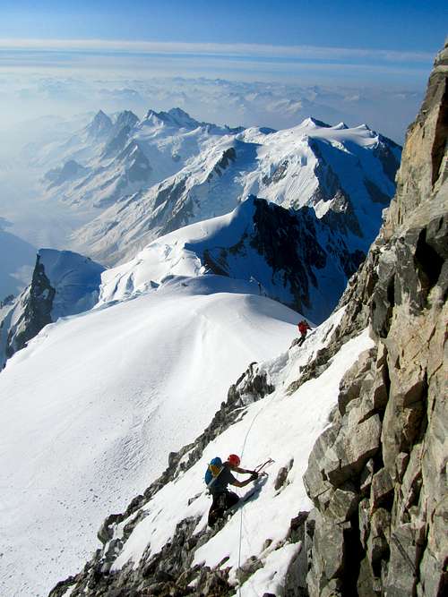
The fun begins
![Mt. Waddington Action]() Chris belaying Henrik below the Tooth.
Chris belaying Henrik below the Tooth.
The climbing begins once you leave the upper glacier just below the Tooth. This is a mix between 4'th and low 5'th class terrain. We pitched out the last bit before the Notch.
![Climbing on Waddington]() Chris and I climbing on Waddington: Henrik on lead/bealy/ and picture duty.
Chris and I climbing on Waddington: Henrik on lead/bealy/ and picture duty.
Once at the notch you'll get a good dose of exposure, and you'll enter the chimney on the South East side of Mount Waddington. The book rates this as 5.7. We opted to climb up and to the right out of the Chimney as the left exit looked caked with snow and rime. The Mazama exit is rated 5.8, as is the direct exit. The rock is loose in spots here, so be careful!
![Climbing in the Chimney]() Climbing up the Chimney.
Climbing up the Chimney.
The views from Waddington are second to none. This area has a South American/Himalayan feel to it. Definitely worth the time and effort!
![High Camp View]() The views while on the Mountain are second to none.
The views while on the Mountain are second to none.
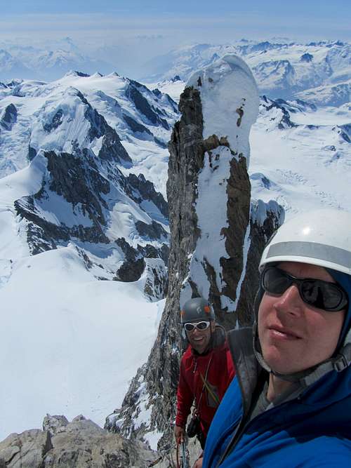
High up on the route, above the SE chimney you will enter easier terrain. Here you see Henrik and I with the Tooth behind us...If I ever go back I'll definitely climb the Tooth!
![High on Wadd]() Henrik and I high up on the Wadd with the Tooth behind us.
Henrik and I high up on the Wadd with the Tooth behind us.
Not sure what the terrain looks like when there is no snow and ice, it could be low 5'th, for us it was mixed terrain that required rock pro, ice pro and snow pro.
![Near the top]() Closing in on the Summit
Closing in on the Summit
We all summated Mt. Waddington, there wasn't much room up top. This was the most exposed summit I've ever stood on! The view from the top is breathtaking to say the least. All in all it took us three days to climb up there. Day 1 from the Tiedemann to just below the Headwall on the Bravo Glacier. Day 2 from just below the headwall to high camp. Day 3 summit climb. This is the view from the main summit looking at the North-West Summit.
![View from the top]() Looking North-West from the main summit.
Looking North-West from the main summit.The Route
We ended up pitching out 6 pitches, if conditions were better we might have scrambled more. The route was mixed, MI 2, with some rock at 5.8- though most felt 5.6 or 5.7. Yellow is the descent line down from the notch onto the upper snow pack. From high camp to the summit and back took us 13 hours. In better conditions we would have been much faster....though the ice and mixed climbing made the trip that much more enjoyable!
![Route up high]() Pitched climbing up high.
Pitched climbing up high.Rack Used
We used a standard alpine rack:
-set of nuts
-5 pins- knife blades, bugs, and an angle
-full range of cams up to #3 Camalot, we doubled up on .75 and #1
-5 screws, 10cm, 2-13's, 16cm and one 22cm (for v-threads)
-2 pickets
-alpine draws (12 in total), be sure to bring a handful of double length slings for horns.


Comments
Post a Comment