
-
 5102 Hits
-
 85.36% Score
-
 20 Votes
|
|
Mountain/Rock |
|---|---|
|
|
49.97417°N / 126.19028°W |
|
|
Hiking, Mountaineering |
|
|
5253 ft / 1601 m |
|
|
Overview
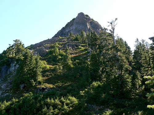 Waring Peak Waring Peak |
Although Waring is lower than its immediate neighbours to the north, Mt Alston and Sutton Peak, it doesn’t enjoy the same high access from nearby industrial roads. Once upon a time such roads went as high as ~ 1,000 metres on the southwest ridge – just below the old growth in fact. However, the access roads have long ago been deactivated lower down and debuilt higher up, such that the climber must now start from barely 600 metres elevation.
Waring Peak SW aspect
Waring sees few, if any visits, perhaps as a result of the comparatively difficult access compared to Alston and Sutton (not that these mountains see that many folk either). On a recent visit, we saw one or two ancient scraps of flagging in the old growth and none elsewhere. We saw no cairns, other than that on the summit, and certainly no trace of foot traffic. There is no summit register to record who, if anyone, has been this way.
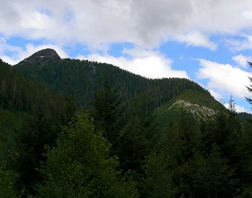
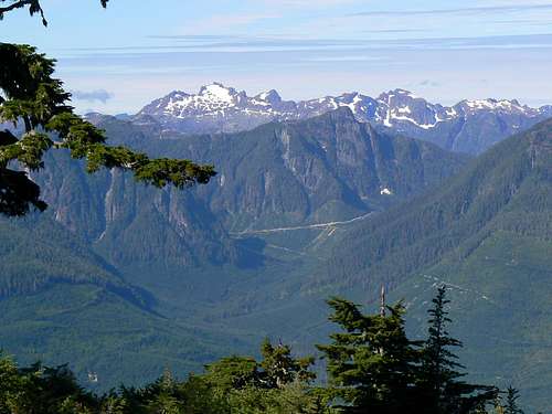
The Sutton Range typifies the topology of the Island north of Campbell River. Steep basalt pinnacles tower above the White, Gold and Nimpkish Rivers and their subsidiary watersheds far below. The eastern faces are particularly precipitous and Waring is no exception to this rule. After climbing the relatively gentle southwest side of the mountain no unprepared visitor could fail to be surprised by the precipitous east face dropping away almost vertically 300-400 metres to the bench below.
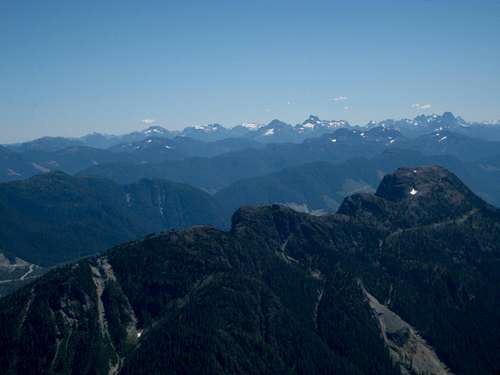
Situated above the Gold River valley and south of the pass over to the White River to the east and the Nimpkish Valley to the west, Waring offers stunning views in all directions. The mountain is the closest of the Sutton/Alston/Waring trio to the unique and wonderful Alava Bate Sanctuary and offers particularly superb views of this special place. To the northeast the south aspect of Victoria Peak completely obscures Warden Peak – the latter being clearly visible from Alston and Sutton. The Haihte Range shimmers on the horizon to the northwest as do the high peaks of northern Strathcona Provincial Park to the south.
Waring Peak is named for Harry L Waring, a cook with the 1947 BC survey party led by Alfred Slocomb. Waring was hurt in the field during the course of the survey and later died of his injuries.
 Alfred Slocomb's original 1947 BCCS survey monument still in the summit of Waring Peak Alfred Slocomb's original 1947 BCCS survey monument still in the summit of Waring Peak |
Getting There
Vancouver Island can be reached directly by air from Toronto, Vancouver, Seattle, Calgary, Edmonton and recently from San Francisco to Victoria and by ferry from Port Angeles to Victoria on The Coho and on BC Ferries from Vancouver to Victoria or Nanaimo. Public transport on the Island is notoriously poor and anyone arriving by air would be advised to rent a car.The approach to Waring Peak requires you to negotiate steep, narrow, decommissioned industrial roads with deep water bars. Once off the main Nimpkish Road a high clearance vehicle with 4WD is absolutely mandatory.
There are no restrictions, such as gates, on the approach roads but it would be a good idea to check with Western Forest Products Ltd for the latest conditions.
Waring Peak can be reached off the Nimpkish Valley Road which itself can be accessed from Gold River to the south and from the inland Island Highway 19 to the north.
For the Gold River approach make your way to Campbell River at the end of the freeway section of the inland Island Highway 19. Take highway 28 west towards Gold River. After 40km you will enter Strathcona Park at Elk Portal. Exactly 1 km further on highway 28 makes a right turn over the bridge at Buttle Narrows. Take this turn and drive all the way to Gold River. There is no gas beyond Gold River so make sure you have enough to cover at least 150 km. From Gold River follow signs initially to Tahsis and Woss. Roughly 2-3 km from town cross the Gold River and immediately take the right fork to Woss (the left goes to Tahsis). This is the Nimpkish Valley Road and pavement soon ends after this point. Drive 27 km from the Gold River bridge - following signs for Woss if in doubt - and find unmarked Waring Road on the right at N49 58.363 W126 15.610. A hundred metres further north, just over the bridge, is the well signed “Alston Road”, the access for Mt Alston as described in that mountain’s SP page.
For the north approach continue through Campbell River on Highway 19 following signs for Port Hardy. Pass through Sayward Junction and 11 km before the turn-off for Woss, turn left at the sign for Schoen Lake Provincial Park. All roads from this point are gravel. Almost immediately after turning onto gravel the road forks. Take the right branch signed for Gold River. This is the north part of the Nimpkish Valley Road. Drive 36 km from Highway 19 – following signs for Gold River if in doubt - and find Waring Road on the left.
Lock in 4WD and proceed briefly northeast up Waring Road before the road swings round to the southeast and enters the valley southwest of Waring Peak.
Drive up the valley a total of 4.5 km from the main line until you reach the obvious impasse at N49 58.115 W126 12.867 where the bridge has been removed. Park here. Elevation is about 650 metres.
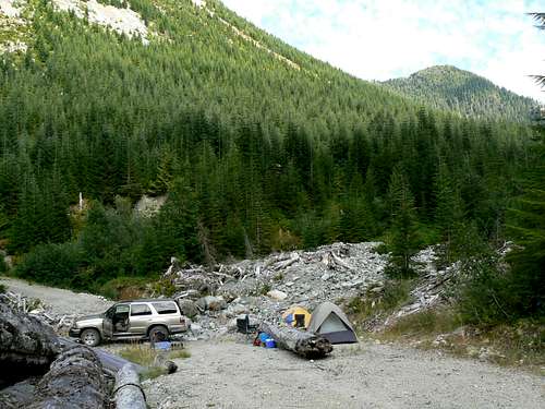
Waring Peak. Start/Camp
Above you to the northeast you will see the lines of the debuilt roads that once gave high access to the southwest ridge. To the southeast you can see what appears to be recent logging right up to the crest of a saddle. More on this later.
Approach and Southwest Ridge Route
From the start point cross the river and walk up the road for 5 minutes to the bottom of a steep, eroded gully at N49 58.000 W126 12.618. Turn left off the road and climb about 250 vertical metres up the gully to the debuilt road above. The going is very loose, especially at the top and some might appreciate a helmet during this phase. Initial gully approach Initial gully approach |  Debuilt road leading to bush Debuilt road leading to bush |  SW ridge old growth SW ridge old growth |
Turn left at the top of the gully and follow a faint game trail along the debuilt road, around the crest of the ridge and right to the end of the road at about N49 58.237 W126 12.449 where it terminates at a nice cocktail of logging slash and thick bush.
Endure a brief B4 thrash through the vegetation, contouring southeast, before emerging into the old growth. Once in the big trees, swing round gradually onto a northeasterly course in order to intersect the southwest ridge proper.
 Top of SW ridge Top of SW ridge |  Traverse left to summit route Traverse left to summit route |  Scrambling the summit block Scrambling the summit block |
When you’re sure you’re on the ridge simply follow it northeast up to the alpine and a flat bench below the summit block with a nice col below to the left and a superb view of the Alava Bate Sanctuary to the west. The ridge is steep in places but, once in the old growth, the going is open and friendly. We left a few, discreet but well placed and certainly sufficient flags for future visitors. Please don’t add any more!
From the bench below the summit block descend briefly to the northeast and traverse off in the same direction under the steep ground above in order to intersect the skyline ridge ahead. Turn east at whatever point you feel comfortable and scramble rock slabs at Class 3 or heathery gullies onto the summit ridge. Continue east around the narrow ridge crest to the summit.
 Summit ridge Summit ridge |  Approaching the summit Approaching the summit |  The summit of Waring Peak The summit of Waring Peak |
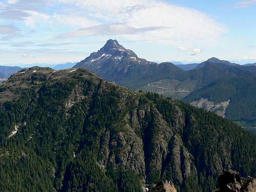
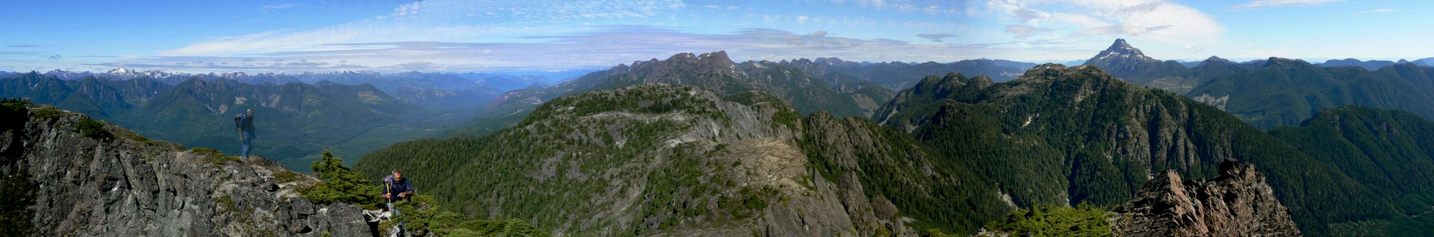
Enjoy the views! Across the White River Valley to the east, Victoria Peak dominates the view but don’t obscure the mainland Coast Mountains beyond. To the north Sutton Peak and Mt Alston seem to blend together from this aspect – although they are well separated in reality. To the south are the mountains in the north part of Strathcona Park: Rambler Peak, Mt Colonel Foster and Elkhorn amongst them. As the eye swings round to the true west it picks out the Alava/Bate Sanctuary, further north the Haihte Range and beyond to the summits in the far north Island as far as visibility allows.
Descend the climbing route.
The Alava Bate Sanctuary from Waring Peak
Total distance: ~ 7 km
Net elevation: ~ 950 metres
Total elevation: ~ 1,000 metres
Ascent Time: ~ 3-4 hours
Descent Time: ~ 2.5-3.5 hours
As always a MapSource/Garmin tracklog is available for the asking for the approach and summit routes. Just send me an email or PM.
Alternate Route

Logged saddle possible alternate
From the summit of Waring we were able to get a good look at those aspects of the access roads below that we couldn’t see from low down.
What chiefly caught our attention was the logged saddle referred to above that we could see above and to the southeast of the removed bridge.
Beyond the steep, loose access gully described above, the deactivated approach road goes right into the logged saddle. From there a short hike through slash and old growth appeared to offer quick and easy access to open alpine terrain which led around northeast and then northwest to the east side of the summit block. We made a detour over to the east side of the summit area and verified that this side could be climbed from the bench below.
Anyone going this way and trying this option is encouraged to post details. It would make for a fine circular route combined with the southwest ridge and would avoid having to do the loose gully on the way up and on the way down.
Red Tape and Safety Considerations
Absolutely no red tape.There’s nothing resembling a formal trailhead and an intentions system simply doesn’t exist in this neck of the woods. Make sure, therefore, that you have left a detailed trip plan with someone responsible. The RCMP and the appropriate SAR agency will respond in an emergency but it is up to you to have the mechanism in place that will initiate the call-out process if it becomes necessary.
There is no cellular service anywhere on Waring Peak. If this is a concern, equip your group with a satellite phone.
Camping
Waring is easily accomplished as a day trip. You might want to get an early start and a car camp may be called for. If so, I’d establish it right at the end of the approach road by the removed bridge. The road is inactive and there’s unlikely to be anyone coming this way. There’s not much of a view, except for the southwest ridge above, but it’s a pleasant enough spot. The river is right there for water and bathing so there’s no real need to haul a barrel in with you.Bear and cougar frequent the mountains and forests of Vancouver Island. Proper back country methods – isolating food out of reach, cleaning up all cooking scraps, good toilet practice etc – are all absolutely essential in this and all backcountry areas of the Island.
Victoria Peak from Waring Peak
Useful links
For more information refer to Island Alpine – A Guide to The Mountains of Strathcona Park and Vancouver Island, Philip Stone, Wild Isle Publications, 2003, ISBN 0-9680766-5-3. Note that IA describes a route that was only viable prior to the high roads being debuilt.For general backroad information and directions get hold of a copy of Backroad Mapbook. Volume III: Vancouver Island
Weather
Nearest point current conditions and forecast.West
East
Summit Panorama
  |