Overview
Working at a ranch in Montana just down the road from the Anaconda Range in the summer of 2001, I had viewed Warren Peak numerous times. I would often hike
Huff Puff where I could view Warren Peak in all its splendor a few air miles distant.
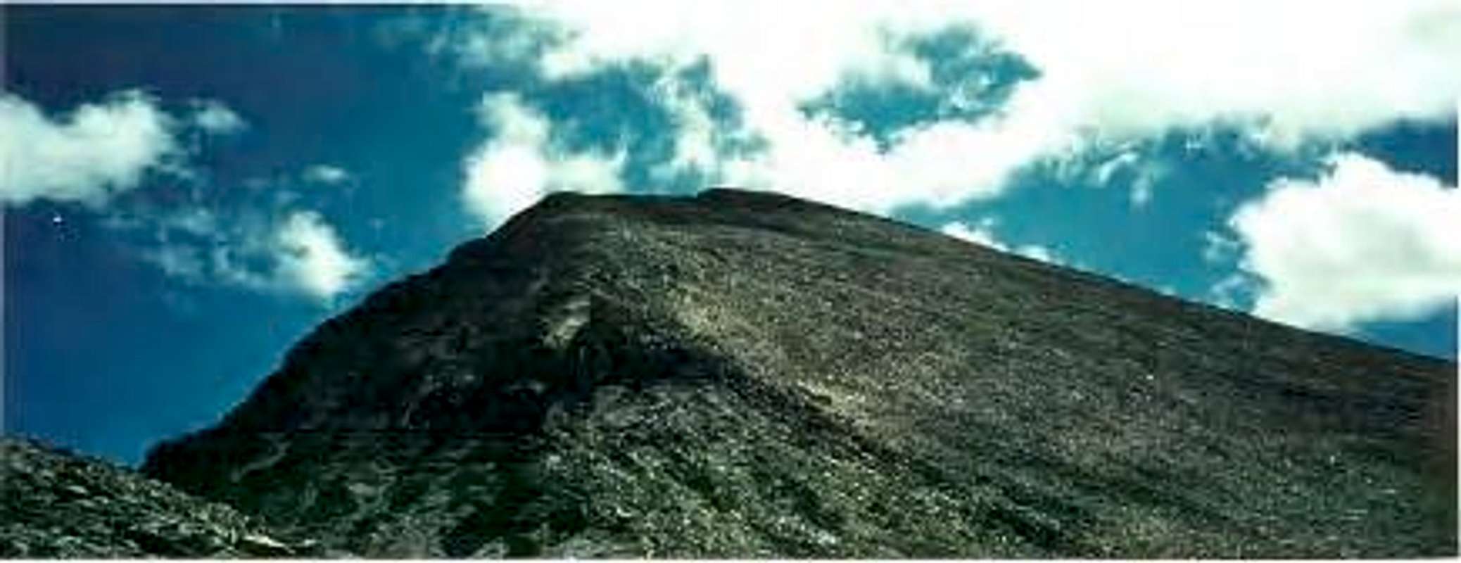
![About 12 miles down Moose...]() View of Warren Peak from the summit of Huff Puff
View of Warren Peak from the summit of Huff Puff
I decided to tackle the peak on a good weather day in late July with a husband of one of my co-workers. This was the first time I climbed Warren Peak. I would climb it again with a co-worker a couple weeks later.
Climbing this mountain was truly a wonderful experience, and I will explain the trips below.
Trip #1
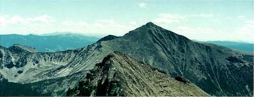
![View of a smaller Pintler...]() East Pintler Peak 9486' from the Edith Lake Trail
East Pintler Peak 9486' from the Edith Lake Trail I had the good fortune of living only four miles from the trailhead to Warren Peak, which is located at the end of Moose Lake Road, 30 miles from the nearest town.
The trailhead is large, with trails heading in multiple directions. The trail to Edith Lake is actually a main trail that goes to both Edith Lake and Johnson Lake. There is a register at the start of the trail.
My hiking partner and I took off on a morning with perfect weather in late July. The trail is long, mostly in the woods for the first hour. We hoofed it up to the first overlook, about 2.5 miles in to catch our first view of the mountains. We both had been to Edith Lake before, so nothing on the trail was a mystery.
Not far past the first overlook is where the trail shoots off to Edith Lake. We were making good time as we took this turn, but we had only hiked up 300 feet or so at this point. We had nearly 4,000 feet of elevation left to gain to reach the summit.
As we hiked up the now steep trail, about two miles to Edith Lake, we were welcomed with open views of the mountains. Still reeling from fires in the summer of 2000, the woods were red.
At Edith Lake, we took a break. We still had over 3,000 feet left to climb. Fortunately however, we had knocked off 5 miles or so of the trail. We had about 2 miles left to go, but it was pretty darn steep.
Since neither of us had climbed Warren Peak before, we had to strategize. As the trail comes into the lake, you can see the base of Peak 9452, which shares a ridge with Warren Peak. There is no trail, so we had to figure out our route by ourselves. My hiking partner said, "we need to head up this mountain first". He was right.
It wasn't long after skirting up the steep woods that we reached a series of boulder fields. Soon there were only on boulders which we had to scramble up. As we climbed on, Edith lake got smaller and smaller until it was non-existent. The trees were smaller and less dense until we finally got up high and could see the Bitterroots, 50 miles to the West.
The steepness was getting to me. Not an experienced mountain climber yet, I was taking steps that were too large. My hip was aching and getting worse the further we went up.
It wasn't until about 1700 feet above the lake that we finally took a real break. I told my partner about my hip and he suggested I take shorter steps. Fortunately, there would be no elevation gain for awhile. We had to skirt around the summit of Peak 9452 to reach the ridge. This did prove somewhat tricky since the boulders were quite big, and sloping downward. My foot got caught at one point, but I managed to extricate myself. Not long after I took care of this little matter, we reached the ridge and could see the final stretch of Warren Peak in front of us. About 1300 feet to go.
![The Bitteroot Mountains (50+...]() Bitteroots
Bitteroots![View to the summit of Warren...]() The final stretch to the summit
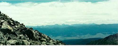
The final stretch to the summit![View of the valleys and the...]() View from near the summit
View from near the summit
Climbing up the summit was fun. We headed straight up the boulderfield until we couldn't go up any further.
![On the main part of the...]() Heading up the boulder field
Heading up the boulder field
Once at the summit, views were spectacular. We found the USGS marker and took a lunch break. It had taken us about 4 1/2 hours to reach the summit, with about 20 minutes of break at Edith Lake.
![It feels so good to be on top...]() On Top
On Top![Warren s higher neighbor,...]() West Goat Peak, 10,793' from the summit
West Goat Peak, 10,793' from the summit![View down the North side,...]() View north from the summit
View north from the summit
The way down was confusing. We did not head down the same way we came up. Rather we went straight down into the woods and headed back in the direction of the lake. We ended up climbing over fallen trees, and negotiating endless different routes before our descent was successful. When we returned to the lake, my hiking partner got naked and cooled off in the lake. He was pretty liberated I guess. Even in the middle of Montana, I am not taking off my shorts because I do not want to get my underwear wet as I walk six miles back to the trailhead! Ever try walking 6 miles with wet underwear? Overall, this was a successful trip. Below is a description of my second trip which had some different experiences.
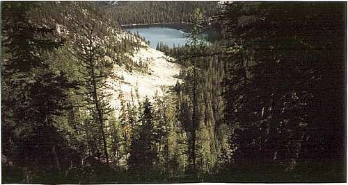
![The first time I climbed...]() View of Edith Lake from the bushwhack down.
View of Edith Lake from the bushwhack down.Trip #2
Two weeks later I returned to Warren Peak with my co-worker. He was an interesting guy. He went to prep school at Choate in Connecticut and got kicked out for doing cocaine. He moved to Alaska with a determination to climb Denali. Failing that, he traveled around for awhile, seemingly trying to find himself. Believing himself to be akin with nature, when he came to the ranch to work for us, he slept in the woods the first two nights.
As for the hike, I was more confident the second time out. I knew the way to the summit, and I knew how to avoid pain in my hip. The weather was decent for 75% of the way up. But as we reached the ridge below the final ascent, the storm clouds rolled in. We knew it was only about 40 minutes to the summit from here, and we decided to soldier on.
Once at the summit, we saw the extent of the storm. Individual rain clouds poured and thundered onto surrounding peaks. We counted the thunder as it got shorter and shorter. The lightning was right over our heads. Now right in front of my face came a CRACK! We sat with our backs to the rock shelter at the summit; chunks of hail falling on our laps. We sat there and watched the storm around us.
The view was amazing, and for some reason I felt a strange calm. There we sat at 10,463 feet, high up in Montana's rocky mountains, lightning coming down all around us, and we felt completely at ease.
After about twenty minutes the rain subsided. We were now safe for descent. One problem though: The rocks were slippery. My co-worker was speeding down the rocks, while I struggled to navigate them. Finally he slowed down to wait for me as we entered the woods. We headed back to Edith Lake and back to the ranch. Another hike; another memory I will keep forever.
Comments
No comments posted yet.