-
 8573 Hits
-
 77.48% Score
-
 8 Votes
|
|
Route |
|---|---|
|
|
47.56054°N / 12.92439°E |
|
|
Skiing |
|
|
Spring |
|
|
Most of a day |
|
|
strenuous |
|
|
Overview
Watzmann Hocheck is the nothern summit of the huge Watzmann ridge in the Berchtesgadener Alps in southeastern Bavaria.
Best time for skiing normally is april and may which means that there is normally no snow in the Ramsau valley. You have to hike up ( and down !) about 500 meters until you reach the spring snow line. But the fun above normally is big enough to make this effort worth.
Getting There
The trailhead is located at Wimbachbrücke between Ramsau and Berchtesgaden along the Bundesstraße 305. There is a parking area and several restaurants.
Local bus lines 845 and 846 from Berchtesgaden railway station stop at Wimbachbrücke.
local bus connections
Route Description
From Wimbachbrücke (610 m) follow the route to Watzmannhaus. As there is normally no snow in april or may you have to hike with your skies on your shoulders or fixed at your backpack. Follow the forest roads up to Stubenalm (1203 m). Look out for snow roses (Helleborus niger), they are quite abundant on the northern slopes of Watzmann.
Snow starts normally at Stubenalm. Put your skies on and follow the slope south of Stubenalm, leaving the forest road, which heads southeast to Falzalm and Watzmannhaus - the wrong direction for our skiing adventure.
The slope south of Stubenalm winds up between the trees up to the (snowy) meadows of Gugel Alm (deteriorated) and the Gugel, a minor summit in the now more and more prominent northwestern ridge of Hocheck.
The Gugel, right above the timber line and halfway up the ascend, is a good place for a rest. In front you can see the Watzmanngrube between the northeastern and the northwestern ridge of Hocheck, the first giving way to the summit from Watzmannhaus in summer and autumn.
From Gugel follow the northwestern ridge closely. You have to overcome a narrow, rocky and steep part of the ridge first. Sometimes the skitrack is icy and steep, sometimes on this part of the ridge there is nearly no snow left so you have to hike up with your skies on the shoulders.
Soon enough the ridge becomes broad an less steep. The route zigzags up until it reaches the northwestern summit slope. You can zigzag up this slope directly from the end of the northwestern ridge or traverse the slope to the southeast, where you reach the northeastern ridge which becomes now the north ridge of Hocheck. Follow this ridge, its easy to do with skies and you will have more and more spectacular views. Deep down to your left is Watzmannkar with the Kleiner Watzmann and the Watzmannkinder, to your right is impressive Hochkalter with its eastern walls and avalange gullys.
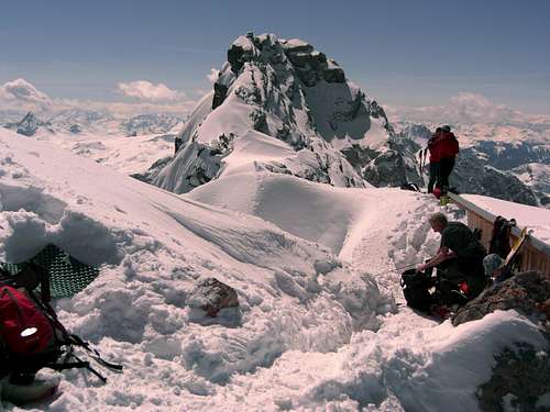
You reach a nearly horizontal part of the north ridge and after a while (normally you will start now to ask yourself: where the ... is the summit???) Hocheck summit is visible. A last steep ascend leads you to the summit cross and - south of it - to the little summit log cabin, which was build new - in 2007 I think.
Please don´t (ab)use it as a toilet - it should give shelter during bad weather.
The views to north, west and east are spectacular. South of Hocheck is the towering, impressive Mittelspitze, the highest point of the Watzmann ridge. In April and May the ridge is still snowpacked and I never saw footprints leading to Mittelspitze in this season.
With good snow, downhill Hocheck is pure fun. Traverse to the summit slope an curve down the summit slope till the upper beginning of the northwestern ridge. There a ledge on the eastern / left side of the beginning ridge gives access to Watzmanngrube. Normally there are enough skitracks to lead the right direction. Go down and traverse the lower Watzmanngrube to the Gugel.
If snow or avalange conditions are not good follow the northwestern ridge downhill to the Gugel, this will be more safe!
From Gugel follow the slopes of the ascend route through the woods down to Stubenalm.
At Stubenalm the forest road waits for your boots and after an hour or so you know: those ski boots are definitively not made for walking !
But it was pure fun !!!
Essential Gear
Full ski tour equipment including your avalange gear.
Remember: Hocheck is 2651 m high and it can be very cold and windy up there. With bad weather and / or dense fog the upper parts of the route are not easy to find - better turn around and come again !
Difficulty
Difficulty: DifficultReasons: Long and demanding ascent (2.000 m of altitude difference); steep ascent parts; steep and exposed downhill parts
Grades:
Beginners:
easy ski-hikes with moderate altitude difference, easy routes and simple downhill slopes
Advanced:
Ski hikes for the more experienced, due to higher altitude differences and/or longer and more demanding routes including steep or exposed parts and steeper downhill slopes
Difficult:
Only for experienced ski hikers and mountaineers; high altitude differences (> 1.500 m), long and demanding routes including steep and difficult route parts and/or rock scrambling and/or parts with crampons / ice axe to get on a summit; steep, exposed and / or narrow downhill slopes
The difficulty rating shall give you a first advice about how demanding the ski route is. It is my personal rating. The reasons for the rating are given in the description. They are effective for “normal conditions” like good weather, Normal snow conditions and a moderate avalanche danger. Due to bad conditions (weather, snow, avalanches) a lower grade can tend to be more difficult.


