Overview
One of the more challenging routes on an otherwise straightforward mountain with long class 1 ridge routes, the Yawner Gullies offers climbers a sustained snow and ski route in a remote mountain wilderness. The approach to and from the Willow Creek trailhead require a hike over two 12,000’ saddles on the approach and return from the mountain, which can make this route more physically demanding than other mountain routes with limited uphill climbing on the descent. While considered one of the easier 14,000 ft mountains in Colorado due to the gradual rate of ascent on its standard routes, do not underestimate the length of time and physical stamina this route may require particularly in adverse weather conditions or snow.
Getting There
The approach from the town of Creede, Colorado is straightforward. Past the town of Creede lies Willow Creek road, a canyon dirt road that leads 7.5 miles to the Equity Mine site. There is a parking area directly below the Equity Mine, easily identifiable by mining equipment along the side of the road, as well as a 4 wheel drive road that continues on up to the Willow Creek trailhead.
Route Description
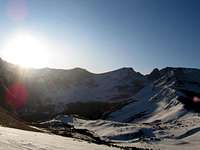
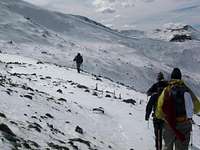
From either the Equity mine parking area or parking are just below the two markers identifying the Willow Creek trailhead, hike approximately 1 ¼ miles past the Willow Creek trailhead due north to a wooden sign indicating an intersection with the Colorado trail. Take a right at this sign and head east up to the top of a small saddle ¼ mile away. From this point you should be able to seen San Luis Peak to the Northeast, with Point 12,562 in the foreground and three jagged thirteeners: point 13,155, point 13,935 and point 13,285 to the southeast on your right.
![Approaching the three 13ers]()
![The standard path to the upper saddle]()
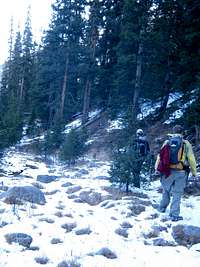
From the initial saddle, a clear trail splits either across to the left, down a ridge, descending into the Spring Creek bed through trees, or to down to the right across towards a lower saddle on the right shoulder of point 12,562. The Yawner gullies can be accessed by either route, although the route the to the right across the saddle of point 12,562 is the more gentle, if not more direct, route and is part of the standard South Ridge route on San Luis Peak. This access trail can be difficult to locate in snow.
![Spring Creek Basin below San Luis Peak]()
![Traversing the Talus to the base of Yawner Gully]()
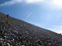
If approaching to the left (west) of Point 12,562, descend to the floor of Spring creek and resume hiking east once past the low western shoulder of Point 12,562. Upright poles identify a trail along Spring Creek, but gaining the Yawner gullies on San Luis peak will require a departure from this trail, possibly bushwhacking, up to a faintly defined trail system in trees and talus on the north side of point 12,562. Traverse along fairly stable talus for Colorado 14ers along the backside of point 12,562 until you are able to see a gully reaching a low saddle to the right and a moderately steep gully to the left heading up towards the summit ridge. Take the gully directly to the summit ridge. It can be climbed in either snow or talus conditions.
![Heading up Yawner Gully]()
![Final Section of San Luis Peak s South Ridge]()
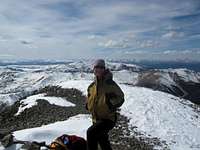
If approaching from the standard South Ridge route, gain the upper saddle of 12,562, once past the saddle round a cirque beneath the three 13ers to gain the saddle at the base of the South Ridge of San Luis Peak, then descend to the visible start of the Yawner gullies across talus or snow. Once again, climb directly up the gully to access the South Ridge. Once atop the South Ridge from the Yawner gullies, the path to the summit is a little over ½ mile over very gentle Class 1 terrain.
Descend the South Ridge route if you wish to avoid a more strenuous hike out.
Essential Gear
In firm snow conditions an ice axe and crampons are mandatory. Sunscreen and glacier glasses in winter and extra water in summer are important things to remember on this route. Snowshoes and/or skis and skins are also recommended in late Fall, Winter or Spring snow conditions.
Map, compass and GPS are advised. Unless in completely dry conditions, trails and routes are not obvious.
External Links
Add External Links text here.

 4573 Hits
 70.83% Score
 1 Votes