
|
|
Area/Range |
|---|---|
|
|
44.45107°N / 116.12875°W |
|
|
Hiking, Mountaineering, Bouldering, Scrambling, Skiing |
|
|
Spring, Summer, Fall, Winter |
|
|
8322 ft / 2537 m |
|
|
Overview

Tripod Peak Snowstorm
The West Mountains are one long, high granite ridge, interrupted here and there with a few more dramatic peaks. In the high country there are many beautiful meadows as well as a few mountain lakes that would make great destinations for hikers. This range is also the source of the Weiser River.
Although it is located in an area know for its outstanding outdoor recreation this range is seldomly a destination for climbers as the peaks do not rise to great heights. In fact, the highest peak in the range, Snowbank Mountain is only 8322 ft. tall. Regardless of this there is still quite a bit of elevation gain from the valley to the crest of the range (about 3500 ft.)and the all of the major peaks do actually reach above treeline. Snowbank Mountain and Council Peak both have the distinction of making the Idaho prominence list at #29 and #69 respectively.
The main crest of the West Mountains stays consistently above 7000 ft. with a number of peaks above 8000ft. Even without great height the West Mountains still manage to be quite dramatic especially in the spring and early summer when the peaks are still capped with snow and the valleys are green and full of wildflowers.
The mountains are made up of Idaho Batholith granite and could offer some good climbing here and there. The tall granite peaks are surrounded by lush, green forests on the lower slopes. Though not as dramatic as, for example, the Sawtooths the West Mountains still offer some carved and glaciated summits. All of the peaks have many non-technical routes but there are possibilities for technical climbing on some of the exposed granite faces.
This area receive an incredible amount of snow and is thus a mecca for winter recreation. Snowmobilers and skiers frequent this area, somtimes well into June in the higher regions. The West Mountains are also home to the Tamarack Ski resort near the town of Donnelly.
The range is managed by the Boise National Forest in the southern portion and the Payette National Forest in the North.

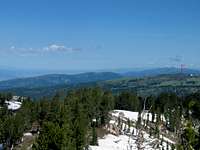
Tripod Peak from Smith's Ferry, ID.
Peaks
There are 5 peaks above 8000 ft. 4 of which are named. There are also multiple peaks above 7000 ft. and at least 6 are named. Nevertheless I have included a few of the more prominent unnamed 700 footers along with those that are named.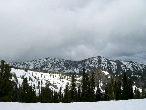
Snowbank Mountain
8000 Footers
Snowbank Mountain
Snowbank Mountain is a twin summited peak. The west summit is the highest and sits at 8322 ft. The East Summit is slightly lower at 8211 ft. There is a road in excellent condition that goes all the way to the top of both summits where the FAA keeps a radar facility.
Granite Peak
Granite Peak is about 1 mile South of Snowbank Mountain and sits at 8273 ft. The Snowbank Mountain Road goes just below the summit on the West. The top is only about a 5 minute walk from the road.
Council Mountain

Council Mountain from Snowbank
Peak 8116
Peak 8116 is a nice peak about 1 mile South of Granite Peak. It sits directly west of Blue Lake at the head of Fawn Creek. It can be easily reached from Blue Lake or from the Snowbank road by following the main ridge south from the road when it reaches Granite Peak.
Tripod Peak

Tripod Peak
7000 Footers
Collier Peak

Collier Peak
Gem County High Point
Gem County High Point
Peak 7881
Peak 7881 Is on the Ridge between Granite Peak and Tripod Peak. It is a rather sharp summited mountain and can be climbed by leaving the Snowbank Road and following the main ridge South for about 2 miles.
Wilson Peak
Wilson Peak it 7865 ft. high and is about 1.5 miles northwest of Snowbank Mountain. It is a little bit West of the Main crest and is easily hiked From the Snowbank Road via FST-135.
Lone Tree Peak
Lone Tree at 7835 ft. is located in the northern section of the range and sits over Hubbard Basin to the West and Poison Creek to the East. It is best accessed by taking FR 218 into Hubbard basin and following the trail where the road ends. The trail goes just below the summit.
Lookout Peak
Lookout Peak is about 6 miles North of Snowbank and 3.5 miles north of 7971. It stands at 7820 ft. and can be climbed from FST-133 coming from Snowbank or from the Big Flat road to the North. The trail passes to the West of this peak so you will need to leave the trail and scramble to the top.
Gabes Peak
Gabe’s Peak Is a small peak to the West of Snowbank Mountain. It is southeast of the lake, Gabe’s Bathtub and is 7665 ft. tall. A broad flat area called Wilson Meadows separates it from Snowbank Mountain. It is easily climbed from the Snowbank road by leaving it when it nears Snowbank’s summit and going directly West across Wilson Meadows and up it’s rocky knob.
No Business Mountain
No Business Mountain is a tri-summited mountain, the center summit being the highest at 7340 ft. It is best accessed from the west via FR 245 up the Middle Fork of the Weiser River and Red Ridge Road. The road goes all the way to the top of the mountain where a radio facility is.
Getting There
The best access from the East is from ID 55 which runs from Boise North to New Meadows where is joins US 95. From the West access is from US 95. Council Mountain is best accessed from the City of Council via Cottonwood Road or from the East via Anderson Creek Road in Donnely. Access is easily gained to the central portion on the range via the Snowbank Mountain Road. To get on the Snowbank road turn West off of Highway 55 at the Cleak Creek Station south of Cascade onto Cabarton Road. This road will eventually cross a bridge. Just after the bridge turn left at a large red barn and you will be on the Snowbank Road. This road is gated until May 31st.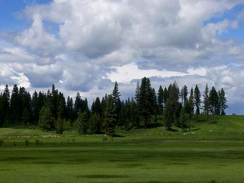
Cabarton Meadow
Red Tape
The lower portions of the mountains and especially the valley floor are all private lands. Make sure you know where you are. There will usually be signs posted along roads to let you know. Where private land ends and National Forest property begins. Also since much of the Eastern part of Long Valley is a state park you will need to pay an entrance fee of $4.00 (last time I checked) to enter the park. It is possible to get into the mountains without going through the park by using the Snowbank Mountain Road.Weather

Camping
The West Mountains offer some superb camping opportunities prtly because Lake Cascade State Park is nestled up along the mountains' eastern edge. There are numerous campsites available within the state park ranging from primitive sites with no water or fire pits to full RV hookup site with water and electricity. The park fee is $9.00 for a simple undefined primitive camping permit. This means you can camp anywhere within the park except established sites. A developed site with restrooms and a fire pit and table but no RV hookups is $12.00 and the works for an RV is $22.00. For more information of the park and fees click visit the Cascade Lake State Park website.The Boise National Forest and Payete National Forest also offer exceptional camping opportunities. If you are on federal land you may camp anywhere. Make sure that you follow Leave No Trace principles.
The Boise National forest operates 3 camprounds on the West side of Cascade Lake in the West Mountains. It also maintains 5 campgrounds at Sagehen Reservoir southwest of Tripod Peak. The nightly fee is $10.00 for each. Click here for more information.
External Links
For information about Valley County Click here.Here is a link to the Tamarack Resort website.
Probably the best source of information about the West Mountains is of course Tom Lopez's book Idaho A Climbing Guide.

A June Snowbank on the Snowbank Road.