
-
 2855 Hits
-
 75.81% Score
-
 6 Votes
|
|
Route |
|---|---|
|
|
39.13540°N / 105.3294°W |
|
|
Hiking, Trad Climbing |
|
|
Spring, Fall, Winter |
|
|
Most of a day |
|
|
easy hiking |
|
|
5.7 (YDS) |
|
|
1 |
|
|
Overview
This hike takes you to the base of the summit spire. The base on the approach.
Getting There
 The route from the road
“Tick Dome” is accessible from the west via FS 211, also known as Matukat Road. This road can be accessed from CO 67 from the north or from Park County 77 from the south. High clearance is recommended in dry conditions and 4x4 would be a must in snowy or wet conditions.
From Denver, take Hwy 285 south to Pine Junction, Hwy 126. Head south down to Cheesman Trail (22 miles, approximately 40 minutes). From there, take a very sharp right hand turn (270 degrees!) as it turns to a dirt FS road. Follow this road (FS 211) west and south another 15 miles (30 minutes minimum). This is also named "Goose Creek Road" and alternately, "Matukat Road". Park at the broad shoulder at the designated parking area, almost due west of "Tick Dome".
From the parking area, you can take either of the two ridges discernable in the topo. They both involve about the same amount climbing and the same distance. The northern keeps it at easy class 2, the southern can potentially involve some easy 3rd scrambling and rock walking.
Once at the base, you can circumnavigate the entire summit boulder. Be very careful, as you soon are exposed to 50'+ fall potential. Do NOT walk on hard rocky surfaces with water and decomposed granite BB's around - you cannot stop, and a fall would really ruin your day. There is a great flat area for camping or picnicing right at the base of the final summit block. Not sure if there is a rappel line or not, but the 3 known/published routes on Tick Dome would likely top out near this area. To get back to the river, back track down to the trail in the valley, and follow it to the river.
To climb Ticked Off, circle around to the east face. The prominent off-width crack is easily visible.
 Whoah! How do we get up that?!?
Carefully scramble up the loose, rotten granite past rotting blocks to the base of the crack. This is about 30' of gain, about the same distance. Be careful to mind the plants somehow surviving on this rock.
Route Description
Unfortunately, there isn't much to say. There are 2 ways up on the east face, which is the easiest route.The route, Ticked Off, goes at 5.7-, with 2 committing moves, followed by a nice stem/chimney.
 Just above the difficulties.
 Key steps.
 Pete rockin' the off-width.
The stem/chimney is a nice bit of friction work. It flares wider the farther out you are (and tighter the farther in). The rock is very licheny. A tall spotter can be useful in this location. The entire bit of work is only 30'. After reaching the belay station, hop, skip, and jump across the gap to the north, and then circle around to reach the summit.
 Dad crossing the gap.
An alternate with similar (worse?) fall potential exists to the left (south) of Ticked Off. It is a smooth, rounded face problem. No gear potential exists here at all. It is another free solo. The holds are thinner, and again, lichen covered. The fall to the left (south) goes to 60' pretty quickly. The anchor is again about 30' above the base of this route.
There are 2 other workable off-width lines on the S and the N faces, but they are protected by junk rock and delaminating flakes. There also appears to be 2 very good cracks, again on the N and the S sides, but they are well above my climbing ability at 5.10+ trad. Both appear to require #5 and larger cams (north side) and #2 and bigger (south side). Likely awkward finish on the south hard route. The north hard route appears to end nicely on the the summit.
North side route. South crack coming into view.
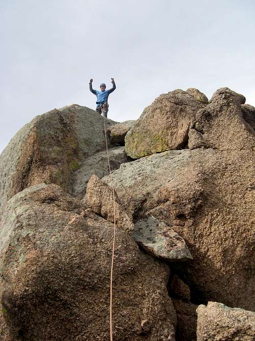 Sarah standing tall.
Essential Gear
Good sense (questionable) and comfortable scrambling and climbing skills are necessary to attempt Ticked Off. A helmet is highly recommended. A 30m rope is necessary to get down off the boulder, as is a harness and a rappelling device. We used a very thin lead climbing rope (8mm). An 8' sling can be used to sling the rotten boulder on top of the pitch. You can also bring your P.A.S. and a locking carabiner and clip the recently installed gear. As far as pro... well, there isn't really a good placement for gear. You could probably actually get 1 piece in, if you had a 12"+ Big Bro. Otherwise, it is pretty much a free solo. You should also protect the belayer with another long sling, which can be girth hitched at the bottom of the crack.For those simply interested in hiking to the amazing viewpoint or base of the summit boulder, one should plan on the usual hiking accoutrements (good boots, hiking poles for those that prefer them), a hat, sunscreen, sunglasses, WATER, and food. Because you are VERY FAR from anywhere, be sure to tell people where you're going, and you estimated time of return. There is no cell phone service in the area. The nearest help is at the Lost Valley Ranch, a good 4+ mile hike from anywhere along this route.
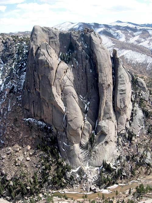 One of the baddest peaks in Colorado.