
|
|
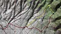
Route |
|---|---|
|
|
38.38301°N / 105.94516°W |
|
|
Hiking |
|
|
Spring, Summer, Fall, Winter |
|
|
Half a day |
|
|
Class 2 |
|
|
Driving Directions
 Driving route
Driving south on US-285, turn east at an unmarked dirt road approximately 4.6 miles south of Poncha Pass. This road requires a high-clearance vehicle soon after the turn from the highway. Turn right at a signed fork between the Rock Creek (FS-980) and Deckers Creek (FS-948) roads. Continue on to another signed junction that marks the fork between the North Rock Creek (FS-980) and South Rock Creek (FS-982) roads; turn right for the South Rock Creek road.
Here's where things get confusing with the extra roads all about; a GPS with waypoints isn't a bad idea. Generally, seek the most beaten paths, and you should do okay. You can also try to identify your surroundings because you'll want to make sure that your road makes crossings of both Rock Creek and Yankee Creek. It'll then parallel cottonwood-tree-lined Yankee Creek on its east side before making a second crossing of Yankee Creek. Sparse parking is available until you enter the forest. Otherwise, enter the forest and continue on to the junction between FS-980 and FS-982.
Alternately, you could take the left turn at the North and South Rock Creek fork and follow that road all the way to the 980/982 junction. I haven't personally seen this part of the road, so I don't know its condition.
Route Description
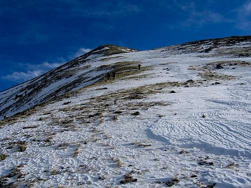 Hiking on Hunts Peak's west ridge
RT Distance: 5.4 miles
Elevation Gain: 3430'
This route is an excellent idea during the winter and spring seasons because of its great access, western exposure, and short round trip distance.
From the junction between FS-980 and FS-982, hike the South Rock Creek road northeast into the drainage. The road climbs steeply and then rounds about a ridge and leaves South Rock Creek to enter its small tributary's drainage north of Point 12,042. Just after the road takes a major switchback, leave the road and climb southeast 1000' to the crest of the minor north spur of Hunts Peak's west ridge. Once you gain the crest, you'll get your first view of Hunts Peak. Hike this spur ridge south until it joins Hunts' west ridge.
From here you have another 1000' up Hunts' gentle west ridge to the summit. Return via your ascent route.