
|
|
Mountain/Rock |
|---|---|
|
|
38.38301°N / 105.94516°W |
|
|
Fremont & Saguache |
|
|
Hiking |
|
|
Spring, Summer, Fall, Winter |
|
|
13071 ft / 3984 m |
|
|
Hunts Peak Overview
 Hunts Peak
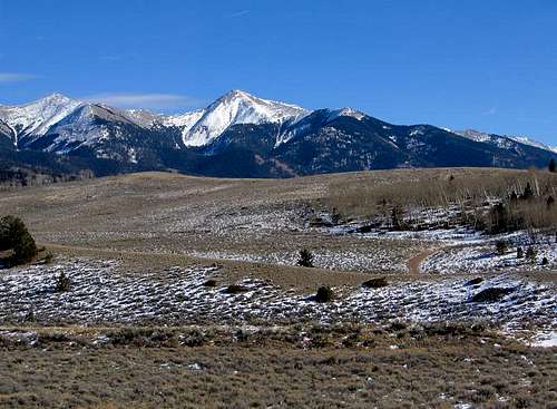
Shapely Hunts Peak is the northernmost 13er in the Sangre de Cristo Mountains and the second tallest Sangre north of Hayden Pass. It's the most distinct and prominent-looking Sangre peak that you can see from the north in the Arkansas River Valley.
The peak, Colorado's 594th highest, offers excitement year-round. During the winter and spring months, it's a great idea to attempt it by its west ridge. In the northern Sangres, the range is highly assymetrical; the range crest is much closer to the San Luis Valley than it is to the Wet Mountain Valley on the east. Consequently, you can begin your hike rather close to the summit when deep snows have made the eastern approaches inaccessible. The Sangres receive a great deal of afternoon sunshine on their western aspects and feel the brunt of the prevailing winds, so the snowpack is typically less on the western side of the range. Other western possibilities include a traverse from Simmons Peak or UN 12,401 which lie north of Hunts.
During the summer and early autumn, the more dramatic and scenic approach is surely from the east. Glaciation was a major factor in the shaping of the Hunts Creek drainage and carved a fantastic-looking ridge that splits the Hunts Lake basin from the unnamed basin north of Red Mountain. Climbing Hunts from the east is a major endeavor, however, because there's no public access from the most ideal starting point, Howard Creek, of which Hunts Creek is a tributary. Starting from the Bear Creek Trailhead, it's nine miles on trail just to reach Hunts Lake! From there, it's still another mile and a quarter to get to the summit.
Extended loop superhikes are also possible by starting at the Kerr Gulch Trailhead, hiking up to Bushnell Lakes or Stout Creek Lakes, traversing the range crest north to Hunts, and returning via Hunts Creek and the Rainbow Trail. These superhike options involve greater than 8000' of elevation gain, so they're only an option for the committed!
Red Tape
Hunts Peak is located within the Sangre de Cristo Wilderness. Typical wilderness restrictions apply. Contacting the managing agencies (see 'Mountain Conditions') is the surest way to get up-to-date information.Mountain Conditions
The US Forest Service is your best bet for determining current snow conditions and gathering other such information. The Saguache Ranger District (719-655-2547) of Rio Grande National Forest is responsible for the Sangres west of the range crest. The San Carlos Ranger District (719-269-8500) of San Isabel National Forest is responsible for the Sangres east of the range crest. Another good contact number for the east side is the Westcliffe Ranger Station (719-783-2079).For weather information, the National Weather Service is a good place to start:
Hunts Peak experimental point forecast
astrobassman - May 6, 2016 9:08 pm - Hasn't voted
Gate Closed at 285 from 3/15 - 5/15 every yearI learned this the hard way today. Hiking from 285 makes Hunts feel like more of a typical Sangre 13er day though (miles and elevation wise).