Approach
Take US Highway 395 into Colville and watch for the turnoff to State highway 20 in the middle of town (3rd Avenuue) Turn right at the stoplight and follow this road to Aladdin Road prior to reaching the airport. Turn north on Aladdin road and head for Leadpoint, 33 miles away. Leadpoint is not much more than a wide spot in the road and consists of a few homes several miles beyond Deep Lake on road 9445. In Leadport, turn right onto the signed Silver Creek road , #4720
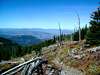
and it will soon turn into FS road 7078 at 1.5 miles. Soon after the National Forest border (you'll cross a cattle guard), bear left uphill at fork staying on #7078. Turn right (east) on road #300 (6.2 miles). Continue to small trailhead at end of road #300 (9.8 miles). Road #300 is single lane and has a few ruts and bumps but is passable by passenger car (barely) although a higher clearance vehicle is preferable. You'll reach a small TH, large enough for just a few vehicle. FS trail 117 begins from here. Your first real view of Abercrombie Peak is found in the early going of road #300
Route Description of Western approach
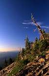
Trail #117 is t he most common approach utilized to summit the peak. From a small TH (see above) at the end of a rough 3 mile portion of road 300, a wide trail zig zags from an elevation of around 5100 feet and climbs 2200 feet to Abercrombie's summit in 3.2 miles. A small stream is available early on but after about a half mile, you will not find any water for the rest of the trail in late summer. (August-September). At 1.4 miles, trail #119 from the Silver Creek TH joins in from the right. Continue left at this junction and follow the trail another 1.8 miles until it reaches the summit. (Look for the USGS marker) The trail is shaded for well over 2/3 rds of the way and is a pleasant hike, even on sunny days. The final half mile of the trail reaches above timberline and you get an alpine feeling. Not far from the final portion of the trail, the Flume Creek trail, trail #502 climbs up from the east to join the main trail. (more on this trail in a moment) The upper portion of the mountain is a delightful flower garden during the early part of the summer.
Essential Gear
No special gear needed for this one. Nothing technical to deal with as you have a trail all the way to the summit.
Miscellaneous Info
If you have information about this route that doesn't pertain to any of the other sections, please add it here.