
|
|
Route |
|---|---|
|
|
48.92830°N / 117.4589°W |
|
|
Hike |
|
|
Half a day |
|
|
Class 1 |
|
|
Approach
This is best approached from Metaline Falls. Going north on highway 31, watch for milepost 13 and just beyond it turn left on Boundary road, road #2995. Go 3.7 miles to road #350 and turn onto it. It'll pass through a powerline corridor and stay on this road for 7 1/2 miles to the end of the road and the TH. This is a narrow and pretty rough road, suitable for high clearance 2WD vehicles but not for a low slung street rod. The road is getting worse each year and you might want to carry a pair of loppers for pruning the encroaching bushes. Parking is suitable for several vehicles at the TH and you could camp there if necessary.
 |  |
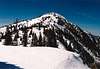
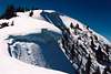
Route Description
The TH is at 5125 feet and is pretty much a straightforward trail most of the way. It is 4 miles one way and I'd allow for about 2 1/2 to 3 hours to climb the almost two thousand feet of elevation that you will gain in order to stand on the summit. The trail is numbered by the FS as #502 but the locals refer to it as the Flume trail. Near the summit, just a few hundred yards shy of it, this trail meets up with #117 (described on the main page), coming from the other side of the mountain.
Summary: Round trip 8 miles Elevation gain 1900 feet with a few ups and downs and a few switchbacks. Trail condition is good.
 |  |  |  |
Essential Gear
Good hiking shoes and bring your own water as there is none en route.
Miscellaneous Info
If you have information about this route that doesn't pertain to any of the other sections, please add it here.
Klenke - May 1, 2005 10:22 pm - Hasn't voted
Route CommentI'm a little curious why it's called the Flume Creek Trail. My mapbook shows the "trailhead" for it beginning at the switchback here (3,900 ft). Passing by there last Tuesday I noticed no such "trailhead," just an old overgrown spur. The road continued up to your trailhead at 5,120 ft. I wonder if the Flume Creek Trail is really another trail all together and the trail to Abercrombie via its East Ridge (the one you describe here) is called something else. Hmmmm?
Dean - May 1, 2005 10:53 pm - Hasn't voted
Route CommentOne of the books I have called the 5120 spot the Flume Creek TH. Why it is named that may simply be based on the proximity to the road of Flume Creek. I hadn't seen the 3900 spot marked anywhere as a TH. What was the condition of the "road" at this early time in the season?
I'm in Utah right now (motel connection) and will check the book when I get home. My guess is that it was in the "Washington's Wild Areas" book where I saw the name. I will double check that. Your pics are great.
Klenke - May 1, 2005 11:19 pm - Hasn't voted
Route CommentYou're probably right on the naming. It just seemed odd to me.
Road was in pretty good shape. I just got stymied by a little bit of snow way down at 3,600 ft so had to walk it. The upper part was all snow covered but there were no huge washouts evident.
I'll be sending out a TR soon to those of you who care about all those 2000P peaks up thattaway.
Klenke - May 1, 2005 10:30 pm - Hasn't voted
Route CommentNote that there is a spring shown on the trail here. I left the trail for cross-country snow travel before getting there (up the minor ravine 0.4 miles to the east of there) so don't know how good this water source may be--especially in summer. I think you should probably mention it is there but may be dry. There was also a small source in the aforementioned ravine I climbed up but I expect it will be dry by late summer in a normal snow year.
Newtonbb - Oct 21, 2020 10:35 am - Voted 10/10
Excellent Private HikeThe 8 mile or so logging road listed in the description can be fairly rutted and partially blocked. The trailhead indeed only has room for a of couple cars. The hike is top notch. I saw no other people which was great. Great views! Suggest calling ahead to ranger station as one time I went it was closed due to a nearby fire. No way to know in advance except a posting on the entrance to the 8 mile road. I'm going to make this a regular hike and take some visitors from Ukraine next time.