
|
|
Route |
|---|---|
|
|
42.47130°N / 112.655°W |
|
|
Hike |
|
|
Half a day |
|
|
Walk up |
|
|
Approach
This is from the front page and represents the best way to get to the TH
From I-86, take Idaho state highway 37 south for 20 miles and look for the signed Big Canyon Road, which has both a county road sign and a BLM sign. Turn east on this wide, well-graded road. Follow it as it enters the canyon and becomes steeper and rougher, but remains easily passable in 2WD with normal clearance all the way to the trailhead. At 9.0 miles you'll top out at a saddle where there is a junction with the signed Bull Canyon road heading down to the right - continue up on the main road. At 9.3 miles reach the road's high point, at a shallow saddle at about 7350'. Park here.
Route Description
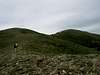
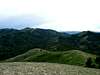
From the saddle, go left just a short bit up the road (north) until you find a spot that is adequate to pull off (a jeep road exists but may be too problematic for 2WD) so it would be best to walk it to the top of small peaklet, not more than a couple of hundred yards. When you get to the top of the small peaklet (7400 ft) hike towards Deep Creek Peak but first you'll have to contend with quite a few ups and downs through forest and brush before you get to the open ridgeline that you can follow easily all the way to the summit.
There are a few rocky and or brushy bits in the first mile or so, but there are reasonable use paths through the worst of them. Stay near the crest of the ridge as much as you can as after the first mile, the hike is mostly an open ridge walk with excellent views. At the summit we found the "Knox" benchmark and two small registers. According to register entries this peak has been ascended on horseback and motorcyle from Bull Canyon Ranch, which would be down the south ridge. The terrain is such that almost any approach you might take will probably go well but private property issues should be considered from the other directions.
Distance: 5 miles roundtrip
Elevation gain: 2000 feet (some ups and downs both ways)
Thanks to Dan Robbins for the following route map.

See his Trip Report and pics HERE.
 |  |  |  |  |
Essential Gear
No special gear needed for this walkup. Make note of where you park your vehicle so you don't wander down the wrong drainage on the way back. Stick to the ridge and you shouldn't have any routefinding problems but I always GPS where I park.
Miscellaneous Info
If you have information about this route that doesn't pertain to any of the other sections, please add it here.