![Wheeler from 93]() Wheeler from 93
Wheeler from 93![Wheeler from 93]() Wheeler from 93
Wheeler from 93![Wheeler from Sacramento Pass]() Wheeler
Wheeler
Having been thwarted by the weather on Saturday, 9/27, I turned my attentions to North Schell peak on Sunday. After summiting I drove back to Baker and enjoyed a few hours of R & R before settling in early. My reasons for a
relatively early start the next morning were twofold: I wished to avoid the afternoon thunderstorms, and I intended to make some good progress on my drive back to Boston, which would begin the moment I returned to my car.
![From NPS overlook]() Wheeler from overlook
Wheeler from overlook
Despite this new determination, I lazed around and checked out probably an hour later than scheduled. The sun rose behind me, above Notch Peak to the East in Utah as I drove the National Park road up to the trailhead. The air was crisp, cool, and comfortable, and like most of my other hikes this trip, the Fall aspens were in full bloom. The difference here on Wheeler was that they were much more abundant, especially along the road leading to the trailhead, and the early morning sun gave their yellow hues that extra little tint of radiance.
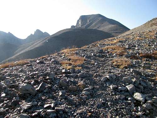
The Wheeler Peak Trail is excellently maintained, making for a very easy ascent, and in my opinion is one of the best trails I’ve had the privilege to tread upon. It would be a great introductory hike for an outdoors novice if it weren’t located so far away from anything and everything resembling even the farthest outposts of modern civilization. The magnificent Jeff Davis/Wheeler cirque peeks at you behind the aspen leaves for the first few stretches of the hike, then reveal itself in its full glory as the trees give way to some open meadows a little more than half a mile in.
![Wheeler]() Wheeler
Wheeler
If you start at the Wheeler Peak trailhead (as opposed to the campground trailhead, which is farther down the road and involves a few hundred feet of additional elevation gain), it is approximately a mile before you reach the Alpine Lakes Loop Trail. Follow the signs for Wheeler to take a left. You stay on the Alpine Lakes Trail for about 0.2 miles before another sign prompts you to take a sharp right. From here the next stop is the summit.
![Bald Mountain]() Bald Mtn Bald Mtn |
![Sun and shadow]() Cool shadow Cool shadow |
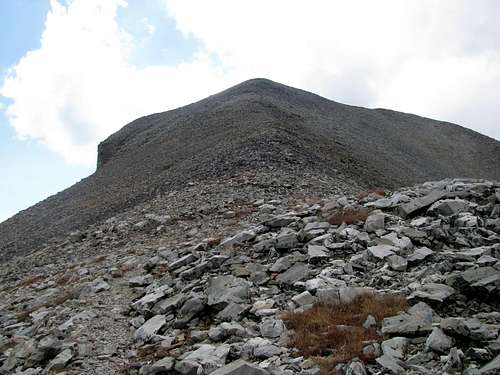
The trail traverses around some open meadows before crossing the last grove of evergreens and reaching timberline for good. You eventually gain the saddle between Wheeler and its neighbor to the north, Bald Mountain. It then heads up the broad slope as Wheeler disappears from view. A few hundred feet later, the peak reappears, and after some more climbing you reach a flat plateau area. You can see the final part of your hike in front of you, straight up a steep ridge to the summit. The trail switchbacks smartly along this ridge without even hints of unpleasant looseness and pretty soon you find yourself on top.
![First glimpse of Wheeler]() First view of Wheeler First view of Wheeler |
![Wheeler from trail]() Wheeler Wheeler |
As I ascended a last section I noticed a hiker quickly gaining on me from below. I was somewhat dismayed, as after a few weeks of hiking I felt that I was, for a change, in halfway decent shape, and was making a good pace up the mountain. He finally caught up as I was taking a rest right below the summit. He was actually in week nine of a TEN week vacation, and we chatted a bit. It was here, about a hundred feet before the LAST summit of my trip, that I finally found a clear understanding of the concept of the rest step, a concept first brought to my attention in the "Mountaineering" book most of us are familiar with, but one whose technical aspects evaded me until now. I eagerly tried out this new skill for that last hundred feet of climbing; hopefully I will be able to put it to use in future climbs.
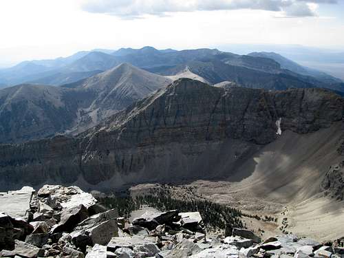
The summit of Wheeler is actually a fairly thin ridge. The highpoint is on the western side, towards US 93. Some yards away to the east is a lower summit cairn, and this is where you get your views of the spectacular Jeff Davis cirque. I felt a little uneasy with the vertigo above Wheeler’s north face, and didn’t dare step near the edge.
![I m scared of heights]() Me scared Me scared |
![View South]() South South |
![West into the heart of the Great Basin]() West West |
![Southwest]() SW SW |
![Jeff Davis Peak]() Jeff Davis Jeff Davis |
![North Schell from Wheeler]() North Schell Peak North Schell Peak |
![North from summit]() North towards Moriah North towards Moriah |
We descended, and the solo hiker, who had come up from the Wheeler Peak Campground, decided to take a shortcut back through the scree fields back to the park’s designated Bristlecone area, where he could link back up with the Campground. I had had enough of scree and talus for one trip, and decided to follow the trail back to my car. (Did I mention how remarkable this trail is? It is extremely well maintained all the way to the summit, never loose at all...I've already mentioned that).
![A hiker probes his way through the scree...]() Searching for a shortcut Searching for a shortcut |
![Last thousand or so feet to the summit]() Wheeler Wheeler |
About 1500 feet below the summit I crossed paths with several parties ascending the peak. The weather was turning at this point, so they probably got a little wet as they neared the summit. I felt a few drops of rain on the way down but nothing major.
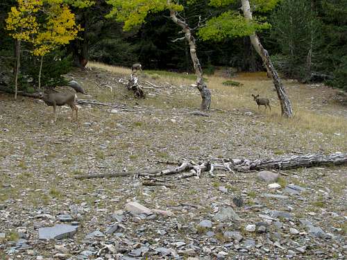
Before I reached my car, I was rewarded with the sight of a herd of about 7 deer grazing just a few feet off the trail. All in all, it was a pleasant hike, very easy, on a good quality trail, in which I probably made the best time of my life, speed and endurance wise, up a mountain. After all that had happened on this vacation, it was a good way to end it. Now for the long drive to Boston, and the long wait to next summer.
![Deer]() Deer on the trail Deer on the trail |
![Rain on the mountain]() Wheeler enshrouded Wheeler enshrouded |
Some interesting pictures of Lehman Caves from a few days before:
![Lehman Caves]() Lehman Caves
Lehman Caves![Lehman Caves]() Lehman Caves
Lehman Caves![Lehman Caves]() Lehman Caves
Lehman Caves


Comments
Post a Comment