
|
|
Mountain/Rock |
|---|---|
|
|
43.26177°N / 109.79951°W |
|
|
Sublette |
|
|
Hiking |
|
|
Summer |
|
|
11284 ft / 3439 m |
|
|
Overview
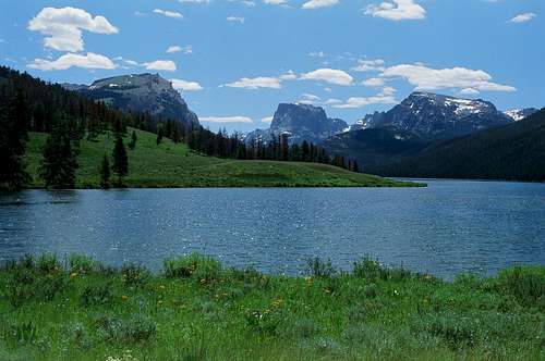 White Rock Mountain (left), Squaretop Mountain (center), and Big Sheep Mountain (right)
One of the most famous views in Wyoming is looking south-east from the Green River Lakes towards a dramatic mountain that is beautifully framed by the walls of the glacial valley leading up towards it. The summit appears perfectly flat, with near vertical cliffs rising up from the surrounding lowlands in spectacular symmetry. This mountain is not White Rock but is rather the more famous Squaretop Mountain and is not the focus of this page.
White Rock Mountain is the mountain that forms the left (or northern) slopes to frame this majestic view. It has ragged white and brownish cliffs on its southern flanks and more gentle northern slopes that are a mixture of conifer forest and alpine meadows. It is one of only a few peaks in the Wind Rivers that can be hiked up in a fairly casual day trip from the trailhead. As an added attraction, its surroundings comprise one of the most beautiful spots in the entire state of Wyoming.
The last couple hundred feet of the peak are a steep tower of mostly solid rock. There are magnificent views of both the Green River Lakes to the west, and the higher peaks of the range to the east.
Geology
The cliffs making up the southern side of the peak are sedimentary in nature, not granite as is found in the central peaks of the Wind Rivers. There are two steep bands within the southern cliff. The lower is made of Bighorn Dolomite and was deposited 425-450 million years ago. There is a less steep zone made of the Darby Formation, then the higher steep band is composed of Madison Limestone, formed some 300 million years ago.Getting There
From the Town of Pinedale, drive six miles west on US 191 or alternately, drive about the same distance east on US 191 from the town of Daniel. Turn north on Wy 352, and basically follow this road for 46 miles until it ends at the Green River Lakes Campground. The name of the road switches to Roaring Fork Rd. after 25 miles but you stay driving on the main road. The last 23 miles or so is an unpaved gravel surface but is fine for 2 wheel drive vehicles. View East from the summit of White Rock Mountain
If you are travelling south from the Jackson area along Rt. 191, a number of miles can be saved by taking the dirt Forty Rod Road left (east) a few miles after crossing over the Green River, and following it until it intersects Wy 352 where you turn back north to reach the trail head.
There is a clearly marked turnoff to the left just before the campground that leads to the trailhead parking. To access the peak, it is quickest to work down one of a couple trails leaving from the lot and cross over a good and new bridge to the east side of the Green River. From here, walk a couple miles south-east along the Highline Trail to just before the end of Lower Green River Lake where the Clear Creek Trail branches off to the left. Access to White Rock is easiest turning up this, passing by Clear Creek Falls, then taking the Slide Lake Trail to the northeast side of the peak. One can also admire White Rock's wonderful sedimentary cliffs by continuing up the Highline Trail past Upper Green River Lake rather than turning onto the Clear Creek Trail.
 Green River Lakes from White Rock Mountain
Red Tape and Other Concerns
White Rock Mountain is located in the Bridger Wilderness Area, so consequently, Motorized vehicles, mechanized equipment, and such things as snowmobiles, bicycles, hang gliders and chainsaws, are prohibited.Campfires are allowed below tree line, if you use downed timber for fuel.
Cell phone reception is poor to spotty here as is often the case with mountain areas.
I encountered the highest concentration of mosquitoes that I have ever experienced on the approach to White Rock Mountain in July. Many people go to the Wind River Range in August or early September for this reason. Bug dope would be a good thing to carry with you not only for the mosquitoes but also for noseeums and ticks...
This part of Wyoming is bear country, and there have been situations with grizzly bears here. It would be prudent to carry a can of bear spray (available in Pinedale) with you and know how to use it.
Sunscreen, sunglasses (and an ice axe in early season) are all also of great use when visiting the peak.
Camping
Within the Bridger Wilderness Area, it is possible to camp as long as you stay more than 200 feet from lakes and trails. Being bear country, you should use bear proof containers to store food when in the backcountry. Permits are required for scout or church, or school groups, as well as campers bringing livestock. Contact the Pinedale Ranger District (307-367-4326). White Rock Mountain from Lower Green River Lake. Photo is by PinedaleOnline.com and is used with their permission.
There used to be lodging in the vicinity of the Green River Lakes campground but this is no longer available. In addition, such popular spots as the Elk Ridge Lodge and the DC Bar Guest Ranch as well as the Place Restaurant have all recently closed. The closest lodging is in one of several hotels in Pinedale, or alternately a hotel in Daniel.
Weather
Click Here for Sublette County Weather!External Links

Information for the Green River Lakes Campground can be found here.
The Bridger Wilderness Area is discussed here, and the Wikipedia site for it is here.
The Pinedale Ranger District can be contacted at: 307-367-4326 or accessed using this link.
Alternately, the Bridger Teton National Forest can be contacted at (307) 739-5500 or accessed by clicking on the link.
Links to Pinedale hotels can be accessed here.
White Rock Mountain is within Sublette County. Their webpage can be accessed here.
Pinedale Online is a great resource for the area and can be contacted by clicking on the link or calling 307-360-7689.
Bob Sihler - Aug 23, 2013 8:21 pm - Hasn't voted
Northwest slopesI climbed this peak this morning by a different route. Instead of going on the Clear Creek Trail, I continued on Highline. Shortly after the bridged crossing of Clear Creek, I left the trail and aimed for a less-dense section of forest up to the ridges above. By linking numerous game trails, one can actually do almost the whole thing to the meadows above without much bushwhacking at all. It was a little shorter than the NE route as well, about 11 miles RT, and took me just less than 5 hours out and back. I'll work on a route page to complement this page sometime this fall but wanted to put it out there that there is a shorter way that is not much more difficult and maybe not more difficult at all.
RobSC - Aug 24, 2013 11:05 am - Hasn't voted
Re: Northwest slopesThanks for the comment. This looked like a good route to me as well, so it would be great if you could add a page for it! I used the route that I described as this was the way that I had gone in 1977 with my father. On that trip, we turned around a bit shy of the summit at the start of the scrambling, so I wanted to finish the route. Since 1977, the NE route has grown in some as trees have refilled some slide areas.