Prologue
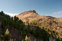
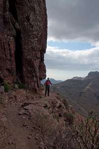
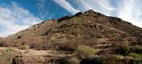
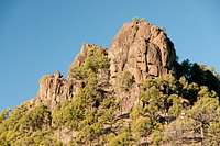
![Cumbre Central above Fataga]() Cumbre Central above Fataga Cumbre Central above Fataga |
It is December 23rd and we have just gone through the routine of exchanging Christmas presents. Tomorrow on Christmas Eve we’ll fly down to the Canaries and we simply decided not to lug everything to the islands and back. Suitcases are packed, we are already checked in via web and tomorrow before 6 we’ll have to get up and going. Now we both are filing through our guidebooks of
Gran Canaria, every now and then consulting our maps.
Gran Canaria – somehow I’m only lukewarm about spending two weeks there. We already visited the island eight years ago and there’s little I remember about it: bad weather in
San Matteo, where we had rented a finca, an island highpoint off limits due to a military radar installation and dry and dusty areas in the south. I don’t have any recollections of mountains on the island but our first hike had been fabulous – a big tour around the central range, the
Cumbre Central with impressive rock formations and huge basalt walls. I’m sure we both want to repeat this.
Still I’m lukewarm. I know Judith is happy – she liked it back in 2003 – and she can be sure weather will be warmer than the crap we have been having here in Germany for the last weeks. Maybe I should also concentrate on the escape aspect of the vacation. This last weeks have been tough on the little company I work for since we lost 6 employees. More than 10%. My whole team has left and I had plenty of chances to see the downsides of a management position. I want to get out. Why not
Gran Canaria?
Travelling
Driving the motorways on the Canaries is relaxing if you are used to the hectic German ones. But I always have to wonder why their surroundings always have to look so horrible. Granted: between the lanes there are blooming bushes but if you look to the left or right you always see construction, quarries, dumps. The settlements beside the motorway are rather industrial zones and, honestly, you wouldn’t even like to enter any of the supermarkets you see there. Everything has the word “discount” written right across it.
But actually I’m quite content with the day so far. Everything worked out perfectly. What a change to the last two years when storms over the Canaries and winter chaos back home delayed our arrival for more than six hours. Today the baggage drop took only three minutes and while the security check took long we reached the gate just in time to board the buses. We were the last to enter the first bus which made us the first ones to board the plane. The flight was smooth and though baggage retrieval was chaotic, getting and finding the rental was quick and now we are on our way.
Meanwhile we are in the south of the island near the
Maspalomas exits. I can’t say I like what I see. Big hotel buildings all over the place and it doesn’t even look like anybody cared for how the place looks. And this is where people spend the few days of vacation they have each year! How depressing! I’m glad that we rented a finca in
Fataga, a few kilometers to the north. It is called a mountain village and even at an elevation of around only 300m this sounds soothing.
We turn off at
San Fernando and head north- and upwards. To the left there is a huge construction quarry which we gradually leave behind as we get higher. A sign advertises a mirador (lookout) ahead at
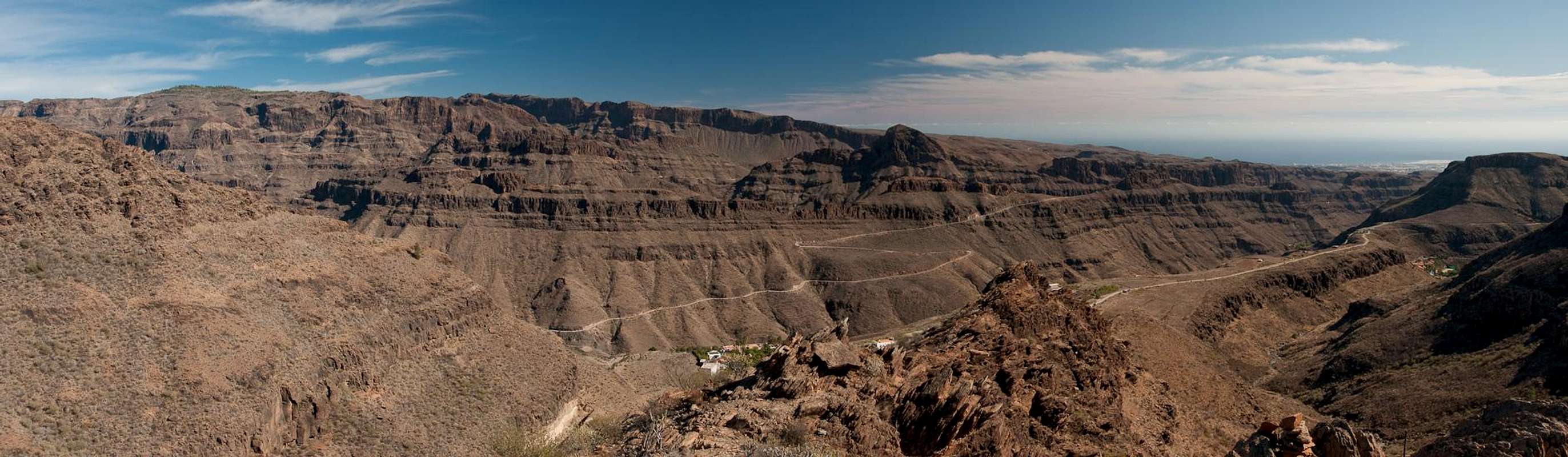
Degollada de las Yeguas. We get there – and all my doubts are suddenly swept away:
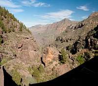
![Barranco de Fataga]() Barranco de Fataga
Barranco de Fataga
The picture doesn’t even get close to what you really experience in the place.
Barranco de Fataga is a Grand Canyon like though much shorter and lower canyon. The road hugs the walls to the right and the whole area to the left looks wild! This is where we’ll stay for the next two weeks and with big smiles on our faces we arrive at our finca. From the garden attached to it we can see the
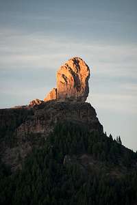
Cumbre Central with the three highest mountains:
El Campanario (1926m),
Pico de las Nieves (1951m) and
Roque Redondo (1921m). What more can you wish (see image at the very top of this report)? And yes – this is Christmas Eve :-)
Pilancones Natural Park and Montaña Negra
Tired of travelling we have decided to do a hike close to
Fataga and though we have got lost en route we still reach
Ayagaures before eight in the morning. At our parking lot near the dam of a reservoir we get greeted by two little dogs. Judith chases them away but after we have gotten ourselves ready for the hike one has returned. He has decided to adopt us and guide us to the sights of the area. Since this is the fourth time that such a thing happens to us I think Judith and I really must look helpless in the eyes of dogs. But this one – for a change – actually looks quite cute:
![Dog Adoptor]() The dog who adopted us
The dog who adopted us
The day is spent with a hike around
Montaña Negra. The mountain, though impressive when seen from below, vanishes as you get higher and higher. The area we hike through has been devastated by forest fires in 2007 but the sturdy Canary Pines already look like nothing has happened. Only the bark is still black.
Montaña Negra has some interesting cave-infested walls in its south face which make way to black basalt pillars as you get higher. The mountain itself can be reached from an unnamed saddle and it looks like rarely anybody ventures there. There are no tracks to be seen as we struggle to the top.
On the summit we take our lunch break and our little companion is so tired that he doesn’t even care to beg anything from us. On our way back to the saddle he trails behind but slowly recovers once we get back to places he remembers. We circle
Montaña Negra and get down into a different valley with abandoned villages. The path turns into a dirt road and as we get close to the
Ayagaures reservoirs our dog is less and less to be seen. Still he waits for us every now and then and guides us safely back to our car. Here he is greeted by a family of locals who just stepped out of the Christmas service in their church. We say goodbye and leave.
Riscos de Tirajana
![Roque Nublo, Teide, Altavista and Roque Bentaiga]() Roque Nublo, Teide, Altavista and Roque Bentaiga
Roque Nublo, Teide, Altavista and Roque Bentaiga
Starting at
Degollada de la Cruz Grande we are greeted by a wonderful sunrise above the clouds. Today we’ll hike to the island’s highpoint,
Pico de la Nieve, and the guidebooks tell us that this is one of the big tours on the island. In 2003 we hiked there from the other side of the island and had to step through layers and layers of dense fog. It turns out that the Camino Real (king’s highway), on which we are hiking, is a wonderful piece of centuries old construction. Above
Cruz Grande huge walls of several hundred metres height loom – part of the big climbing area of the island) – and the camino runs right through it. First on a ledge, later on ramps which were built between balconies among the walls. It tops out on the high plateau
Llanos de Pargana, from where it takes you through a pine forest to
Degollada de los Hornos.
After a first glimpse of
Roque Nublo we head to the next saddle,
Degollada de los Gatos. Here a path turns of and we head for Gran Canaria’s second highest summit,
El Campanario. Not difficult but the top is exposed as it hovers above the 400+m drop of
Riscos de Tirajana. A wonderful place. We scramble onto what we think is the top of the mountain and take a look around.
Pico de las Nieves to the east,
Roque Nublo to the north, and above it all hovers the silhouette of
Tenerife with Spain’s highest mountain,
Pico del Teide.
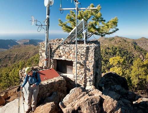
Down we go again and cross over to Pico de las Nieves. In addition to the radar installation there is a road right to the top with a van selling souvenirs. It has a wonderful view though but after enjoying it we head on. We have to use the road which takes us past
Roque Redondo with its radio and TV towers and our final destination for the day is a fire lookout right beyond. There we have a wonderful view of
Riscos de Tirajana and the way we came. After lunch we return and retrace our steps. Clouds pile up above the riscos and the sun gets shut out. Right before we reach our car we get passed by the first (and last) mountain bikers we see on Gran Canaria.
Merry Christmas! The Weather Divide
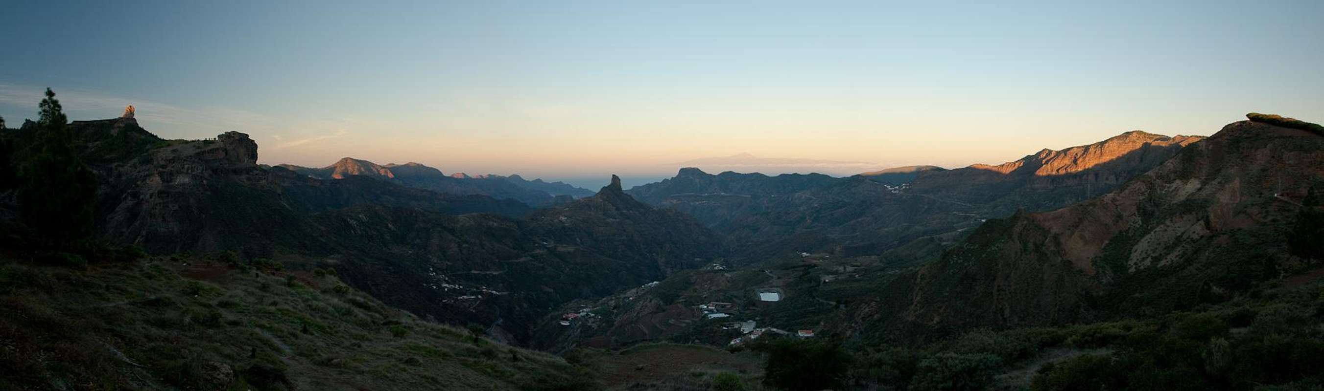
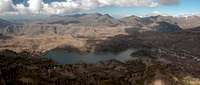
Early morning panorama of Caldera de Tejeda |
We are back to the
Cumbre Central. After a stopover at
Degollada Becerra where I took a few sunrise photos we start from
Cruz de Tejeda, the main road intersection on the cumbre. The goal is to head for the Canaries’ highest village,
Artenara, along the northern rim of
Caldera de Tejeda, Gran Canaria’s weather divide. When we start there’s not much of a weather, a few high flying clouds but a crispy wind below freezing temps. We meet a shepherd with his flock, which contains quite a number of newly hatched lambs – an enjoyable sight. After attaining our highpoint,
Los Moriscos, we decide to descend farther north for a visit of
Pinos de Galdar, one of the few remaining volcanic craters of the island. On the way we pass
Montañon Negron, where Gran Canaria’s last eruption took place 3000 years ago. At the mirador a busload of people enjoys the crater so that we immediately turn around after a couple of shots.
We avoid
Los Moriscos (will get there upon returning anyway) and head directly to
Cuevas del Caballero, caves which at some point in time composed a small village. Today they are abandoned but you wonder why on earth somebody would want to live there, right in the middle of nowhere. The views are exceptional as the caves have formed high in the walls of
Caldera de Tejeda which drop for several hundred metres into the crater.
After scrambling around and taking looks into some of the caves we head on but before we start the final descent to
Artenara we decide to rather head for the top of another mountain on the caldera rim to take our lunch there. From our vantage point we realize that again, like yesterday, clouds start rolling over
Cruz de Tejeda. We hurry back and have the good luck to hit the clouds only as we near the parking lot with our car.
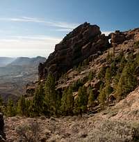
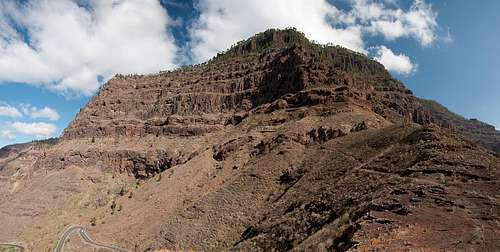
Cresta Pajonales
![Morro de Pajonales]() Morro de Pajonales
Morro de Pajonales
Today we start from the road pass
Degollada del Asserador – or rather close to it. Here the north and east faces of
Montaña del Asserador drop towards the road, a view I still had on my mind from 2003. Our path starts beneath the north face of
Los Canadores, a two summitted basalt foundation on the west side of the degollada, which also is one of the famous climbing locations of the island. We pass the rocks and quickly climb to our first highpoint,
Montaña de los Jarones. A second, unnamed summit is traversed and we find ourselves on the east slopes of
Morro de Pajonales. We pass it to the south and as we descend we realize that the morro also has wonderful basalt pillars, which drop for about 200m towards its north. I decide that upon returning I will have a closer look and attempt the summit.
We now head down towards
Embalse de la Cueva de las Ninas, the biggest reservoir on the island. Hiking is easy and we soon find ourselves on the bank of the big lake. We take our lunch break but then have to hike 3km on a road before another path takes us back to the east face of
Morro de Pajonales. Unfortunately there is quite some traffic.
Back at
Morro de Pajonales I realize that the summit can be easily reached from the south-east and after some bushwhacking we stand on top. Pines obstruct the views so that peak-bagging is the only reason to go there. We now retrace our steps to
Degollada del Asserador, from where I shoot one last picture of the
Montaña del Asseador rock faces.
Montaña del Viso, Montaña de Tauro
The Morning: Montaña del Viso
![Montaña del Horno]() Montaña del Horno seen from Degollada de la Aldea
Montaña del Horno seen from Degollada de la Aldea
Bad weather today with overcast skies with dark clouds. The only blue sky can be found in the south-west of Gran Canaria so we head there. The drive is horrible as we have to drive through several of the tourist “resorts” of the island, which make us both shudder. In
Degollada de la Aldea we park our car for a loop around
Montaña del Horno, where azulejos, brightly coloured volcanic rock can be found. The first part is a traverse underneath the mountain’s west face with an ascent to its north-west ridge. There on the ridge we realize that heavy weather is closing in and decide that after a short visit to the summit of
Montaña del Viso we’ll return and call it a day.
However, after the lunchbreak on the ledge all clouds get blown away and back at our car we ask ourselves what to do with the rest of the day.
The Afternoon: Montaña de Tauro
Driving back to the town of
Mogan we decide that we don’t want to head through tourist construction again but rather drive back up towards the
Cumbre Central. A narrow winding road takes us up out of
Barranco de Mogan and Judith, leafing through the guidebook, suggests
Montaña de Tauro, a 2h hike. We had been there in 2003 but the mountain itself didn’t register with us. What we remember, however, are the huge drop of the
Laderones de Mogan, the north-west faces of the mountain and seeing them again was among my plans anyway.
![Los Laderones]() Looking down into Barranco de Mogan from Montaña de Tauro
Looking down into Barranco de Mogan from Montaña de Tauro
There’s not much to say about the ascent since it runs on a marked path. Close to the top are the ruins of a farm building, where you have good views across the plateau towards the
Cumbre Central. Today, however, the range was still shrouded in clouds so that we could only admire the reservoirs on the plateau. After a visit to the flat summit we return to
Degollada de la Laja, where we take a break on an overhanging rock (as I later realize) above the drops of the
Laderones. The sun is already starting to set so we return.
Morro de la Hierba Huerto
Today we are back in
Parque Natural de Pilancones. Starting from
Cruz Grande we follow a ridge towards our final destination,
Morro de la Hierba Huerto. It is a long stretched mesa with a big drop at its north-eastern end. After consulting our map we decide to take a detour to the south instead of climbing it directly. At
Degollada del Sordo we turn southward and follow the east slopes of the morro. We trudge on and on and on and instead of finding a path to the top the walls get higher and higher while we lose more and more elevation. There are several sources right on the trail, a strange sight in this otherwise dry and barren landscape.
We turn another corner and still no sign of a trail in the right direction. I propose to hike to the next saddle and if nothing can be found there, return the way we came. In the saddle, which turns out to be
Degollada de los Helechos, there is an intersection but the left hand trail runs further to the south while the right hand trail appears to circle a valley and then head southwards as well. I propose to give it a try and Judith reluctantly agrees.
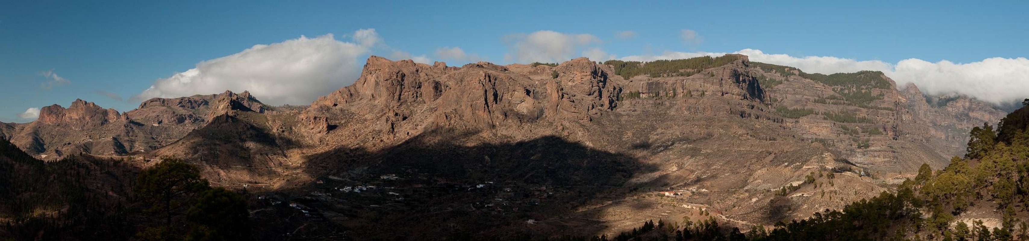
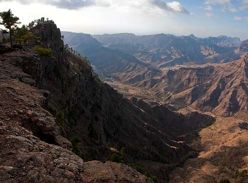
Gran Canaria's Cumbre Central seen from Morro de las Cruces |
After several hundred metres it turns out we are finally on the right track. The path leads through the barranco, steadily ascending in the right direction. The higher we get the more beautiful the valley becomes and we wonder why this tour is not described in the guidebook. Finally we top out on the mesa and Judith decides we should take our lunch on the next hilltop. There I consult my GPS which tells me that the summit is only 700m away. So I convince Judith to go to the top where we have a wonderful view of the
Cumbre Central. This view is only topped when upon returning we take another break on
Morro de las Cruces where an already setting sun paints the granite faces in shades of red.
Altavista
![Roque Nublo and Roque Bentaiga]() Roque Nublo and Roque Bentaiga casting their shadows into Caldera de Tejeda
Roque Nublo and Roque Bentaiga casting their shadows into Caldera de Tejeda is still asleep as we start the ridge traverse to
Altavista. We’ve been here before but the only thing we remember is horizontal rain into our left ears the whole way back. Today weather looks better but since here on the Canaries weather can switch within 15 minutes you can never be sure. The first part of the traverse runs through the pine forest and only occasionally can we glimpses into
Caldera de Tejeda.
Roque Nublo and
Roque Bentaiga throw shadows into the crater, which is still covered in mist.
The hike takes longer than I remember and with a lot of ups and downs we finally pass the real summit, heading for the lookout in the far west of the mountain. While Judith has her lunch I explore the mountain and quickly the uncomfortable feeling I had here in 2003 returns.
Altavista has vertical walls all around. From the summit steep slopes lead to these walls and these slopes are covered with the long needles of Canary Pines. A slippery affair!
Upon returning we climb the real summit, then step towards another lookout over the caldera. Finally Judith claims her iPhone indicates another loop trail and she suggests to follow it. The path is there all right so we descend towards the plateau of
Accusa. Before we reach it, however, we turn back onto a trail which traverses the
Altavista south slopes and heads back to our trailhead in
Artenara.
The Famous Roque Nublo Round Tour
![The Cloud Cascade]() The Cloud Cascade
The Cloud Cascade
Weather is perfect but as we get close to our trailhead at
Degollada Becerra we realize that a cloud cascade has already developed there. Stepping out of the car we also realize that in the saddle we have full force winds which blow away the warmth of the car within seconds. The sun has not yet risen and it is near freezing temperatures. We start the traverse in the direction of
Pico de las Nieves, first with good views of the Caldera, then through forests and across orchards. After about two hours we reach the saddle
La Goleta, the staging area for
Roque Nublo. There are no crowds yet but another couple is getting ready to hike the short hike to Gran Canaria’s landmark.
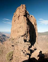
The area is beautiful, red basalt rock, blue skies, green pines, no clouds. We pass by
El Fraile, a rock which looks like a praying monk and finally head out on the
Roque Nublo plateau. There are already climbers on the rock and we take our time watching them and enjoying the vista. As more and more people get out onto the plateau we decide to leave, retracing our steps and then circling
Roque Nublo beneath its north face. On the far side we head out onto the plateau of
Montaña del Asserador with the Montaña on the right and
Riscos del Laurel to the left. As we head down the space in between both and get to a small reservoir,
Riscos de Laurel develop into a huge face above the road through
Degollada del Asserador. There are climbers somewhere – you hear their shouts equipment but the face is so huge I can’t discover anybody.
On another rock, right above the degollada we stop to take our lunch break. To the right a group of climbers are practicing slab climbs. Through the pass we can see
Teide on Tenerife. It turns out this is a good place to rest. But every lunchbreak has an end and we prepare for the worst part of the day. We’ll have to hike some 3km across the road, which during the early afternoon is quite well used. Occasionally I stop to take a picture but Judith rushes on and I have to hurry to keep up. Finally we get to
Cruz de Timagada, an intersection of Caminos Reales, from where we have a wonderful view of
Roque Bentaiga,
Altavista and
Tenerife’s Teide, all perfectly lined up.
![Teide, Altavista, Roque Bentaiga]() Teide, Altavista, Bentaiga
Teide, Altavista, Bentaiga
We follow the camino towards the village of
La Culata, where in 2003 we got lost and had to scramble back to
Degollada Becerra through fields of cacti. This time we find the right path and enjoy the hike along the walls of the
La Culata Cauldron with the rising moon above our heads. Finally we get to the last section and we have to realize that not only we are back – clouds and wind have returned as well. Some quick and tired steps and we are back at the car.
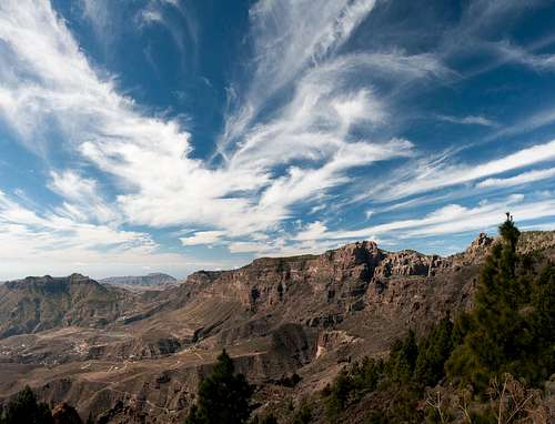
Watch the Skies!
![Cloud patterns above Riscos de Tirajana]() Cloud patterns above Riscos de Tirajana
Cloud patterns above Riscos de Tirajana
Today we have crossed the weather divide and you can feel it. As we are driving up
Barranco de Guayadeque dark low hanging clouds pass us. The barranco itself is quite impressive. It starts at sea level and cuts deep into the island ending close to its centre. Big walls close in on it and with the overcast skies trouble seems to loom.
Montaña de las Tierras ends the lower part of the canyon. The roads winds up to its side and then stops dead – our trailhead.
The hike through the upper barranco is a bit boring. With the walls to the side and the clouds above not much can be seen. And the weather remains unstable. Turning northward we head for
Caldera de los Marteles, another one of the fairly recent volcanic craters. As we get to the rim clouds sweep by hiding it from view. We discuss our further route and as we set out the fog lifts and offers another opportunity for a photo, which I immediately grab.
We pass the caldera to its south wondering about the description in the guidebook. We find none of the described landmarks but follow the pass we see instead and in the end we end up in the right place, right beside
Montaña de los Marteles and above the caldera. Here we cross a heath slope towards
Cuerva del Agua, a bend in the road which leads up to the
Cumbre Central. We are quite high now, 1750m, and I’m wondering whether we get close to
Pico de las Nieves. We should since the area above this elevation on Gran Canaria is quite small.
We cross another heath area and realize that we have left the clouds behind. We also realize that we are close to
Roque Redondo with its antennas and thus close to the spot we had our lunch break in on our second day on the island. We hike up the south slopes of
Caidero de Urian but decide not to head for its summit which is covered in pines. Instead we head over to the edge, where the
Riscos de Tirajana drop down in the valley. We enjoy our lunch with wonderful views. Weather is perfect and the clouds draw feather-like patterns onto the skies.
On the way back we often ask ourselves whether we have got lost. The guidebook appears to be somewhat ambiguous. But we are on the right track and finally start a wonderful traversing descent into
Barranco de Guayadeque. Again it’s late and the lights are getting low. We’re quite happy once we are back at our car.
North of Tamadaba
![A ship called Tenerife]() A ship called Tenerife
A ship called Tenerife
With 1444m
Tamadaba is the westernmost mountain on
Gran Canaria. It is home to several camping zones and a picnic area, where we start today. We have been here before, descending towards
San Pedro 1000m below, than heading back up through
Barranco de Agaete. And this is exactly what we want to repeat today. The first part of the descent is a bit lame but once we get out of the pine cover it starts to get impressive.
Tamadaba drops of with huge walls into
Barranco de Agaete and we are now negotiating a rib in between. It heads for
Roque Bermejo, one of the cultural places of the prehispanic inhabitants of the islands, the
Guanches.
We hike to the top of
Roque Bermejo, then follow the Camino Real along the cave infested south slopes of the mountain towards the village of
San Pedro. Here we have to follow one of its streets before heading into the creek bed of
Barranco de Agaete, heading southwards. Here we join a couple of ladies, also from Germany, with whom we stay for the next hour. We have lunch together before they return to
Agaete while we head onwards towards the end of the barranco.
Another Camino Real awaits us above the village of
El Sao and takes us towards
El Hornillo, a village of cave dwellings. A few steps on the road then we head down to the dam of
Presa de los Perez. We have to hike across the wall, while on the outside of the dam a dozen big dogs furiously bark at us trying to get up the wall. On the other side we start reascending to
Tamadaba which we reach late and very tired.
South of Bentaiga
![El Espinillo underneath Roque Bentaiga]() El Espinillo underneath Roque Bentaiga
El Espinillo underneath Roque Bentaiga: today we’ll start here though the guidebook wants us to start at
Roque Bentaiga. However, we did the tour in 2003 and the road hike between
Degollada de Asserador and
Cruz de Timagada was no fun in late afternoon. So we start with the road hike today and since it is not yet 8 a.m. only one car passes us. At
Cruz de Timagada everything is still in the shadows and only as we start to descend from the crest of
Las Morradas. Naturally we decide to hike up to
Bentaiga which takes half an hour but is worth the detour.
From here we descend into
Barranco de la Aldea de San Nicolas, passing the villages
El Espinillo,
La Solana and
El Chorillo. The white houses of the villages are a wonderful contrast against the blue sky. All the way,
Bentaiga looms above us one one side while
Altavista marks the other. Finally,
Roque Nublo also makes its mandatory appearance. Even though the barranco is obviously inhabited the skyline with all its rock makes it look very wild indeed.
At
Degollada del Manaotial we turn the corner and head for
El Carrizal, the next of the mountain villages. We hike up
Barranco de Siberio towards
El Toscon, where we see
Roque Palmes growing out of Barranco del Toscon. A short break on an overhanging rock with the little sanctuary, then the traverse of the upper barranco finally takes us to a saddle, from where 1.5km of road hike take us back to
Degollada del Asserador.
Montaña de Sandara
![Fire lookout on Montaña de Sandara]() Fire lookout on Montaña de Sandara
Fire lookout on Montaña de Sandara
Today we are back in
Pajonales Natural Park. Starting where we ended yesterday, in
El Juncal close to
Degollada del Asserador, we follow a dirt road to the saddle
Cruz de la Huesita. Here we turn onto the
Pajonales Ridge, heading for
Morro de la Negra. We pass it to its south, cross a saddle and stand in front of
Montaña de Solapos de la Carnicaria, which we pass to the north. Afterwards we do a big loop around Montaña de Sandara, which we climb from the western side.
After a brief break near the fire lookout on the summit we descend and head towards
Montaña de las Yescas. Instead of climbing to the summit we decide to scramble onto a basalt pulpit in its south which offers wonderful views from the
Cumbre Central to the mountains of
Gui-Gui in the south-west with
Montaña del Tauro and
Morro de la Hierba Huertos on the other side of the wide plateau at our feet. The vacation is almost over and we can see so many of the places we visited in the last two weeks. After lunch we return the way we came.
Los Palmitos to Montaña Alta
Today is the last day and finally we decided to hike the
Los Palmitos Loop. Our guidebook claims it is very difficult and exposed so that we saved the best for last. Starting at the parking lot of
Los Palmitos Park we suddenly find ourselves in the grounds of the attached hotel. There are "No Trespassing!" signs everywhere, yet the guidebook claims we have to pass through the grounds. After the forest fires the hotel has been abandoned and nobody turns us out but still we feel a little uncomfortable hiking here.
Looking across Barranco de Ayagaures |
Once across we enter upper
Barranco de los Palmitos, a low but narrow valley. After crossing the barranco bed the path quickly rises and finally heads out onto
Lomo de Chamoriscan. We pass a hill and suddenly stand above
Barranco de Chamoriscan, where the difficult section is supposed to begin. We follow the path, which traverses the slopes above the barranco but before we head into any difficulty the section is already behind us. Ahead the path is clearly visible on top of the lomo so we feel very disappointed about this “most difficult hike of Gran Canaria” .
Deciding to head for
Degollada de los Helechos, where we turned hiking to
Morro de la Hierba Huerto more than a week ago, we pass some very colorful basalt walls. Instead of hiking to the top of
Montaña Alta we follow the official path instead and quickly get to the degollada. We take in the views of the
Pilancones Natural Park and decide to have lunch. Upon returning we split with Judith retracing our steps and myself bagging the
Montaña Alta summit. The path is more difficult than anything before but the views from the summit are a disappointment since they don’t differ from anything we saw before. Meeting again on
Lomo de Chamoriscan we descend into
Barranco de los Palmitos and into the hotel grounds again. We find the gate has been closed so that we have to climb across it making us feel all the more like the trespassers we are.
Epilogue
In the taxi back home from Frankfurt airport I already long back for the weather of
Gran Canaria. It’s not particularly cold but a rainstorm is coming down at us. The plane ride has been very rocky and landing on the new runway was pure excitement. Monday I’ll have to deal with whatever happened at the company in the last two weeks – the mailbox on my mobile is already full.
But after all – those last two weeks pushed all that crap away. And finally I can admit I liked the island…
Comments
No comments posted yet.


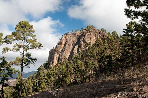


 Cumbre Central above Fataga