
|
|
Route |
|---|---|
|
|
52.76094°N / 3.72439°W |
|
|
Trad Climbing |
|
|
Spring, Summer, Fall |
|
|
Less than two hours |
|
|
HVD (USA 5.4-5.6) |
|
|
6 |
|
|
Overview
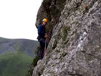
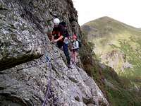
A quick glance over Craig Cywarch’s ukclimbing page will reveal that Will o’ the Wisp (HVD, 95m, 6 pitches) is by far the crag’s most popular line. If you don’t like excess company when climbing, don’t worry, popularity is a relative concept, and this crag will generally see no more than one pair of climbers on an average weekend, and there’s a fair chance that one of them will be me! The climb’s popularity is well justified, as it's not only one of the crag’s most accessible routes, but also the most enjoyable ‘easy’ climb the area has to offer. A rising traverse which follows a natural weakness in the rock; the climb is easy angled, has some nice holds and offers good protection. Its central pitches are also wonderfully exposed, with the green and wooded pastures of Cwm Cywarch tumbling and falling away below them before melting seamlessly into the rolling landscape beyond. If you only plan to do one route on Craig Cywarch, I strongly recommend you consider this one. FA: J.A. Sumner and J.P. Henrickson, April 4th 1972. |
Getting There
To reach the trailhead turn off the A470, which runs between Dolgellau (SH 729 181) in the west and Machynlleth (SH 748 008) in the south-east, at Dinas Mawddwy (SH 858 148) and take the road towards Aber-Cywarch (SH 867 157). Just after you cross the bridge at Aber-Cywarch turn left up an unclassified road signposted for Cwm Cywarch. Follow the road, which is narrow and winding, until you reach the parking area at Fawnog Fawr (SH 854 182). The approach begins here. |
Route Description
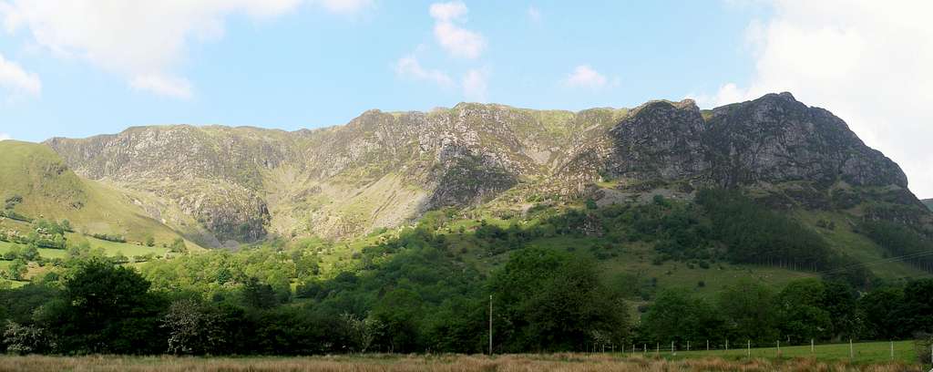
 The approach from the north (Photo by Nanuls) The approach from the north (Photo by Nanuls)ApproachThe climb is located on the aptly named Willow o’ Wisp Wall of Tap y Graig. Leave the car-park by following the road north until it terminates at Blaencywarch Farm (SH 852 159). From here continue north along the footpath which gradually turns to the left up the eastern slopes of Craig Cywarch. After around half a kilometre you should reach a small and indistinct junction in the path, stay alert it’s really easy to miss. Take this path which will then traverse in a south westerly direction across the base of Craig Cywarch towards the crags of Esgair Felen Isaf (SH 849 193). Before it reaches these crags the path deviates drastically, steeply climbing the hillside in short zig-zags to the base of Craig Cywarch. At the base of the crags you will reach a t-junction marked by a small stone shelter. Take the left hand path and follow the base of the crags in a southerly direction. The start of the route is located shortly after passing a large and obvious gully, and is parallel to the gap between the two forestry plantations below. If you find yourself passing a fence with a stile crossing it just below another obvious gully you will have gone too far. RouteThe route starts at a left-trending weakness on an easy angled crag. Pitch 1 (29m): Follow the initial weakness towards a small tree and a large block. After the block climb a leftward-slanting slab to a short wall and take this to a good stance to the right. Pitch 2 (8m): Climb an obvious crack above to a bulge, and then traverse up a ramp to an obvious ledge where a nut-slot belay can be taken. Just above you there should be a small square block of stone protruding from the cliff face. Pitch 3 (15m): Follow the ledge leftwards around a bulge in the rock-face, passing a small spike to gain a short ramp. Go up this with little difficulty and move delicately across a slab to an obvious crack. Climb the crack to the next ledge and set up a belay. Pitch 4 (17m): Walk along the ledge and step over a gap to a stance under a small overhang. Carry on traversing left along the gradually slanting rock-face which has some good holds. Finally climb up to a ledge close to the arête under an overhanging wall. Pitch 5 (8m): Clamber around the left hand side of the arête to a nice position on the arête and work your way up to an obvious tree and a large platform from where you can build a belay. Pitch 6 (18m): The final pitch takes a series of large square blocks. Climb up the blocks and head rightwards until a traverse left can be made to a small tree in a crack. Finish the climb by climbing up the crack.
DescentDescend via the large gully just to the left of the climb. Around halfway down you’ll reach a fork, take the left hand fork which leads to a stile which crosses a small fence. Cross the fence and turn left, the start of the route is just a few metres away. |


Essential Gear
A single 60m rope will be fine (or you may want to use a double) a moderate rack of nuts, hexes and maybe a few cams. Also be sure to carry a selection of slings and screwgates for constructing belays. The route is best done in rock shoes as boots would be way too cumbersome. Naturally you will also need all the other paraphernalia associated with climbing and hill walking in Wales: full waterproofs, fleece, hat, gloves and of course some lunch. |
Maps
Guidebooks
|

External Links
 Will o’ the Wisp (Photo by Nanuls) Will o’ the Wisp (Photo by Nanuls)Government Bodies and Official Organisations Snowdonia National Park Authority Association of National Park Authorities Royal Commission on Ancient & Historical Monuments in Wales Hiking, Climbing and Mountaineering Organisations and Companies British Mountaineering Council Plas y Brenin National Mountain Centre Weather Tourist Information North Wales Tourism Partnership Local Information from Gwynedd.com Local Information from Snowdonia Wales Net Travel Welsh Public Transport Information Accommodation Youth Hostel Association in Wales Maps and Guidebooks Cordee Travel and Adventure Sports Bookshop Wildlife and Conservation |