
-
 24199 Hits
-
 90.48% Score
-
 32 Votes
|
|
Mountain/Rock |
|---|---|
|
|
44.79140°N / 109.5927°W |
|
|
Park |
|
|
Hiking, Scrambling |
|
|
Summer, Fall |
|
|
10262 ft / 3128 m |
|
|
Overview

Windy Mountain is a beautiful peak in the heart of the North Absaroka Range in Wyoming; its large mass is visible from great distances, and it is the only peak in Sunlight Basin that is high enough to be visible from outside the Basin's rim. With an elevation of 10,262 feet, Windy Mountain has a prominence of 2,042 feet, and ranks 34th on the Wyoming prominence list. Reaching the summit is accomplished by a fairly easy Class I trail, and the summit views of the main crest of the range as well as the views north to the Beartooths are expansive and stunning. This is a rugged area, and be prepared to see signs of and possibly meet grizzlies, wolves, and a variety of other animals.
At one point in time there was a fire lookout on the summit, but only the four concrete foundation corners remain of the structure. An outhouse is perched on the edge of the cliff near the summit, which is a pretty unique sight in Wyoming! There is no summit register, but the wooden walls of the outhouse serve as a register of sorts with many names scratched or written in pen all over the inside of the building.
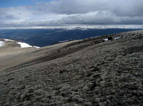
 The North Absarokas
Getting There and Climbing Information
 On the trail
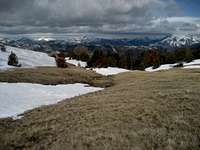 Meadow near the summit
Travel on Highway 120 for 17 miles north of Cody, Wyoming, and turn right on the Chief Joseph Scenic Byway, which heads west up and over Dead Indian Pass, reaching an elevation of 8071 feet. Right at the top, there is a turnout with information signs and restrooms; the views from this overlook are nothing short of amazing. After this, the road descends seven switchbacks down into Sunlight Basin; turn left on the Sunlight Basin Road and drive for 6.0 miles before turning right at the sign for the Wyoming Game and Fish Habitat, directing you to Trail Creek, Painter Gulch, Marguerite Draw, and Windy Mountain. Drive across the bridge and keep left at the first fork, following the signs to Painter Gulch. After this, there is a right fork and finally, 2.8 miles from the main road, turn left and head into the valley below the mountain. Follow the road through Painters Gulch for as long as your car can handle it or until you reach a small widening in the road at the top of a steep hill, after which the two-track road continues up a steeper hill where it narrows into a trail. The end of the road is 2.8 miles from the last left turn into the gulch.
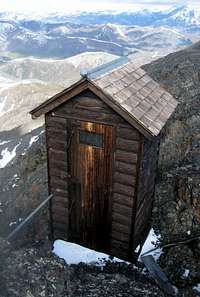 The outhouse
 Summit marker
Hike this trail around to the west side of the peak, where it starts to switchback as it climbs a ridge leading to the broad meadows north of the summit. From here, head south to the top, where there is a benchmark in addition to the outhouse and concrete posts. This mountain is climbable in early season, as this route is located on the part of the mountain that gets a lot of sun; at the end of May 2010, the trail above 9,700 feet had quite a bit of snow, but it was easy to avoid by staying high on the ridge. This would be a nice snowshoeing route in the winter, but unfortunately, the approach crosses a wildlife habitat area and is closed to human travel. However, it might be possible to skirt the closed land by starting in the neighborhood of Peak 7658, but you would have to cross the high ridge between that mountain and Windy. The northern approach described below would be an option for a lengthier winter ascent.
An ascent of Windy Mountain from the end of the road is a one-way trip of about 2.5 miles with 2100 feet of elevation gain.
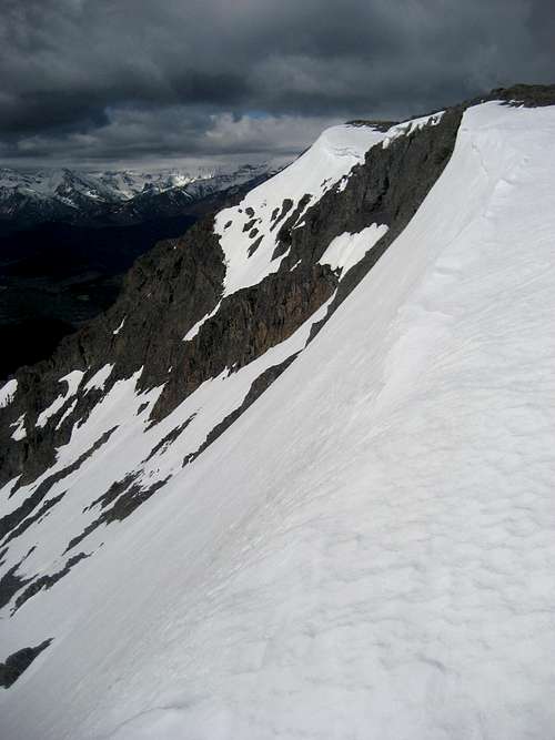 Just below the summit
Other Route Options
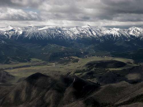 Summit view south
I have not explored these routes, but I have talked to one person who has done the northern approach; he was turned back before the summit by a lightning storm. The trail on the northern side of Windy Mountain makes for a longer hike, but it is probably the best option if you are interested in doing a winter ascent. Just north of Sugarloaf Mountain, turn west on Forest Road 114, and turn right on 115 when it forks. At whatever point the road ends, hike the trail along Reef Creek to a fork where you go right and ascend to a ridge which eventually connects to the other trail on the west ridge of the peak. According to the topo map, it is also possible to reach the Reef Creek Trail by hiking a trail that leaves the highway southwest of the Reef Creek Campground, though this would add even more distance.
From the end of Road 115, a one-way ascent would be approximately 4.5 miles with 2200 feet of elevation gain; add another 2.5 miles and 1400 feet if you start at the Reef Creek Campground.
If you find trails boring, a steep Class 2 or 3 scree scramble could be done just about anywhere on the south side of Windy Mountain; in fact, this would probably be the most direct way to the top, but it wouldn't save any time due to the extra difficulty.
Red Tape and Camping
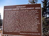 Habitat sign
 Grizzly track on Windy Mountain
Windy Mountain is in the heart of one of the wildest mountain ranges anywhere in the continental U.S.; grizzly bears, black bears, mountain lions, and wolves are incredibly thick in this area, and I have never hiked the area without seeing grizzly or wolf tracks, and I've even heard wolves howling in the valley below a nearby summit. Bring a hiking partner, take bear spray, and know how to use it! SP member TimW climbed Windy Mountain the day before I did, and he found a deserted bear den high on the mountain, and I saw quite a few grizzly tracks in the mud on the trail.
As noted before, southern access to the mountain through the Sunlight Basin Wildlife Habitat is closed to human presence during the winter, the specific dates being between December 16th and April 30th; other than that, all rules and camping regulations for the Shoshone National Forest apply to the area. For more information on the wildlife habitat, look at the larger picture on the right.
External Links
Chief Joseph Scenic BywayInformation on the North Absaroka Wilderness:
Wilderness.net
GORP site
Wikipedia
 Summit view to the Beartooths