
-
 26179 Hits
-
 76.66% Score
-
 7 Votes
|
|
Route |
|---|---|
|
|
34.09060°N / 117.0106°W |
|
|
Hiking |
|
|
Spring, Summer, Fall, Winter |
|
|
Most of a day |
|
|
Overview: Ridge of Splendor
The Yucaipa Ridge is a magificent piece of wilderness terrain that sees relatively few visitors – a plus for most hikers. Located in the San Bernardino National Forest, it parallels Mill Creek Canyon to the north with views toward the San Bernardino Crest beyond Mill Creek. Private property issues are probably one reason for the dearth of visitors since certain access points pass through private property.Pronounced "You-kigh-pa", the name derives from a word used by one of the indigenous tribes who inhabited the San Bernardino Mountains.
The peaks to be traversed on the Yucaipa Ridge range from 5,795 foot Allen Peak on the ridge’s west end, to 9,133 foot Little San Gorgonio Peak on its east end. Galena Peak (9,324‘), to the north of Little San Gorgonio Peak, is the high point of the Yucaipa Ridge.
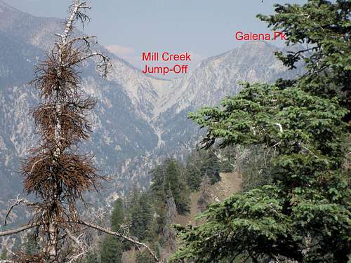
Galena Peak--highest point on Yucaipa Ridge
This route page for Little San Gorgonio Peak gets you on the ridge and from there you can head west and reach, in order: Wilshire Mountain (8,832’), Wilshire Peak (8,680’), Oak Glen Peak (8,404’), Cedar Mountain (8,324’), Birch Mountain (7,826’), and Allen Peak (5,795’).
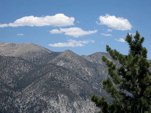
Part of San Bernardino Crest seen from Yucaipa Ridge
Getting There
Coming from the west, take Interstate 10 to the University Street exit in Redlands. Turn left onto University and proceed through the campus of the University of Redlands to Lugonia Ave./Hwy 38. Turn right at Lugonia and proceed about 14 miles through Mentone and up into the mountains to Forest Falls Road. Turn right onto Forest Falls Road and take it about 4.5 miles, passing through the Town of Forest Falls, to its terminus where you will find, on the left, trailhead parking for the Vivian Creek Trail.Route Description
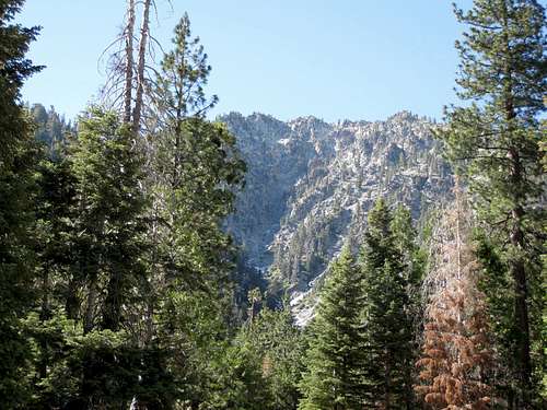
Route is on the left side of northern face of ridge seen here from near Mill Creek
From the Vivian Creek trailhead (6,080’) head up the road along Mill Creek passing the signed turn-off pointing left across Mill Creek to the Vivian Creek Trail. When you reach Camp Creek intersecting your route from the south, go past it until you reach the next major gully. Begin your ascent up this gully (going south), taking the left branch where the gully forks. At about 8,100 feet elevation, go left onto a southwest trending ridge that is intermittently ducked. Hike up this ridge to a small saddle at 8,440’. Continuing, at about 8,480 feet, the route turns more directly south and leads to the saddle just east of Little San Gorgonio Peak (elev. 9,133’). Turn right and continue up the ridge to the summit.

Wilshire Mountain

Little San Gorgonio Peak

Oak Glen Peak

Wilshire Peak

Birch Mountain

Cedar Mountain

Allen Peak

Dobbs Peak seen from Yucaipa Ridge
The hike and traverse, starting at the Vivian Creek trailhead, and going all the way to Allen Peak, is about 14.5 miles one way. Unless you want to do a 28-mile round trip, your alternative is to arrange a car shuttle so that you can hike out along the Ridge Truck Trail, through the Bear Paw preserve (having gotten the requisite permission of course), and back to your car. The other vehicle can be parked at the junction of Highway 38 and Forest Falls Road. If you use the car shuttle option, as opposed to a round-trip traverse on the Yucaipa Ridge, your total mileage will be about 18 miles with about 5,500 feet of gain.
Red Tape
If you do the route with the car shuttle, you will need to pass through the privately owned “Bear Paws” preserve at the end of the route. Accordingly, you will need to contact the caretaker of that facility to get advance permission to pass through the preserve. The following link explains how you get permission to access the Yucaipa Ridge from the Wildlands Conservancy: http://angeles.sierraclub.org/hps/guides/yucaipa.htmThe other piece of red tape is the requirement for an Adventure Pass or Golden Eagle Pass to park at the Vivian Creek trailhead. These passes cost $5 per day or $30 for an annual pass and can be purchased at many Forest Service locations and most major sporting good outlets.
Essential Gear
No special gear required in summer or any other time when the terrain is snow and ice free. Otherwise, snowshoes, crampons and ice axe may be necessary, as appropriate, during the winter season.
Galena Peak ridge in winter

Route from Vivian Creek trailhead in winter
Other Information
USGS Topo : Forest Falls 7.5 QuadExternal Links
Adventure Pass informationCalifornia Dept. of Transportation
San Bernardino National Forest
KathyW - Sep 30, 2013 9:18 pm - Hasn't voted
Yucaipa Ridge AccessHere's how you get permission to access the Yucaipa Ridge from the Wildlands Conservancy: http://angeles.sierraclub.org/hps/guides/yucaipa.htm They have parking and restrooms at their Bear Paw Preserve, and just want you to contact them in advance when you want access. Galena, Wilshire, and Birch Peaks are all within the Wildland Conservancy's land holdings. More on the Preserve: http://www.wildlandsconservancy.org/preserve_bearpaw.html
Augie Medina - Oct 11, 2013 2:23 pm - Hasn't voted
Re: Yucaipa Ridge AccessThank you for that information Kathy.
diersen - Nov 26, 2017 1:08 pm - Hasn't voted
Between Galena and Little San GorgonioIf you're planning to traverse this section, it makes more sense to go from Little San G to Galena. Most people seem to go the other way, which makes no sense. Going up Camp Creek to the ridge is a delight. Coming down it would be a nightmare. The ridge includes two sections within a half mile of Galena where there are short bits of mandatory loose, steep third class. Eastward, these are climbs, westward, they'd be scary descents that would be hard to identify as "the way to go" from above. Lastly, the Mill Creek Jumpoff is a lot more fun to go down than up. Do it west to east. You'll be glad you did.
diersen - Nov 26, 2017 1:17 pm - Hasn't voted
Can this be moved?Yucaipa Ridge shouldn't be a child of Little San Gorgonio Peak. The ridge should be the peak's parent. How to rectify this?
Augie Medina - Dec 15, 2017 5:56 pm - Hasn't voted
Re: Can this be moved?As you can see, I did it this way because the route I describe starts with Little San G. I don't know whether a Route can be a parent. I see your point but I don't know if the SP page protocol will accommodate your suggestion.