
-
 8030 Hits
-
 84.27% Score
-
 18 Votes
|
|
Route |
|---|---|
|
|
59.26048°N / 8.39863°E |
|
|
Trad Climbing, Sport Climbing |
|
|
Summer |
|
|
Most of a day |
|
|
5.7 (YDS) |
|
|
V- Norwegian, V UIAA |
|
|
9 |
|
|
Overview
Geographical classification: The Scandes > Hægefjell > Agent Orange
Agent Orange (Hægefjell)
The well known Telemark region in Southern Norway is home of a good number of fine granite dômes, located in the Nissedal and Fyresdal municipalities, near Norway's sixth largest lake, the Nisservatn. These dômes offer several great climbing on multipitches routes running on perfect granite resembing the Toulomne Meadows, near Yosemite.
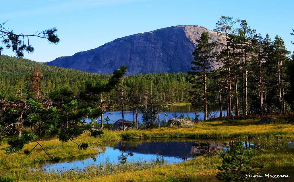
The two most popular venues are Hægefjell and Baremlandsfjellet, both in the Nissedal area, and in particular the rocky jewel of Hægefjell is quite the highlight. It shows high, vaste and slabby walls South, South-East and East oriented, cut by several cracks and divided into various climbing sectors.


The impressive South face is home of the hardest climb, while the more gentle SE and E slabs, located on the right if seen from the parking lot, show some accessible and less demanding routes. Among these there's a couple of magnificent climbing, Lara and Agent Orange, the route that is the object of this page.
Getting There
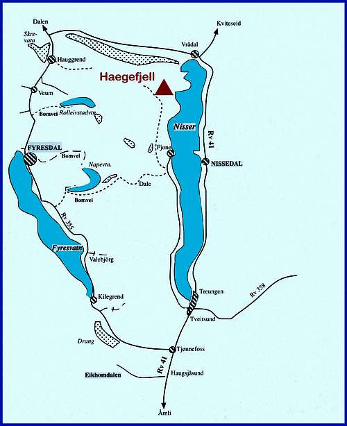
Hægefjell is located on the western shore of the Nisservatn, meaning Elf Lake, at its Northwestern edge, There is no direct road-access toHægefjell from the North, so you must approach it from the South. On the Southern end of the lake it's situated the small town of Treungen. This is the landmark to approach Hægefjell, a mandatory passage whether you come from the South or from the North, unless you want to take the small ferry connecting the two shores of the lake.

Coming from the North you will drive on the highway 41 which skirts the Eastern shore of Nisservatn and gives access to the village of Treungen. From Treungen drive in the direction of the Western shore of the lake. Once on the western shore follow the road running along the lake, passing some groups of houses and the small village of Fjone. The road continues to skirt the lake, reaching the Y junction. Take the left branch. Soon the road rises as it follows a stream past several beautiful farms, and quickly changes to dirt.


Follow this road for about 13 kilometers, pay the toll at the honesty box (70 NOK) and continue with the beautiful dôme already well visible, just in front, until the road ends at a parking lot. Hægefjell is just there!
Route Description
Agent Orange report - Norwegian scale
Summit altitude: 1021 m
Difficulty: V- Norwegian scale, V UIAA
Climbing length: 400 m
Equipment: various bolts along the pitches, equipped belays. Pitches only with bolts: 1,2,7,8 - Mixed pitches: 3,4 - Pitches with natural protection: 5,6
Exposure: SE
First ascent: Jan Petter Brenfelt, September 2000


A superb climb on excellent granite, pleasant and fun, with fixed equipment to be integrated. Setting of great beauty. Agent Orange is located in the right sector of the wall, 50 meters to the left of Sternsuppen and to the right of Tyrion.


Approach -The dôme is just in front and close to the parking lot. From the parking lot cross the concrete bridge and take a well-worn path, follow the right branch leading to the Hægefjell right sectors. The path reachs a greenish slab crossed by a black stripe. The start of the route is here (name "Agent Orange" partially cleared on the wall). 15 min. from the parking lot.
Route report
L1 - Climb the slab along the black strip, 4, 55 m
L2 - Easy slab at the beginning, then smooth at the end of the pitch, 4+, 50 m
L3 - Some little walls lead to the beautiful dihedral-crack slanting left. Climb it off-width, exit to the left to a belay between two blades, 5-, 60 m


L4 - Just above the stance climb up the wall, heading to a small overhang originating a crack. Climb the crack, then a slab and thin cracks to a stance below a smooth slab, 3+, 35 m
L5 - Climb the slab, skirt an outcrop and take a crack. Climb the crack and continue along a succession of dihedrals and thin cracks. With a short left traverse reach the comfortable stance, 3+, 55 m
L6 - Reach another crack, climb it, pass a small pine and continue on thin cracks to the belay, 3+, 55 m
L7 - Small walls and thin cracks, then easy spur. Follow the spur towards left to a stance in the midst of greenish slabs, 4, 60 m
L8 - Climb the greenish slabs and after a final steep but short wall reach a rocky basin in the midst of the slabs, 4, 60 m

From here it is possible abseiling down the route or, absolutely recommended, to reach the beautiful summit of the dome scrambling up easy slabs, A last slope lead to the summit. Big cairn and summit book.


Descent - The starting point of the descent route is a bit tricky to find, but once you begins to walk on an easy ridge heading North the track flows into a marked path inside the wood, then joining a dirt road, running below the South wall and getting the parking lot after about 1 hour from the top.


Essential Gear
Ropes 2x60, harness, helmet, 10 quickdraws, friends 0,5-3,5, nuts 2-7
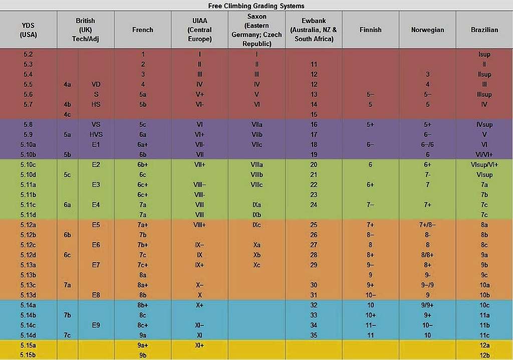
Main international rock climbing scales
See below a helpful conversion diagram:
Red Tape
No particulary restrictions. A toll to be payed in the onesty-box at the start of the road is due.
Where to stay
The closest accomodation is: Nisser Hyttegrend and Camping. Alternatively there are organized campsites all around the lake, in Treungen and on the eastern shore, besides cabins and room to rent all around the lake.
When to Climb
The best season goes from the end of May to the end of August
Meteo
Nissedal/Treungen meteo forecast
Guidebooks and maps

"Gå Telemark" - Klettern in Sudnorwegen by Gotz Wiechmann (in Norwegian and German)
Click here to obtain the topo of this route and various others on Hægefjell: Klatreforer Nissedal (in Norwegian)
There is also a Rockfax mini-guide: Nissedal (in English)

"Haegefjell" Rock Climbing and Bouldering Guidebook
This guidebook describes over 180 boulder problems and 16 long multi-pitch routes