
-
 6730 Hits
-
 86.85% Score
-
 23 Votes
|
|
Mountain/Rock |
|---|---|
|
|
36.58790°N / 118.11114°W |
|
|
Inyo |
|
|
Sport Climbing |
|
|
Spring, Summer, Fall, Winter |
|
|
4540 ft / 1384 m |
|
|
Overview

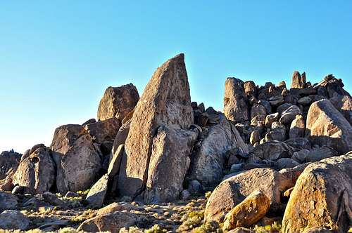
Arizona Dome is a rock formations in the The Alabama Hills on the outskirts of Lone Pine Peak in the Sierra Nevada Range, California.
This beautiful formation could have easily been named Arizona Spearhead. It has a sharp triangular shape with a narrow tip. Although this formation is very close to some very popular and sought after formations such as Alabama Dome, it doesn't seem to get nearly as much attention and foot traffic as it deserves. One of the reasons could be because you cannot belay from the bumper of your car, or that you have to climb over a rancher's fence past a locked gate to get to it. In any event, Arizona Dome is one formation that offers a degree of seclusion that many climbers look for.
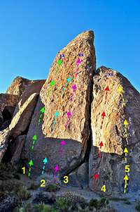
On my first visit in 2004, Arizona Dome had two bolted routes on the extreme right and left sides with a possible runout lead or top rope problem in between the two sport routes. On my last visit to Arizona Dome in 2010, I noticed two more new bolted routes appearing on the satellite formation to the north. The one on the left is a 5.7 face climb and a few feet to the right of that is another short bolted route climbing the arete to reach the same anchor bolts as the previous route.
Routes Topo
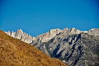 Mount Whitney jutting out from behind the hill.
 |
|
Getting there
 Locked gate. Please do not park near the gate. This dirt road and the gate are for the local ranchers only. Thank you.
From the town of Lone Pine on HWY 395, California, drive about three miles on Whitney Portal Road to intersect Horseshoe Meadow Road. Turn left onto Horseshoe Meadow Road and drive about one half a mile to a group of rock formations on the left side of the road. Park in the wide turn outs on either side of the road. Please do not park in the nearby dirt road with a gate. That road is for the use by the ranchers of the area.
Follow the dirt road to a green painted locked gate. There is a cattle fence. To the left of the gate you will see some small boulders that facilitate getting over the fence. From here walk about seven minutes till you see the dome to your right, west. A short cross country walk will bring you to a beautiful level base.
Camping
 Lone Pine Peak
If you don't mind driving another fifty miles, there are many campgrounds along Bishop Creek just to the west of Bishop. There are also many places in The Buttermilks area that are close to a creek that are suitable for camping. Please do not camp in The Buttermilks bouldering area. That area is very crowded and is suffering from the impact unregulated camping has caused.
The following links should help finding a good campsite
Horton Creek Campground
Rock Creek Canyon
Inyo National Forest
Bishop Creek and vicinity camping