Common Sense
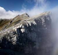
![The Ridge between Piz Lad and Äusserer Nockenkopf]() The ridge between Piz Lad (right) and Äußerer Nockenkopf from Reschen The ridge between Piz Lad (right) and Äußerer Nockenkopf from Reschen |
Common Sense dictates that you take a slow approach during your first outing after having spent half a year behind the computer screen. However, with me common sense is a poor dictator, which can be observed every year in September as we (girlfriend Judith and I) try to recover from our first vacation day after having returned from one of our epic first day enterprises. In 2005 we did the circle hike around
Monte Mulaz in the
Pale di San Martino, climbed the mountain in whiteout fog and then got washed down by torrents of rain. In 2006 a day of perfect weather induced us to climb the
Jaufenkamm Ridge in the southern
Stubai Alps, on which memorable day we stood on
Saxner,
Fleckner,
Glaitner Hochjoch / Monte Fumaiolo,
Kleine Kreuzspitze / Piccola Punta di Monte Croce and
Hohe Kreuzspitze / Monte Altacroce. Since we returned the way we came we stood on four of these mountains twice. Last year – judging that finally we should take the slow approach – we decided on
Golica / Kahlkogel in the central
Karawanken Range. This seemed not enough, so we climbed
Klek / Hahnkogel as well and got completely lost during descent. We ended up with 1500m of elevation gain and some 23km distance.
However, there are more serious dictators than common sense, weather being one of the most serious ones. In September 2008 a Sunday of on-and-off rain forced us to stay in the valley –
Upper Vinschgau or
Val Venosta Alta. We managed 15km and 800m of altitude and got drenched several times. So the epic was spared for the second day – or was it? Upon our arrival we had lunched at the shore of
Reschensee / Lago di Resia and while doing so had observed a long but easy looking ridge on the opposite side of it: it connects
Piz Lad in the north with
Äußerer Nockenkopf / Dosso di Fuori in the south and has two more summits in between:
Piz Nair and
Jochgrubenkopf / Piz Russenna. And that’s where we decided to spend day two this year.
Clouds
![Reschensee]() Reschensee and the south-western Ötztal Alps seen from Piz Lad
Reschensee and the south-western Ötztal Alps seen from Piz Lad
The unusual jumble of names might already prepare you that the climb took place in a border region, a region where three countries – though not languages – meet. Right to the north of
Piz Lad the Italian border with Switzerland turns into the Italian border with Austria, then cuts across
Reschenpass / Passo di Resia to obtain the Alpine main ridge in the
Ötztal Alps. Additionally in this area several mountain groups meet as well: our ridge belongs to the westernmost
Sesvenna Group, the huge group of the
Ötztal Alps is beckoning across
Reschensee / Lago di Resia and across the
Inn River there are the
Silvretta,
Samnaun and (further north)
Ferwall Groups. Perfect lookout conditions – or so we judged.
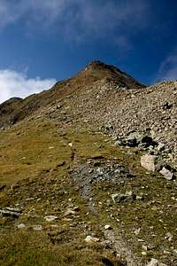
While
Piz Lad is a quite popular hiking destination – 2 ½ h will take you to its top from the nearest trailhead – the traverse is of far lesser importance. Most climbers follow Piz Lad’s long stretched ridge to the
Grubenjoch / Giogo delle Fosse Saddle, which separates it from
Piz Nair, and then return to base at
Reschner Alm, to fortify themselves with beer or apfelstrudel. We had decided on the traverse though only one of our maps indicated a marked trail up there. It was our oldest map, so we prepared ourselves for tricky route-finding situations. Moreover, all summits are in the 2700m – 2800m range. For flatlanders like us this might prove pretty challenging.
![Ortler / Ortles shining in the early morning light]() Alt-Graun's sunken church steeple in front of Königspitze and Ortler (a week later)
Alt-Graun's sunken church steeple in front of Königspitze and Ortler (a week later), where we stayed is about 30 car-minutes away from
Reschner Alm so when we saw a blue sky out of our living window we knew the plan would be executed. After a quick breakfast we hastily packed our things, rushed to the car and quickly headed out to
Reschen / Resia. There was no time to take the trademark picture postcard shot of the sunken church steeple of Alt-Graun, nor was the weather up to par. That part followed 9 days later when we were heading out to
Elferspitz / Cima Undici and
Zehnerkopf / Cima Dieci, two summits on the neighbouring ridge. The bumpy last part of the road slowed us down considerably but we reached the trailhead way before 8 a.m. and thus were the first ones en route to
Piz Lad. Unfortunately thick clouds hovered around the summit but it should be only a matter of time until they disappeared. Or shouldn’t it?
Summit the First
![Piz Lad]() Piz Lad seen from the military road
Piz Lad seen from the military road
Climbing
Piz Lad is certainly not the most adventurous undertaking. You follow a dirt road through a couple of gates, then turn left on a narrow but well-trodden path which takes you up the mountain in neat switchbacks. Halfway up this path runs into an old military road – witness of the times when European borders weren’t as open as today. During WW II, though allied, Austrians (then annexed into greater Germany) and Italians kept a weary eye on each other and the neutral Swiss, naturally, were weariest of them all.
The military road – “road” might be too big a word for this mule path – winds its way up the steep south face of
Piz Lad and as we followed it we had to realize that the clouds we had observed from below where still in place. However, they contented themselves with hovering above and below the north and west faces basically leaving the eastern views towards the
Ötztal Alps open. Underneath us – all around
Reschensee / Lago di Resia – they were dissolving but here they kept sweeping across the ridge.
![Summit Cross]() Summit Cross Summit Cross | ![Piz Lad Summit]() Real Summit Real Summit | ![On Piz Lad s south ridge]() Sesvenna Group in Clouds Sesvenna Group in Clouds |
I was taking photographs and Judith – who had got hungry during the 2 hours of ascent – started taking a “snack” (don’t ask). We were enjoying the ever changing aspects as the clouds kept moving around us. After a while they settled down a bit and remained underneath and we started to contemplate our further route.
The Main Event
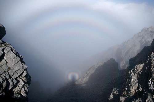
As we set out to leave the summit cross we observed that its and our shadows were perfectly visible in a saddle to the north-west. Judith noted a circular rainbow around her shadow and I started to joke about her aura which distorted the time-and-space continuum. A further glimpse and I could see not only the tiny rainbow around my shadow but multiple layers further out. It seemed like my aura was bigger than hers. Finally – the proof!
![Self Portrait]() The Brocken Spectre on the Loose
The Brocken Spectre on the Loose
We moved along the ridge to
Piz Lad’s real summit, which is located about 100m to the west of the summit cross (placed so that it can be seen from the villages around
Reschensee / Lago di Resia). We moved in the sun but right underneath us the clouds roamed. We descended into a col and there it was – shining brightly in the clouds my shadow was surrounded by two – three – four – five layers of light! Spooky!
A Foggy Traverse
![Piz Lad South Ridge]() On the South Ridge
On the South Ridge
Instead of staying on the trail we followed the ridge directly. Though on a clear day this would have resulted in breathtaking views down the north face, today only the shallow southern slopes remained open. Out there in the west only the highest summits of the
Sesvenna Group stuck their heads out of the cloud cover but the changing aspects kept up our interest.
In the end – at
Piz Lad’s western end that is – we started to descend to the
Grubenjoch / Giogo delle Fosse Saddle, a deep cut between
Piz Lad and neighbouring
Piz Nair. Here the regular hiking trail turned off east in direction of our trailhead at
Reschner Alm but we decided to follow the original plan and stay on the ridge. There were no marks but – something we had completely forgotten – the border between Italy and Switzerland runs along the ridge and thus every now and then a pillar would announce which country was on which side. Also, a path, barely visible in some places, well trodden in others seemed to prove that the customs officers of both nations must patrol there regularly.
Grubenjoch Saddle with Piz Nair (left) and Piz Lad (right) |
We descended into the saddle staying on the Italian side and avoiding the steepest part. There we caught our first glimpses towards
Unterengadin, the Valley of the
Inn River, a deep cut between the
Sesvenna and
Samnoun Groups, some 1800m beneath us! However, clouds still obstructed the views to the mountains opposite us.
Summit the Second
The climb out of
Grubenjoch / Giogo delle Fosse was very steep. We jogged along the east slopes of
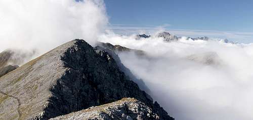
Piz Nair, with 2743m the lowest of the four summits on the ridge. During our ascent we observed a fore summit and a rocky main summit set apart and reachable across a long ridge. For once we decided to leave it alone and follow the main path which by now had become pretty faint. It levelled out onto a large plain where it vanished altogether. In the background, swept by the eternal clouds, the two remaining summits beckoned.
Jochgrubenkopf / Piz Rosenna, with 2802m the higher one of the two stood to the left,
Äußerer Nockenkopf / Dosso di Fuori (2770m) with its two summits to the right.
![Jochbodenkopf / Piz Rusenna]() Äußerer Nockenkopf (left) and Jochgrubenkopf (right)
Äußerer Nockenkopf (left) and Jochgrubenkopf (right)
We crossed the plain heading for the
Jochgrubenkopf / Piz Rosenna nort-east ridge, upon which a path materialized. Following it we soon noticed that it would pass by the summit so what should we do? We decided to stay on track as the overall distance of our hike promised to take us well into late afternoon anyway. Common sense prevailing?
![Jochbodenkopf]() Jochgrubenkopf
Jochgrubenkopf
Not quite – as it turned out. The path – after having passed the summit in the east – gained its south ridge some 80m beneath the summit so that a few minutes of steep scrambling took me to the cairn on top. However, clouds rolled across it and obscured most of the views. Only now and then a short glimpse would allow me to see something of the surrounding scenery.
And Third
![Summit Shot]() Summit Heroes on Äußerer Nockenkopf
Summit Heroes on Äußerer Nockenkopf
Judith was waiting on the ridge so I returned and together we climbed the remaining short distance to
Äußerer Nockenkopf / Dosso di Fuori. The main summit is set back a little to the west so that the lower eastern summit carries the summit cross. We went over and – surprise – the clouds parted and offered some pretty remarkable views towards
Reschensee / Lago di Resia and the
Ötztal Alps on its opposite side. Feeling some pressing hunger we settled down for lunch. I grabbed my map and tried to identify the many summits in the east, a feat which I only achieved two weeks later after having seen them from very different angles.
360° Panorama Äußerer Nockenkopf |
We took our time though after a while Judith started to complain of low temperatures and those bloody clouds which would cover the sun as soon as one settled down. Little did she know what the weather god had in store for us during the remainder of the vacation. But that’s another story. We fooled around with the usual self-timed summit shots, cross, heroes and background mountains, before retreating. The main summit was on the retreat path and up there I took the opportunity to take a nearly cloud-free 360° panorama.
Reschner Höhenweg
![Piz S-Chalambert Dadaint (3031m) und Piz S-Chalambert Dadora (2678m)]() Piz S-Chalambert Dadaint and Piz S-Chalambert Dadora
Piz S-Chalambert Dadaint and Piz S-Chalambert Dadora
We felt quite happy, knowing that the climbing part was over and that we only had to return to the trailhead. However, we hadn’t accounted for distance. Right now we were at the very far end of our loop and the return path would follow the topology of the slopes, winding in and out of the shallow valleys beneath the summits. In the end we had to realize that what came now was at least as time-consuming as the original ridge traverse had been.
We lowered ourself into
Äußere Scharte / Forca di Fuori, where we lost sight of the mountains of the
Sesvenna Group. We then descended in the direction of the hamlet of
Rojen – and we soon lost sight of our path. In the distance we saw a cross, which turned out to be standing on the summit of
Schlumeck, a 2364m hill above the hamlet. Here we regained a path, this time the panoramic
Reschner Höhenweg route, which crosses the slopes at an elevation of roughly 2400m and which bulges out on each of the aforementioned summits. Here finally we got out of the wind and immediately temperatures appeared to rise. We strode on and after a while we reached the next cross –
Lieger Kreuz – which is located on an exposed hill, 800m above
Reschensee / Lago di Resia. Here a herd of bovines appeared to contemplate the transience of human civilization as they were quietly grazing right opposite to the sunken church steeple of
Alt-Graun.
![Cow Congregation]() Cow Congregation above Alt-Graun's sunken church steeple
Cow Congregation above Alt-Graun's sunken church steeple
Right after the cross we hit on the old military road which dutifully took us back to the base of
Piz Lad where we took one last look at the cloud free summit before retreating down to
Reschner Alm. While during the whole day we had met only a handful of people, here we ran across several dozen. All had been to
Piz Lad and returned via one of the two regular routes. In the end we were happy to have avoided them by taking the long return route. When we returned we found that we had hiked roughly 15km and gained 1250m of altitude. Not bad for a second day. But surely not the typical first …
Reschensee seen from above Reschner Alm |


Comments
Post a Comment