
-
 5581 Hits
-
 81.84% Score
-
 14 Votes
|
|
Mountain/Rock |
|---|---|
|
|
46.82437°N / 10.46067°E |
|
|
Hiking, Skiing |
|
|
Summer, Fall, Winter |
|
|
9078 ft / 2767 m |
|
|
Overview
 Äußerer Nockenkopf / Dosso di Fuori as seen from the south-east Äußerer Nockenkopf / Dosso di Fuori as seen from the south-east |
There are summits, which are more interesting to see from than to be seen themselves, especially if they offer open views to all sides. Äußerer Nockenkopf / Dosso di Fuori is one of them, located on the ridge which runs from Piz Lad across Piz Nair and Piz Rusenna across the Italian - Swiss border. The ridge is the easternmost part of the Sesvenna Group, at the heart of the Rhaetian Alps. Though not exactly high, it dominates the closer surroundings and thus probably offers the best views in this part of the Alps.
 Piz S-Chalambert Dadaint und Piz S-Chalambert Dadora seen from Äusserer Nockenkopf
Äußerer Nockenkopf / Dosso di Fuori is located more or less in the middle of theis ridge, which then runs on, to end at Schlinigpass. The mountain overshadows Innere Scharte, a saddle through which the shortest ascent route from the village of Rojen runs. The trail to the saddle is barely visible but a bit of cross-country scrambling leads there anyway. Descending is more difficult as there are no obvious landmarks to head for. There is a cross in the direction of Rojen which is the best mark to aim at. From its base two routes lead to the village, another heads north towards Reschner Alm along the panoramic Reschner Höhenweg.
 |  |  |
Äußerer Nockenkopf / Dosso di Fuori has two obvious summits. The main one is located a bit to the back (west) and thus is not visible from Reschensee / Lago di Resia below. Therefore the eastern side summit bears the cross, from which a wonderful view stretches across the lake towards the Ötztal Alps and the Ortler Group. The Sesvenna, Silvretta and Samnaun Groups can only be seen from the unmarked main summit.
360° Summit Panorama
  |
Getting There
 The Ridge between Piz Lad and Äusserer Nockenkopf
There Are two possible trailheads for Äußerer Nockenkopf / Dosso di Fuori: Reschner Alm / Alpe di Resia beneath Piz Lad and the village of Rojen / Roia to the south of the mountain. Both trailheads are easy to reach from Reschenpass / Passo di Resia. In the village of Reschen / Resia follow the signs to the Schöneben / Bellpiano ski area. The road passes the ski lift and winds its way into the Rojen Valley.
For the Reschner Alm trailhead, follow the sign, which leads you across a 6km dirt road to the Alm. For the Rojen trailhead follow the road to its end.
Red Tape
 Äußerer Nockenkopf / Dosso di Fuori and Piz Lad
There's no red tape here. However, the summit ridge is located on the border of Italy and Switzerland (or the other way round) so bring your ID. ID-checks will be eliminated after Jan 1st 2009 when Switzerland joins the Schengen treaty. Still, customs controls may occur since Switzerland is not part of the EU.
Accommodation
 Graun with its sunken steeple
- Nauders Accommodation
- Vinschgau / Val Venosta Accommodation
- Reschenpass / Passo di Resia Accommodation
Weather Conditions
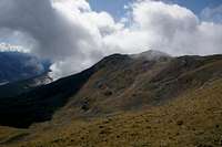
 Äusserer Nockenkopf and Jochbodenkopf
Maps & Books
Maps
- Vinschgau / Val Venosta
Kompass Map WK52
1:50000
ISBN: 978-3-85491-058-9
- Alta Val Venosta / Vinschgauer Oberland
Tabacco Map 43
1:25000
Books
- Vinschgau
Rother Wanderführer
Rother Verlag
ISBN: 978-3-7633-4204-1
- Vinschgau / Ortlergruppe
Kompass Wanderbuch 950
Kompass Verlag
ISBN: 3-87051-404-3