
-
 5257 Hits
-
 85.36% Score
-
 20 Votes
|
|
Mountain/Rock |
|---|---|
|
|
39.71040°N / 21.61980°E |
|
|
Thessaly |
|
|
Trad Climbing |
|
|
Spring, Fall |
|
|
1312 ft / 400 m |
|
|
Overview
Bàntowafels - Eremitenfels
Bàntowafels is one of the best rock climbing destination in the Meteora (Μετέωρα) area, whose meaning is literally "hanging in the air". Meteora is a charming and suggestive climbing venue located in the Thessaly region of Greece. Bàntowafels is a mighty and attractive dome belonging to Meteora Southern Group, located just on the Southern end of the area and overlooking the city of Kalambaka with its unmistakable Southern wall riddled by huge and smaller natural holes in the rock. This superb dome has fairly good rock quality and it became famous and often climbed in reason of a demanding route, currently become an absolutely classic climb not only in Bàntowafels cliff, but in the whole climbing area: Schweizerkas, a German name which literally means "Swiss cheese", referring to the Emmenthal, the well known Swiss cheese with holes.
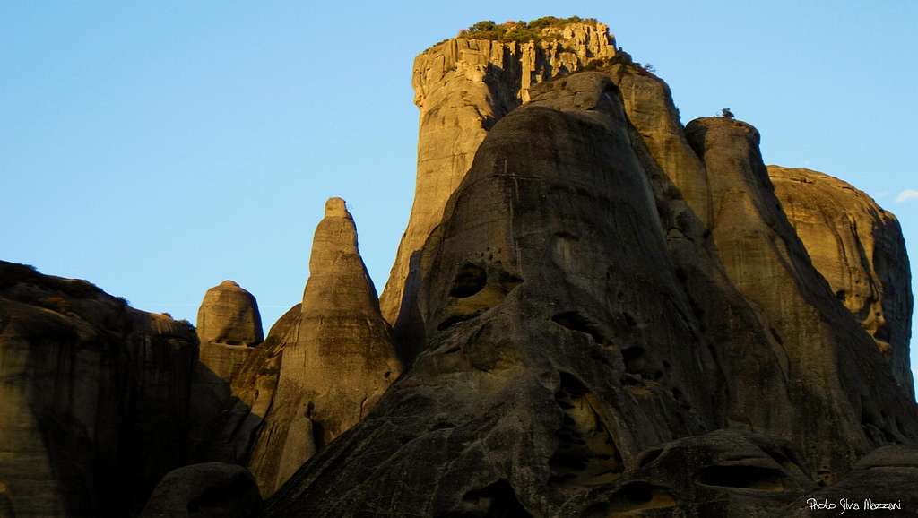
The reason for the strange name immediately becomes intuitive as soon as one look at the shape of the wall along which it runs the Schweizerkas route. Riddled with endless holes!
Bàntowafels is surrounded by close by the majestic peaks of Grosse Heilige, Pixari, Ambaria and by the slender spire called Pyramiden Spitze and in reason of this situation the view from the top is very impressive and fascinating.

|

|
History
All the towers and spires in Meteora area, even the smallest, have a summit book and as a rule usually have two names: the local name in Greek and the German name. This latter originates from the fact that the climb in Meteora had developed thanks to the enormous activities performed by a group of Eastern German pioneers, in primis the physicist Dietrich Hasse and the photographer Heinz Lothar Stutte, who affected by a fascinating picture of Meteora, since the Seventies began to explore the mountain range and climbed all the most important summits, with the exception of the five towers on which lie the monasteries. The same climbers realized two climbing guides of the area.
Getting There
Meteora is situated in the Thessaly region of Greece, Northern half of Greece, approximately 25 km NNW from Trikala, and immediately North of Kalambaka and Kastraki, the two main towns in the area, both located very close to the rocks. The closest main town is Larissa. The distance to Kalambaka is about 360 km from Athens and 237 km. from Thessaloníki.
By plane - Meteora can be approached from Athens Eleftherios Venizelos airport or from Thessaloniki airport. From these airports you can:
- take a domestic flight to Larissa (about 85 km from Kalambaka) - rent a car, useful once you are in Kastraki, but not essential - use public transports (bus or train). Getting to Meteora without a car is easy thanks to the train from Athens that stops in Kalambaka.
, BÃ ntowafels")
|

|
By ferry from Italy – If you wish to travel with your own car, there are different shipping companies and many ferries departures to Igoumenitza harbour from the Italian harbours of Ancona, Bari and Brindisi.
Schweizerkas route report
Bàntowafels - Schweizerkas report (UIAA scale)
Difficulty: Alpine TD, max UIAA VII- all free climbing (or VI- and A1)
Climbing length: 150 m.
Exposure: S
Equipment: pegs
First ascent: Dietrich Hasse - Heinz Lothar Stutte 1976, august 5th
Starting point: Road Kastraki - Kalambaka
A superb climb up a vertical wall, incredibly riddled with huge natural holes in the rock

Approach - The approach involves a short walk directly from the Northern end of Kalambaka through a dirt road rising towards the South wall. Alternatively the approach is done along the road connecting Kastraki with Kalambaka, at about halfway, taking on the left hand (coming from Kastraki) a dead end road that leads after a few hundred meters to a typical tavern. Parking lot. Just behind the tavern there is a path running along the walls. At a junction keep left and after a few minutes you reach the large cave at the base of the wall where it runs Schweizerkas.
Route report - Just outside the cave through which it runs the path you will get to the base of the wall. Climb along a rocky ramp to reach the belay equipped by a fixed anchor at the starting point of the route.


L1 - Climb the vertical wall directly above the belay reaching the next stance. V +, 20 m.
L2 - Unforgettable and magnificent long pitch through a succession of huge holes - the Swiss cheese - which requires an athletic climb with a last harder move in the upper part. Slanting left you reach the next belay below a characteristic "talweg" (drain sculpted by the waters). VI-, 20 m.
L3 - Take the left "talweg" and climb up to a belay at the base of a concave and wide slab. III, IV, IV +, 30 m.
L4 - Up the slab exiting to a small terrace at the base of an overhanging wall, with a tree and a corner-crack on the right. V-, 20 m
L5 - Climb the dihedral crack, starting easy, then more difficult, up to a comfortable small terrace under an overhanging wall. II, V, 20 m
L6 - Crux pitch. There are two way to exit the wall, both difficult. Climb for a few meters the wall directly to a peg, then through a hard traverse to the left, reach a small overhang. Climb it and and bealy at the base of a vegetated slope. V + and A2, 20 m. Alternatively (original exit) traverse left immediately from the belay, then directly to reach the vegetated slope. VII- (or VI-, A1), 20 m. Up the slope, then slanting right along the easy ridge to the magnificent summit. Summit log.
Descent: abseiling the route


Bàntowafels main routes

Besides Schweizerkas, there are some other climbs on Bàntowafels (UIAA scale):
- Nordostweg IV+
- Westkante V, A1 (or VII-)
- Sudwestkante V
- Sudwand-Diagonale V
- Ziegenpfad III
- Direkte Sudwand VI
- Uber den Hexenhals VI-
Red Tape and Ethics
No fees and no permits required. Anyhow, if you are visiting this area, remember that climbing the peaks where the inhabited monasteries are located is prohibited.

In the '70s Dietrich Hasse and his team decided, together with local authorities, not to climb any route on these latter towers. This rule applies even today, together with the suggestion that climbers have not to add fixed protections to the pre-existing ones. Since the year 1988 Meteora was declared a Meteora Unesco World Heritage Site .
Geology and rock climbing
The rock is a gray-brown conglomerate. It is believed that the needles began to form in the Tertiary - about 60 million years ago - starting from the materials deposited at the border of the Thessaly plain when the prehistoric sea waters, which previously covered the plain, withdrew. Slowly the conglomerates needle were then sculpted over the millennia, by water, wind and earthquakes. The texture of Meteora rock results from a mix of pebbles, cobbles and larger stones, packed into a rock surface which appears like concrete but actually is a mixture of conglomerate and sandstone. Sometimes cobbles have come loose from the rock to leave shallow holes in their place.

What emerges is a peculiar climbing style, mainly slabby and balancy on cobbles, consisting in exploiting small or large pebbles protruding, or otherwise the holes remained where the same pebbles were formerly located. As soon as you get used to it, the climb will provide fun and generally little tiring.
Nature and climate

The vegetation is considered as supra-Mediterranean, with climax cover of Quercus and Ostrya species and Fagus sylvatica beech forest above 700 m. The area includes forested hills and river valley with forests of Platanus orientalis and species such as the endemic Centaurea lactifolia Centaurea kalambakensi. Meteora during the summer is influenced by the climate of the tropics extending its influence into the Mediterranean area and therefore a great heat can be expected, while during the winter the area is influenced by the Central Europe climate, that often produces changes from fair weather conditions to bad weather conditions. Best seasons are the middle ones: Spring till middle May and early Fall.
When to climb

In theory it's possible to climb all year round (snowfalls are rare), but summer and winter are not advisable because temperatures may be unpleasant, unless you are very lucky. The best months are late March, April, May, September and October.
Accomodation
There is a wide choice of hotels, B&Bs, rooms for rent and three organized campsites. The nearest campsite to the crags is Camping Vrachos in Kastraki, the village built in the shadow of the Meteora towers. There is also a smaller campsite near the tower of Doupiani.
The nearby town of Kalabaka also features many accomodation choices. There are plenty of eating out options, particularly tasty traditional Greek food and pizzerias, both in Kastraki and Kalambaka.
Guidebooks and maps
There are two useful guidebooks to consult:


“Meteora – Climbing and hiking” by Dietrich Hasse and Heinz Lothar Stutte - I edition 1986, in English and German. It contains around 230 routes. Also, it provides general information about mountaineering, hiking in Meteora, maps, directions.
The second guidebook is:
“Meteora Climbing Part II” by the same Heinz Lothar Stutte and Dietrich Hasse – II edition 2000 – German, Greek and English - Note: the II edition is not a complete guidebook, but an update to the I edition
The Meteora guidebooks can be purchased in Kastraki, Taverna Paradisos or Camping Vrachos. There is also a useful map by the same authors that can be purchased in local shops in Kastraki.