
-
 17894 Hits
-
 75.81% Score
-
 6 Votes
|
|
Trailhead |
|---|---|
|
|
Los Angeles |
|
|
Spring, Summer, Fall, Winter |
|
|
1100 ft / 335 m |
Overview: Hiking and Canyoneering
This trailhead (elevation 1,100 ft.) provides access to Bailey Canyon, a relatively short, but deep, narrow and rugged canyon that scours a path about a mile into the San Gabriel foothills above Sierra Madre, California. In the 1880’s, the canyon was a mecca for the commercial trapping of foxes and coyotes. Today, the canyon’s uses are strictly recreational. However, the coyotes are still there and are apt to be seen in the early evenings near the bottom of the canyon.The trailhead affords direct access to Jones Peak, Hastings Peak, Mt. Yale, and Mt. Wilson in the San Gabriel Mountains front range.
 Jones Peak (3,375') seen from Bailey Canyon Park Trailhead
 Hastings Peak (4,000') seen from Bailey Canyon Trail
 Mt. Harvard (5,441') seen from summit of Jones Peak
There is one trail out of the trailhead and its path begins at the west end of the trailhead parking area.
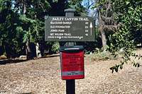 Bailey Canyon Trailhead Sign
In 0.3 miles, there is a short, looped nature trail (the Live Oak Nature Trail) that splits right off the main trail. At 0.4 miles, the trail hits a streambed and the Canyon View Nature Trail splits off to the left and follows the streambed for 0.2 miles to the Falls. The (main) Bailey Canyon Trail continues up the east slope of the canyon 2.8 more miles to the saddle north of Jones Peak. From the saddle, a firebreak along a ridge going northwest connects to the Mt. Wilson Toll Road 5 miles from the trailhead, and one can continue up to Mt. Wilson along the toll road.
 In foreground is the ridge that curves northwest from Jones saddle and connects with the Mt. Wilson Toll Rd.
Alternatively, a trail starting 0.2 miles north of the saddle drops 700 feet into Little Santa Anita Canyon to connect with the Mt. Wilson Trail. Continue on the Mt. Wilson Trail to Mt. Wilson.
 Looking down from Jones Saddle into Little Santa Anita Canyon and the Mt. Wilson Trail
Bailey Canyon is also used for canyoneering. The descent begins behind some stone cabin ruins just off the main trail 2.2 miles from the trailhead and high above the cliffs and waterfalls of the lower canyon. See “Adventure Hikes and Canyoneering in the San Gabriels” by Christoperher E. Brennen
Driving Directions
The Bailey Canyon Park Trailhead is also known as Grove Park. It is situated within the city limits of Sierra Madre. From the 210 Freeway, exit at Santa Anita Ave. and go north. Turn left (west) on Grand View. Continue several blocks to Grove. Turn right (north) onto Grove and drive directly into the Bailey Canyon Park/Grove Park parking lot. There is a gate at the entrance to the park open “from dawn to dusk.” If you get there before the gate is open, there is parking along adjacent residential streets.Red Tape
No permits are needed for any hikes from this trailhead. Neither is an Adventure Pass required to park at the trailhead because it is not located within the Angeles National Forest.When to Visit
This trailhead is accessible year round. However, keep in mind that the main trail up the canyon is exposed to the sun, so hot summer days would not be the best time to hike here. A further caveat is to stay away from this deep canyon during or shortly after a rain. In 1994, a debris flow resulted in hiker fatalities.[img:238667:aligncenter:small:Flash Flood Warning Sign at entry to Bailey Canyon]