
-
 12682 Hits
-
 72.08% Score
-
 2 Votes
|
|
Trailhead |
|---|---|
|
|
Los Angeles |
|
|
Spring, Summer, Fall, Winter |
|
|
3650 ft / 1113 m |
Overview: Hiking and Biking
This trailhead in the front range of the San Gabriel Mountains is centrally located being a stone’s throw from the intersection of the Angeles Crest and the Angeles Forest highways. It provides the most direct access to Josephine Peak and also access to Strawberry Peak, Mt. Lawlor, and trails in the vicinity of Strawberry and Lawlor.The Josephine Fire Road (designated 2N64) climbs north along the ridge separating Colby Canyon from Clear Creek. It is, for the most part, an unshaded road. However, in the spring, there is a bush growing along the bottom part of the fire road that unleashes a beautiful yellow bloom with a nice fragrance to boot.
The fire road ascends 2.4 miles to the crest of Josephine Peak’s east ridge (4,890’). From this junction, if you go right (east), you will reach Josephine Saddle in 0.5 miles. The Colby Canyon Trail intersects here coming up from the Colby Canyon trailhead. From Josephine Saddle, you can take one of two routes to Strawberry Peak, at 6,164 feet elevation, the highest peak in the San Gabriel front range.
 Strawberry Peak from near Clear Creek Junction
 Mt. Lawlor from near Clear Creek Junction
If you go left (west) at the junction, the road ascends the ridge on its north side to Josephine Peak (5,558’) in 1.5 miles.
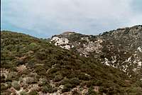 Josephine Peak (center) from Josephine Fire Road trailhead
A round-trip to Josephine Peak from this trailhead will be about 8 miles with 2,100 feet of gain.
Josephine Fire Road is also an excellent mountain bike route. You can ride all the way to the bottom of Josephine Peak’s summit area and leave your bike to hike the short distance to the summit.
Driving Directions
From the 210 Freeway, exit at Angeles Crest Hwy (SR 2) and go north. At 9.5 miles, you will come to the Clear Creek Information Station and junction with Angeles Forest Highway. The trailhead, marked by a white fire road gate, is located about 50 yards north of the intersection on the east side of Angeles Forest Highway.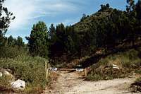 Josephine Fire Road Trailhead
Parking is available at two spots. One is on the west side of Angeles Forest Highway facing the fire station and just across the street from the fire road gate. The other parking location is a large unpaved area right at the Angeles Crest and Angeles Forest highway intersection. At either place, you must display your Adventure Pass.
Red Tape
You will need an Adventure Pass to park your vehicle anywhere within the Angeles National Forest, including this trailhead. These passes are currently sold at the Clear Creek Information Station ($5 per day or $30 for a yearly pass). This information station is located on the south side of the Angeles Crest Highway right where it intersects with the Angeles Forest Highway. Otherwise, Adventure Passes are also sold at most sporting good stores in Southern California.No permits are required for hiking any of the trails accessible from this trailhead.
When to Visit
The trailhead is, for the most part, accessible year-round. However, during winter months when it snows, you may need chains to get to the trailhead.Other Information
There is no water source along the fire road. Further, the section of fire road up to Josephine Peak’s east ridge has no shade to speak of so be forewarned during hot summer days.USGS Topos Condor Peak 7.5