
|
|
Mountain/Rock |
|---|---|
|
|
42.09093°N / 74.48802°W |
|
|
Ulster |
|
|
Hiking |
|
|
Spring, Summer, Fall, Winter |
|
|
3610 ft / 1100 m |
|
|
Overview
Balsam Mountain, in the Catskill Range of New York, is one of 35 mountains in that region that is over 3500 feet in elevation. Many hikers pursue a goal to reach the summit of all of them, so they have to pay Balsam a visit. The Catskill 3500 club, which oversees the list, also makes aspiring hikers climb four again in the winter, and Balsam is one of the four. There are two other peaks out of the 35 that also have Balsam in their name, and they are Balsam Lake Mountain, and Balsam Cap Mountain.The summit of Balsam Mountain is on the Pine Hill-West Branch trail, at least according to the map. There is nothing to mark the summit, which is a common occurrence among Catskill peaks. I don't understand why the summit is not marked, but that's just the way it is. One can stomp around off trail until you feel you have reached the highest ground, or hike both sides of the trail until you are going downhill again, in order to know you've been on the summit.
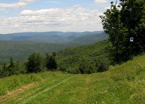
There are several approaches you can take to reach Balsam. Ultimately you have to get onto the Pine Hill-West Branch trail, which can sometimes be rough to hike on because the forest is taking back some of the trail. (Don't say you weren't warned). Balsam is in the Big Indian Wilderness, which is one of the more remote, and least visited areas of the Catskills. It's not like the Devil's Path and Indian Head Wilderness where there are great views of the mountains. In the Big Indian Wilderness there's very few viewpoints, but it just so happens that north of Balsam's summit is a decent one, easily located off the Pine Hill-West Branch trail.
 Balsam viewpoint
One could start at the southern terminus of the Pine Hill-West Branch trail and hike all the way to Balsam, passing Big Indian and Eagle Mountain along the way, but that would be a long hike of almost 10 miles one way. So often one hikes to Balsam from either McKenley Hollow from the east, or Rider Hollow from the west. However one can approach from the north and get to see Belleayre Mountain, which is not a major peak in the Catskills, and it's outstanding views. Still another possibility would be to take the Seager-Big Indian trail from the west, to the Pine Hill-West Branch trail, passing Eagle Mountain and Haynes Mountain along the way.
The quickest way to get to Balsam would be from either end of the Oliverea-Mapledale trail that starts in the east from McKenley Hollow, and from the west from Rider Hollow. Both sides of the trail meet about halfway on the Pine Hill-West Branch trail (the total trail length of the Oliverea-Mapledale trail is 3.6 miles), and from there it's almost a mile until you reach Balsam. Remember shortly after the summit is a good viewpoint if you're coming from the south on the Pine Hill-West Branch trail. The Oliverea-Mapledale trail is steep, particularly on the McKenley Hollow side, plus there are some tricky stream crossings to be dealt with as well. It is said to be dangerous in icy conditions. From the west and Rider Hollow it's also possible to take the Mine Hollow trail which branches off the Oliverea-Mapledale trail. The Mine Hollow trail brings you north of Balsam, but it is not as steep as the Oliverea-Mapledale trail.
One can also hike in from the north to reach Balsam. You could start at the northern terminus of the Pine Hill-West Branch trail or take the Cathedral Glenn trail, which is right there as well, and meets up with the Pine Hill-West Branch trail via the Belleayre Ridge trail. Belleayre Mountain's summit is in a clearing, but the ski area which is not that far away has some great views. It's also possible to hike the Lost Clove trail, which is steep, but wide and easy to follow, until it reaches the Pine Hill-West Branch trail shortly before Belleayre's summit. Whatever way you take from the north it is under 3 miles from Belleayre's summit to Balsam. Just before Balsam's summit is the viewpoint when you hike in from the north.
 Belleayre
So if you're looking for some solitude, some remote wilderness, a nice hike through the forest, and you want to go up a major Catskill peak, then you might like Balsam. It has a decent viewpoint, which is hard to find in the Big Indian Wilderness, and there's opportunities for camping no matter what approach you take. If you have the time you can combine it with a trip to Eagle Mountain or Belleayre Mountain, or both.
Getting There
If you're taking the northern terminus of the Pine Hill-West Branch trail or the Cathedral Glenn trail you head for Pine Hill, NY on NY 28 around 30 miles or so from Kingston, NY (Exit 19 off I-87). The Lost Clove trail and the Oliverea-Mapledale trail from McKenley Hollow are both off CR 47 (Slide Mountain Road or West Branch Road) which is off NY 28 near the town of Big Indian. The Seager-Big Indian trail is at the end of CR 49 (Dry Brook Valley Road) which is reached off NY 28 from the town of Arkville. The Oliverea-Mapledale trail from Rider Hollow is off of CR 49 (Dry Brook Valley Road) on Rider Hollow Road. (You need to check for the exact directions on that one.)Red Tape
There's really no red tape to deal with. Parking at any of the trailheads is free. Make sure you follow the simple regulations for camping. However I don't know about wandering over to Belleayre's ski center during ski season. You might want to check that out for yourself.Camping
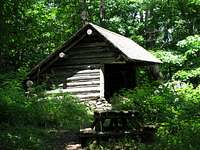
There are lean-tos from whatever way you approach. From the north there's the Hirschland lean-to on the Belleayre Ridge trail, and the Belleayre Mountain lean-to on the Pine Hill-West Branch trail near the Lost Clove trail. From Rider Hollow there's the Rider Hollow lean-to, and from McKenley Hollow there's a lean-to off the Oliverea-Mapledale trail. On the Seager-Big Indian trail there is the Shandaken Creek lean-to. In general you can't camp over 3500 feet in NY from March 21st until December 21st. You want to make sure you camp at least 150 feet away from a trail.
External Links
Are you looking to join a mountain club that goes on some hikes to the Catskills? Two good ones are the Appalachian Mountain Club and the Adirondack Mountain Club.Some websites that I pay a visit to for Catskill info are the Catskill-3500 Club and Catskill Hiker.
I've got this guidebook and I recommend you get it too, if you want good info on the Catskills.
For weather info I stop by NOAA or Weather Underground.
For peakbagging information check out Peakbagger.