
-
 25421 Hits
-
 90.32% Score
-
 33 Votes
|
|
Mountain/Rock |
|---|---|
|
|
35.82901°N / 106.64347°W |
|
|
Hiking, Trad Climbing, Scrambling |
|
|
Spring, Summer, Fall |
|
|
6785 ft / 2068 m |
|
|
Overview
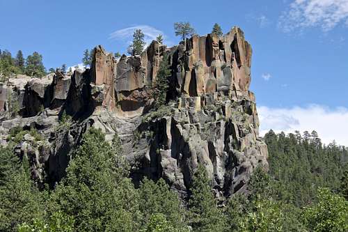
Battleship Rock as seen from State Highway 4
Battleship Rock is a spectacular basalt rock cliff at the confluence of the Jemez River and the East Fork of the Jemez River. The formation is located in north-central New Mexico in the Jemez Mountains. Battleship Rock rises nearly 200 feet, creating an impressive rock formation seen from the Hwy 4. It resembles Navy warship, therefore its name.
The Battleship Rock Picnic Area, a day use park, also features a trail that lead to McCauley Warm Springs. McCauley Springs are surrounded by a high mountain meadow, hovers around 99 degrees, making an excellent spot for a soak after a hike (or climb of Battleship). It takes two miles to reach McCauley Springs. If you are tired, don't worry, there are Spence Hot Springs, just a couple of miles drive on Hwy 4, and those are less than 1/4 mile hike. The water here is much warmer.
Route

Battleship Direct 5.8

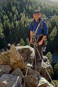
Getting ready for the climb
Battleship Rock is a sheer cliff that rises suddenly above the river like a prow of a ship. The day use picnic area below is very popular destination, so be prepared for tons of spectators.
There are 3 described routes on this formation with a potential of new routes. Battleship Direct 5.8 (the only route I did, once in 2009, and once in 2010) is mentioned in Jemez Rock guide book by Marc Beverly as the only route worth doing there.
Park at the free parking by Hwy 4 and take the pathway down through the Day Use Picnic Area towards the stream. Cross the bridge and hike past gazebo to the foot of Battleship Rock. There is a small distinct trail around to the left side of the cliff. You have to 4th class a little bit to a ledge that traverses back around to the arete. The climb has 2 pitches.
Pitch 1: Start at the base of the nose (=arete) and climb up the ridge on the right side using small camps and stoppers. This pitch basically follows the arete forming the prow of the ship for almost full rope length. Come to a headwall and clip two old rusted bolts and move left, avoiding the headwall above the bolts, into a gully that takes you behind the headwall and to a ledge for a belay. It is easy 5.6 climbing.
Pitch 2: This pitch continues slightly left from the belay ledge and little on the left side of the prow. It is shorter, and more fun. Climb up to ledges, little cracks, come to a large chockstone, which makes a tunnel. If you're small you can squeeze through (we did). Otherwise go up and over it for a fun finish.
Protection: Standard trad rack up to camalot #3, long draws, 60 meter rope. Personal climbing gear: shoes, harness, helmet. Bring your approach shoes for the descent. The hike down is about 15-20 minutes.
Descent: Walk off is up and left - there is a path down to the parking lot.
Red Tape

Approach to Battleship
Summit of Battleship
Battleship Picnic Area is now Day Use Area only (day use from sunrise to sunset). It has one round wooded shelter with tables and four fire grills, 33 picnic units with tables and grills, chemical toilets, and drinking water.
This is also the trailhead for the McCauley Warm Springs (see below).
Fee: 5.00$ per vehicle if you enter the Battleship Day Use Picnic area (free parking lot by the highway 4 - this is the recommended parking lot for hikers/climbers).
Pets should be on leash.
Expect a lot of spectators, and take care of not throwing rocks on them from your climb.
When to Climb
Rock Climbing: Spring, Summer, and Fall are the best seasons. The area does get a lot of snow in the winter, but warm winter days may be nice too.
Hiking: any season. The warm springs are truly only warm, temperature in 90s, so if you are planning to soak in the middle of the winter, consider Spence Hot Springs, just a couple of miles up the road.
Getting There
Soda Dam in the winter

Soda Dam and Duchess

Exploring Soda Dam
The Jemez Mountain Trail is a beautiful drive full of the history of the Jemez People and surrounded by some of the stunning scenery in the southwest. The Jemez (pronounce Hemez) Mountain Trail is an intersection of roads that includes Highway 550 and Highway 4. It starts at the Coronado Monument in Bernallilo (outskirts of Albuquerque) and encompasses the Jemez State Monument, Valles Caldera Preserve and finishes at Bandelier National Monument. It is filled with many opportunities for hiking, fishing, camping, cross-country skiing, mountain biking, climbing, or visiting natural hot springs.
The worthwhile stop on your way to Battleship Rock is Soda Dam - located right along the Highway 4. Is an interesting formation. The water from underground hot springs has formed a unique and spectacular natural dam that blocks the Jemez River. It is one of the most photographed spots on the Jemez Mountain Trail. Soda Dam appears like an outer-worldly mass of gnarled and twisted rock. It is 40 feet high and still growing. The area has a sulfurous odor.
At mile marker 24 on Hwy 4 is the clearly obvious formation known as Battleship Rock. Its presence looms over the bifurcation of the two rivers that form the main Jemez River. It is hard to miss. It is about 5 miles from Jemez Springs.
Just a couple of miles past Battleship is a large parking lot on your right side. This is the place for visiting Spence Hot Springs. The Springs are not seen from the Highway 4, but the hike is very short (~ 1/4miles). You follow a well worn path down to the river, cross on the bridge and walk up the hill towards the springs. There are several hot pools.
Hike to McCauley Hot Springs

McCauley Warm Springs

Lurking Duchess into the water
One of my favorite warm springs in New Mexico. The pools are large and someone brought guppies in. My son used to love to swim there and catch little fish.
Parking for Trail 137 is located north of Battleship Rock Picnic Area, off NM State Highway 4. To access Trail 137 walk through the picnic area, trail is located to the eastside of the pavilion. (You can park at the picnic area, but then you have to pay a day use fee of 5$, parking at the road site is free).
This route follows the left bank of the East Fork of the Jemez River. Stay on the main trail and after about 0.5 miles, Trail 137 leaves the river to switchback up the mountainside and is easy to follow. After about 1 mile the Battleship Rock Trail winds over a relatively level shelf before climbing again to the final shelf where the spring is located.
The main pool (see photos) is fed by a spring issuing from the mountainside; downslope from this pool are several smaller but more private pools. As at most backcountry hot springs, local custom is "swimsuits optional".
Don't be misled by the term "hot spring". This is more of a "warm spring", and for this reason, it's not a good choice for a winter soak. If you wish winter soak, visit Spence Hot Spring a couple of miles up the Highway 4 from Battleship.
Camping
Battleship picnic ground is now a managed day use area and no overnight camping is allowed.
Jemez Mountains offer several official campgrounds: San Antonio, Jemez Falls, and Redondo Campground are all within 10 mile driving distance.
You can get accommodations in the town of Jemez Springs.
Jemez Springs Lodging
External Links
Battleship Rock on Mountain Project