
-
 26333 Hits
-
 79.96% Score
-
 12 Votes
|
|
Area/Range |
|---|---|
|
|
35.82756°N / 106.51546°W |
|
|
Hiking, Sport Climbing, Toprope, Bouldering, Mixed, Scrambling, Skiing |
|
|
Spring, Summer, Fall, Winter |
|
|
11561 ft / 3524 m |
|
|
Overview

The Jemez Mountains lie along the Great Rift Valley of the Rio Grande of north central New Mexico. Their recent volcanic origin is evidenced by large basaltic flows, the tweleve mile-wide Valle Cauldera as well as numerious hotsprings. The ruins of past cultures are preserved at Bandelier National Monument,who's ancesters continue to inhabit no less than eight Pueblos surrounding the Jemez. The many streams that flow through the Jemez Mountains offer trout fishing, beautiful waterfalls and other geological wonders. Bandelier National Monument offers hiking/backpacking through multicolored canyons to explore ancient ruins. Limitless rock climbing on basalt flows near the towns of White Rock and Cochiti lake. The Jemez mountain region lands are managed by Valles Caldera National Preserve, Santa Fe National Forest, Bandelier National Monument and of course the Pueblo tribal governments.
Getting There
Western Approach & Valle Grande
Travel north on I-25, Exit to US 550 at Bernalillo (Exit 242)travel north to the small villege of San Ysidero. Take State Highway 4 to reach the heart of the mountains and Valles Caldera National Preserve or continue north on US 550 along the Sierra Naciminento Range and access to the San Pedro Parks Wilderness Area north of the town of Cuba.
Eastern Approaches
Take Interstate Highway 25 to Santa Fe, continue thru Santa Fe on US 84/285 and follow signs towards Los Alamos (Highway 502), after crossing the Rio Grande a major highway junction will go to Los Alamos (Highway 502) or State Highway 4 to Bandelier. Highway 4 is one of the most scenic roads in the state as it crosses the Valle Grande and continues on to Highway 550 on the western side of the mountains.
MORE TO COME
Red Tape
To enter the Jemez Mountains simply drive the State roads into them at any time, however there are a number of land ownerships which have their own set of rules for entering. Along the west and southern parts of the region as well as the northeastern approaches are eight Indian Pueblos. This land should be looked on as being private,entering only areas and following the special rules posted on signs within the PueblosCochiti Rocks
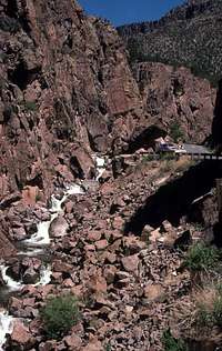
Eagle Canyon and Cochiti Mesa rock climbing areas are reached from I-25 by taking Exit 259, NM 22 (if coming from Albuquerque) or Exit 264 NM 16 (if coming from Santa Fe). NM 16 will intersect NM 22(go rt). Continue on NM 22 past the Cochiti Lake Dam and thru the town of Cochiti Lake to Forest Road 289, on your rt past the golf course. Follow FS Road 289 to a parking area at 4 miles signed "Dome Wilderness Trail"(USFS). This is the back entrance to Bandelier National Monument's Wilderness. Follow a faint trail the opposite direction for the Eagle Canyon Climbing area.
Continuing on FS Road 289 to mile 7.1 and reach Cochiti Mesa climbing area. The FS road is a rough road that requires careful driving in high clearance vehicles. Beware!
White Rock Climbing Area
The climbing area lies at the White Rock Overlook which is located in the small community of White Rock outside of Los Alamos. Look for signs for the city park which you must pass thru to reach the overlook. It can be difficult to locate because the turn is within a neighborhood off of NM 4.
UNDER CONSTRUCTION
External Links
Walatowa-Pueblo of JemezValles Caldera National Preserve
Santa Fe National Forest
Bandelier National Monument
Camping
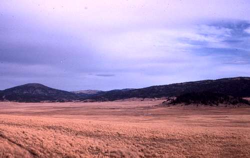 The Valle Grande, now a lush meadow, lies within the cauldera of an volcano. The cauldera was once filled by a lake much like todays Crater Lake of Oregon. State Highway 4 now traverses the canyon formed when the lake drained.
SANTA FE NATIONAL FOREST
Much of the Jemez Mountains are contained within the Jemez Ranger District of the Santa Fe National Forest. Four campgrounds are accessiable from NM 4.
Redondo Campground
59 Units available($10/night)Located 4 miles east of La Cueva on NM 4
Jemez Falls Campground
52 Units ($10/night) Located 6 miles east of La Cueva on NM 4 Beautiful Jemez Falls is a short hike and a bit further down the trail is a large hotspring.
San Antonio Campground
47 units ($10/night) From Jemez Ranger Station travel 7.5 miles north to Hiway 126, turn left, CG 2 miles.
Vista Linda Campground
13 Units sit along the Jemez River. 5.6 miles south of Jemez Ranger Station
BANDELIER NATIONAL MONUMENT
More than 70 percent of the park is contained within the Bandelier Wilderness (with an additional 5,200 acres contained in the adjacent Dome Wilderness, Santa Fe national Forest). Backcountry camping is allowed with a free permit available at the visitor center up to 20 minutes before closing time. The closest backcountry area is 2 miles from the visitor center.There are more than 70 miles of hiking trail.
Near the park entrance(on the mesa top, not in the canyon where the visitor center is located) is a family campground that gets light use so a camp site is usually availble.