
-
 22421 Hits
-
 75.81% Score
-
 6 Votes
|
|
List |
|---|---|
|
|
Summits Over 9,000'
There are quite a few unnamed peaks in the Bitterroot Mountains, some with summits over 9,000'. This list includes some of those "unnamed" peaks along with the names some (locals) have "unofficially" applied to them.
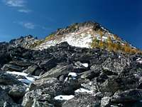 Bare Peak
Each of the unnamed peaks is listed as: Unofficial Name (point nnnn).
The Latitude and Longitude are also listed for each summit to help anyone unfamiliar with the area discover its location.
More than likely this list is not perfect, so if you find errors or omissions, please let me know so I can make corrections.
 The Como Peaks. Photo by Corey Stelling. The Como Peaks. Photo by Corey Stelling. |
| Summit Name | Elevation | Latitude | Longitude |
|---|---|---|---|
| Trapper Peak | 10,157' | 45.88989 N | 114.29685 W |
| El Capitan | 9,983' | 46.00746 N | 114.39604 W |
| The Shard (point 9883) | 9,883' | 45.95842 N | 114.33598 W |
| Boulder Peak | 9,804' | 45.84721 N | 114.34191 W |
| North Trapper Peak | 9,801' | 45.90064 N | 114.28955 W |
| Trapper Peak - West (point 9772) | 9,772' | 45.89138 N | 114.31891 W |
| Como Peak - West | 9,624' | 46.00217 N | 114.35064 W |
| Little Tin Cup Peak (point 9617) | 9,617' | 45.96837 N | 114.31320 W |
| Saint Joseph Peak | 9,587' | 46.60158 N | 114.25399 W |
| Sugarloaf Peak | 9,586' | 45.94176 N | 114.30702 W |
| Como Peak - Middle | 9,530' | 46.00175 N | 114.34285 W |
| South Chaffin Peak (point 9486) | 9,486' | 45.93504 N | 114.35117 W |
| Como Peak - East | 9,485' | 45.00485 N | 114.33147 W |
| Bare Peak - East (point 9459) | 9,459' | 45.84516 N | 114.38828 W |
| Boulder Peak - East (point 9442) | 9,442' | 45.84575 N | 114.32253 W |
| Bare Peak - North (point 9439) | 9,439' | 45.85160 N | 114.40879 W |
| Mink Peak (point 9363) | 9,363' | 45.89770 N | 114.34092 W |
| Mount Jerusalem | 9,355' | 45.82466 N | 114.46007 W |
| Saint Mary Peak | 9,351' | 46.51159 N | 114.24346 W |
| West Chaffin Peak (point 9340) | 9,340' | 45.94124 N | 114.35522 W |
| Boulder Peak - West (point 9334) | 9,334' | 45.85547 N | 114.36208 W |
| South Heavenly Twin | 9,282' | 46.51424 N | 114.29822 W |
| Little Tin Cup Point (point 9265) | 9,265' | 45.97181 N | 114.29668 W |
| North Heavenly Twin | 9,243' | 46.51907 N | 114.30063 W |
| Trapper Lake Peak (point 9260) | 9,260' | 45.91014 N | 114.38505 W |
| Chaffin Point (point 9238) | 9,238' | 45.94895 N | 114.34769 W |
| Lonesome Bachelor | 9,185' | 45.99995 N | 114.37304 W |
| Boulder Creek Peak - East (point 9184) | 9,184' | 45.89174 N | 114.35188 W |
| Mount Jerusalem - North (point 9169) | 9,169' | 45.83887 N | 114.46876 W |
| Whites Mountain | 9,162' | 46.07316 N | 114.41240 W |
| Sweeney Peak | 9,161' | 46.64801 N | 114.22049 W |
| Canyon Peak | 9,155' | 46.24491 N | 114.35293 W |
| Lolo Peak - South Summit | 9,139' | 46.67466 N | 114.24359 W |
| Boulder Peak - North (point 9125) | 9,125' | 45.85386 N | 114.33917 W |
| Ward Mountain | 9,119' | 46.16911 N | 114.28477 W |
| Lolo Peak - North Summit | 9,096' | 46.68201 N | 114.23737 W |
| Whites Mountain - East (point 9095) | 9,095' | 46.06909 N | 114.36942 W |
| Koch Mountain | 9,072' | 46.07739 N | 114.36591 W |
| North Canyon Peak (point 9042) | 9,042' | 46.25308 N | 114.35101 W |
| Little Saint Joseph Peak (point 9033) | 9,033' | 46.60191 N | 114.21317 W |
| Boulder Creek Peak - West (point 9019) | 9,019' | 45.88959 N | 114.36735 W |
| North Lost Horse Creek - North Ridge (point 9018) | 9,018' | 46.16778 N | 114.35050 W |
| Trapper Creek Peak (point 9012) | 9,012' | 45.90140 N | 114.39414 W |
| Stormy Joe (point 9003) | 9,003' | 46.60116 N | 114.27913 W |