-
 20232 Hits
-
 84.82% Score
-
 19 Votes
|
|
Mountain/Rock |
|---|---|
|
|
40.20464°N / 123.00928°W |
|
|
Trinity |
|
|
Hiking, Scrambling |
|
|
Spring, Summer, Fall |
|
|
7755 ft / 2364 m |
|
|
Overview
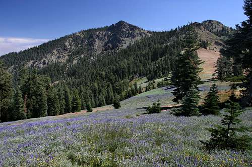
Standing lonely sentinel at the southern periphery of California’s Klamath Mountains, Black Rock Mountain is one of the twin guardians of the North Yolla Bolly Mountains. Along with its slightly taller sibling, North Yolla Bolly, these geminated peaks are the southernmost outpost of one of the Golden State’s greatest, yet least known mountain ranges. The reasons for the near-forsakenness of the Yolla Bollys are numerous. For one, they are simply just too remote. It is easier to get to some of the far more spectacular corners of the Klamaths than it is to get to the Yolla Bollys. Making matter worse, how many people have actually heard of the Yolla Bolly Mountains? Well known or not, this area is classic Klamath terrain. All of the essential ingredients are here: lakes, rugged peaks, lush meadows, unusual flora and a deep sense of isolation, made all the better with the knowledge that one is in one of those classic wilderness areas where the land is so forgotten that even the name seems foreign on the tongue. As previously stated, Black Rock Mountain offers all of the core distinctives of the Klamath Mountains, albeit in portions that are sometimes somewhat smaller than elsewhere in the range or in hues that are a bit more muted than other fellow ranges in the Klamaths. In spite of this, Black Rock Mountain and the rest of the North Yolla Bollys are attractive and worthy of greater exploration.
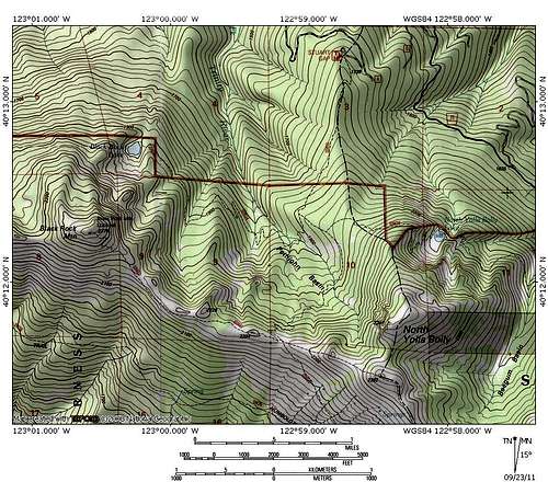
Black Rock Mountain marks the western end of a long ridge that connects the peak to North Yolla Bolly, the highest point in the North Yolla Bolly Mountains. Only 108 feet shorter than North Yolla Bolly, Black Rock Mountain still offers an excellent summit that boasts somewhat better views than its eastern twin. This is so because, being situated further to the west, Black Rock takes in much of the Cascades and Sierra Nevada like North Yolla Bolly, as well as the entire southern half of the Klamath Mountains. All of this is in addition to most of the North Coast Range. The western views reach almost all the way to the Pacific Ocean. Evidence for Black Rock Mountain’s superior views is demonstrated by the presence of a Forest Service lookout tower on the summit. The view from the summit is also distinctive because it affords the opportunity to see the transition from the Klamath Mountains to the North Coast Range.
Like many other peaks in the Klamath Mountains, particularly in the southern half of the range, Black Rock Mountain has a stark contrast in appearance between its northern and southern faces. The south face is covered in a thick blanket of brush, with occasional protrusions of rock and tree. Conversely, the north face of the mountain is a rugged, rocky exposure with occasional trees. The rocky cliffs are punctuated by the presence of small but pretty Black Rock Lake. The southern/northern appearance dichotomy holds true for most of the great peaks in the (relatively) nearby ranges of the Trinity Alps and the Trinity Divide. In this way Black Rock Mountain is more representative of the Klamaths than North Yolla Bolly, which has a grassy southern face.
Despite being a distant frontier of the Klamath Mountains, Black Rock Mountain and the North Yolla Bolly Mountains are included in the Yolla Bolly-Middle Eel Wilderness, a wilderness area that is generally iconic of the North Coast Range. While the North Yolla Bollys constitute the northern verge of the wilderness, the South Yolla Bollys anchor the southern end and include Mount Linn (also known as South Yolla Bolly), which is the highest point in the North Coast Range. As the name indicates, the wilderness is the headwaters of the Middle Fork of the Eel River, one of the Coast Ranges’ greatest waterways. However, the North Yolla Bollys are also the source of Cottonwood Creek, one of the Sacramento Rivers largest tributaries, as well as the South Fork of the Trinity River. The wilderness is one of the least visited in California, generally getting most of its use during hunting season. In spite of this, those who do undertake the journey to reach the Yolla Bollys will not be disappointed with the beautiful scenery in an isolated an unknown mountain range.
Maps
North Yolla Bolly MountainsYolla Bolly - Middle Eel Wilderness
Route
Detailed route information can be found here.Getting There
Getting to the North Yolla Bollys is a long drive, no matter which direction one comes from. The mountains are located south of Highway 36, which is one of several state highways that transect the North Coast Range. Consequently, the North Yolla Bollys can be accessed from either Highway 101 in the west or Interstate 5 in the east. Directions from both sides are given (the same cannot be said for the South Yolla Bollys, which are only accessible from the east).From Highway 101:
From the intersection of Highways 101 and 36, drive east on Highway 36 for 81.5 miles. Just before the bridge crossing over Hayfork Creek, turn right onto Forest Road 30 / Wildwood-Mad River Road.
From Interstate 5, southbound from Redding:
From Redding, continue south on Interstate 5 to Cottonwood. Take exit 662 for Bowman Road. Drive west on Bowman Road for 14 miles to the intersection with Highway 36. Turn right onto Highway 36 and continue west for 37.5 miles. Turn left onto Forest Road 30 / Wildwood-Mad River Road just after crossing the bridge on Hayfork Creek.
From Interstate 5, northbound from Red Bluff:
As one enters Red Bluff on Interstate 5, take exit 650 for Adobe Road. Turn left onto Adobe Road and then right onto Main Street. Continue for 0.5 miles and then turn left onto Highway 36 / Beegum Road. Continue on Highway 36 for 55 miles. Turn left onto Forest Road 30 / Wildwood-Mad River Road just after crossing the bridge on Hayfork Creek.
From the intersection of Highway 36 and Wildwood-Mad River Road:
Once on the Wildwood-Mad River Road, drive 9 miles to Pine Root Saddle. Turn left onto paved Forest Road 35. Follow this road for another 10 winding miles to Stuart Gap, which is a nexus of five roads. Veer slightly right (roughly 2:00) onto a dirt road signed for the Stuart Gap trailhead. Stay on this road for almost 2 miles to the trailhead.
Red Tape
Black Rock Mountain is located in the Yolla Bolly - Middle Eel Wilderness. Normal wilderness rules and ethics apply.
Shasta-Trinity National Forest
3644 Avtech Parkway
Redding, CA 96002
(530) 226-2500
Yolla Bolla Ranger Station
2555 State Highway 36
Platina, CA 96076
(530) 352-4211


